Property Record
513 Route 539, Whiting, NJ 08759
NEARBY LISTINGS FOR SALE OR LEASE
-
-
View all Whiting listings for sale on LoopNet.com
Property Detail
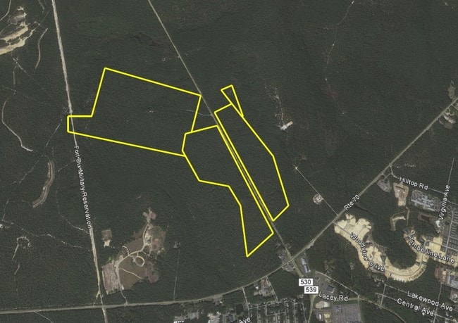
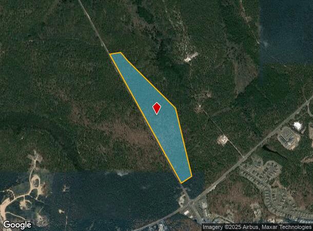
513 Route 539
Lakewood-New Brunswick, NJ
36.40AC DEDICATED OPEN SPACE
19-00079-0000-00052
Ocean
Governmentalpublicusegeneral
New Jersey
X
52
34029C0260F
36.40 AC
0
Ocean County
2025
Northern New Jersey
739100
DEMOGRAPHICS near 513 Route 539
1 Mile
3 Mile
5 Mile
2024 Total Population
1,391
11,413
17,384
2029 Population
1,501
11,905
18,054
Pop Growth 2024-2029
+ 7.91%
+ 4.31%
+ 3.85%
Average Age
62
63
62
2024 Total Households
793
6,743
9,828
HH Growth 2024-2029
+ 7.44%
+ 3.07%
+ 2.60%
Median Household Inc
$46,404
$35,855
$39,112
Avg Household Size
1.70
1.60
1.70
2024 Avg HH Vehicles
1.00
1.00
1.00
Median Home Value
$93,661
$83,114
$83,739
Median Year Built
1976
1976
1977
Nearby Places
Map Layers
Map Styles
 Street
 Aerial
- Restaurants
- Banks
- Shops
- Fitness
- Groceries
SALE & LEASE HISTORY
LISTING DATE
SALE/LEASE

Sep 24, 2016
For Sale
Jun 25, 2020
For Sale
Nearby Properties
Address
Land Use
TOTAL SIZE
Lot Size
Zoning
Address
Land Use
TOTAL SIZE
Lot Size
Zoning
1,638 SF
177.65 AC
WTRC
Address
Land Use
TOTAL SIZE
Lot Size
Zoning
179.01 AC
RC
Address
Land Use
TOTAL SIZE
Lot Size
Zoning
126.21 AC
RC
Address
Land Use
TOTAL SIZE
Lot Size
Zoning
64.16 AC
RC
Address
Land Use
TOTAL SIZE
Lot Size
Zoning
39.46 AC
WTRC
Address
Land Use
TOTAL SIZE
Lot Size
Zoning
278 SF
55.93 AC
WTRC
Address
Land Use
TOTAL SIZE
Lot Size
Zoning
63,330 SF
30.02 AC
WTRA
Address
Land Use
TOTAL SIZE
Lot Size
Zoning
50.82 AC
RC
Address
Land Use
TOTAL SIZE
Lot Size
Zoning
7,664 SF
192.40 AC
WTRA
Address
Land Use
TOTAL SIZE
Lot Size
Zoning
66.19 AC
RC
Address
Land Use
TOTAL SIZE
Lot Size
Zoning
54.09 AC
WTRC
Address
Land Use
TOTAL SIZE
Lot Size
Zoning
19,380 SF
53.81 AC
RC
Address
Land Use
TOTAL SIZE
Lot Size
Zoning
13,499 SF
51.86 AC
WTRC
Address
Land Use
TOTAL SIZE
Lot Size
Zoning
163 SF
18.96 AC
WTRA
Address
Land Use
TOTAL SIZE
Lot Size
Zoning
92,090 SF
17.22 AC
WTHD
Address
Land Use
TOTAL SIZE
Lot Size
Zoning
3,619.50 AC
MI
Address
Land Use
TOTAL SIZE
Lot Size
Zoning
39.46 AC
WTRC
Address
Land Use
TOTAL SIZE
Lot Size
Zoning
28.40 AC
WTRC
Address
Land Use
TOTAL SIZE
Lot Size
Zoning
4,752 SF
10.33 AC
WTRC
Address
Land Use
TOTAL SIZE
Lot Size
Zoning
5.37 AC
WTRC
Address
Land Use
TOTAL SIZE
Lot Size
Zoning
8.52 AC
WTRC
Address
Land Use
TOTAL SIZE
Lot Size
Zoning
38,079 SF
14.46 AC
WTRC
Address
Land Use
TOTAL SIZE
Lot Size
Zoning
1,576.30 AC
PPA
Address
Land Use
TOTAL SIZE
Lot Size
Zoning
5,445 SF
4.05 AC
WTHD
Address
Land Use
TOTAL SIZE
Lot Size
Zoning
5 AC
WTRC
Address
Land Use
TOTAL SIZE
Lot Size
Zoning
12,705 SF
3.32 AC
WTHD
Address
Land Use
TOTAL SIZE
Lot Size
Zoning
9,836 SF
13.95 AC
WTHD
Address
Land Use
TOTAL SIZE
Lot Size
Zoning
1.16 AC
FA-S
Address
Land Use
TOTAL SIZE
Lot Size
Zoning
11.98 AC
WTRC
Address
Land Use
TOTAL SIZE
Lot Size
Zoning
2,102 SF
26.08 AC
BV40
The World's #1 Commercial Real Estate Marketplace
Connect with us
© 2026 CoStar Group
The information above has been obtained from sources believed reliable. While we do not doubt its accuracy we have not verified it and make no guarantee, warranty or representation about it. It is your responsibility to independently confirm its accuracy and completeness. Any projections, opinions, assumptions, or estimates used are for example only and do not represent the current or future performance of the property. The value of this transaction to you depends on tax and other factors which should be evaluated by your tax, financial, and legal advisors. You and your advisors should conduct a careful, independent investigation of the property to determine to your satisfaction the suitability of the property for your needs.