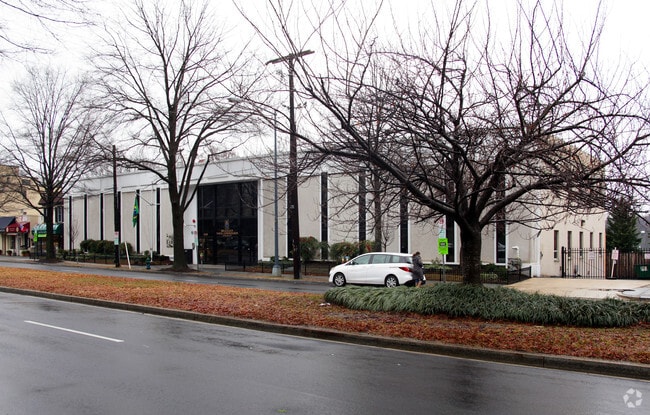
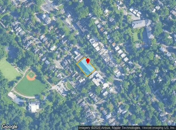
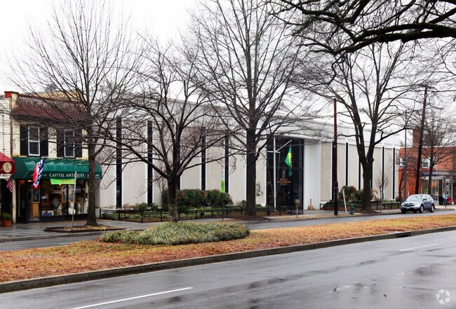
Property Record
5130 Macarthur Blvd Nw, Washington, DC 20016
NEARBY LISTINGS FOR SALE OR LEASE
Property Detail
5130 Macarthur Blvd Nw
Washington-Arlington-Alexandria, DC-VA-MD-WV
Palisades
1418-0062
SQUARE 1418 LOT 0062 NBHD: PALISADES
Taxexempt
District of Columbia
X
District of Columbia
51013C0036D
62
0
0.46 AC
2025
Uptown
000902
Washington, DC
38,100 SF
DEMOGRAPHICS near 5130 Macarthur Blvd Nw
1 Mile
3 Mile
5 Mile
2024 Total Population
8,250
193,852
603,844
2029 Population
7,449
183,971
572,008
Pop Growth 2024-2029
(9.71%)
(5.10%)
(5.27%)
Average Age
41
40
39
2024 Total Households
2,826
90,837
275,067
HH Growth 2024-2029
(10.62%)
(5.69%)
(6.02%)
Median Household Inc
$241,325
$145,612
$131,170
Avg Household Size
2.60
2.10
2.10
2024 Avg HH Vehicles
2.00
1.00
1.00
Median Home Value
$1,112,343
$1,008,755
$900,623
Median Year Built
1954
1964
1963
Nearby Places
Map Layers
Map Styles
 Street
 Aerial
- Restaurants
- Banks
- Shops
- Fitness
- Groceries
PUBLIC TRANSPORTATION
COMMUTER RAIL
4 (Fredericksburg Line - Virginia Railway Express, Manassas Line - Virginia Railway Express)
DRIVE
WALK
Distance
4 (Fredericksburg Line - Virginia Railway Express, Manassas Line - Virginia Railway Express)
11 min
6.3 mi
L'enfant (Fredericksburg Line - Virginia Railway Express, Manassas Line - Virginia Railway Express)
DRIVE
WALK
Distance
L'enfant (Fredericksburg Line - Virginia Railway Express, Manassas Line - Virginia Railway Express)
11 min
6.3 mi
AIRPORT
Ronald Reagan Washington Ntl
DRIVE
WALK
Distance
Ronald Reagan Washington Ntl
16 min
7.9 mi
Washington Dulles International
DRIVE
WALK
Distance
Washington Dulles International
39 min
22.0 mi
Baltimore/Washington International Thurgood Marshall
DRIVE
WALK
Distance
Baltimore/Washington International Thurgood Marshall
55 min
38.6 mi
Freight Ports
Port of Baltimore
DRIVE
WALK
Distance
Port of Baltimore
59 min
41.4 mi
Nearby Properties
Address
Land Use
TOTAL SIZE
Lot Size
Zoning
Address
Land Use
TOTAL SIZE
Lot Size
Zoning
553,914 SF
55.91 AC
R-1B
Address
Land Use
TOTAL SIZE
Lot Size
Zoning
900,000 SF
12.60 AC
RA-4
Address
Land Use
TOTAL SIZE
Lot Size
Zoning
77.26 AC
R-3/GT
Address
Land Use
TOTAL SIZE
Lot Size
Zoning
636,768 SF
1.91 AC
C-O-ROSSLY
Address
Land Use
TOTAL SIZE
Lot Size
Zoning
247,900 SF
170.58 AC
RA-2;UNZON
Address
Land Use
TOTAL SIZE
Lot Size
Zoning
20.19 AC
S-3A/S-D
Address
Land Use
TOTAL SIZE
Lot Size
Zoning
Address
Land Use
TOTAL SIZE
Lot Size
Zoning
45,523 SF
0.24 AC
C-O-ROSSLY
Address
Land Use
TOTAL SIZE
Lot Size
Zoning
795,214 SF
MU-5A
Address
Land Use
TOTAL SIZE
Lot Size
Zoning
4.67 AC
MU-13;MU-1
Address
Land Use
TOTAL SIZE
Lot Size
Zoning
3,046,518 SF
257.86 AC
110
Address
Land Use
TOTAL SIZE
Lot Size
Zoning
997,890 SF
6.30 AC
CR3.0
Address
Land Use
TOTAL SIZE
Lot Size
Zoning
580,759 SF
0.69 AC
C-O/C-O-RO
Address
Land Use
TOTAL SIZE
Lot Size
Zoning
633,810 SF
3.45 AC
RA-H-3.2
Address
Land Use
TOTAL SIZE
Lot Size
Zoning
591,243 SF
1.90 AC
RA-H-3.2
Address
Land Use
TOTAL SIZE
Lot Size
Zoning
1,452,667 SF
43.94 AC
R-1B;RA-1
Address
Land Use
TOTAL SIZE
Lot Size
Zoning
597,364 SF
1.66 AC
C-O/C-O-2.
Address
Land Use
TOTAL SIZE
Lot Size
Zoning
10,158 SF
97.34 AC
MU-10;MU-1
Address
Land Use
TOTAL SIZE
Lot Size
Zoning
902,764 SF
2.87 AC
MU-5A
Address
Land Use
TOTAL SIZE
Lot Size
Zoning
12,786 SF
2.19 AC
C-2
Address
Land Use
TOTAL SIZE
Lot Size
Zoning
1,180,000 SF
35.70 AC
R90
Address
Land Use
TOTAL SIZE
Lot Size
Zoning
354,000 SF
0.67 AC
C-O-ROSSLY
Address
Land Use
TOTAL SIZE
Lot Size
Zoning
528 SF
296.59 AC
MU-11;MU-1
Address
Land Use
TOTAL SIZE
Lot Size
Zoning
12,635 SF
1.75 AC
RA4.8
Address
Land Use
TOTAL SIZE
Lot Size
Zoning
1,600 SF
1.92 AC
RA6-15/RC
Address
Land Use
TOTAL SIZE
Lot Size
Zoning
244,615 SF
19.61 AC
R-1A/FH
Address
Land Use
TOTAL SIZE
Lot Size
Zoning
69.17 AC
R-1B
The World's #1 Commercial Real Estate Marketplace
Connect with us
© 2025 CoStar Group
The information above has been obtained from sources believed reliable. While we do not doubt its accuracy we have not verified it and make no guarantee, warranty or representation about it. It is your responsibility to independently confirm its accuracy and completeness. Any projections, opinions, assumptions, or estimates used are for example only and do not represent the current or future performance of the property. The value of this transaction to you depends on tax and other factors which should be evaluated by your tax, financial, and legal advisors. You and your advisors should conduct a careful, independent investigation of the property to determine to your satisfaction the suitability of the property for your needs.