Property Record
5134 N Murphy Rd, Stanfield, AZ 85172
Property Detail
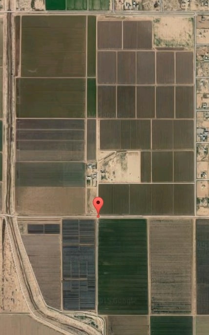
5134 N Murphy Rd
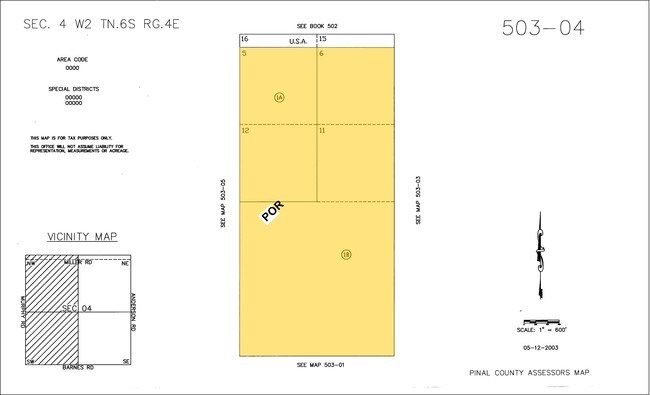
503-05-001B
GOVT LOTS 13 8 9 & E PRT GOVT LOTS 7 10 & NE PT GOVT LOTS 14 PLUS S1/2 OF SEC 5 LESS SM PCL SE COR S1/2 OF SEC 5-6S-4E EXC W-2936' + OR - OF S1/2 OF SAID SEC 5-6S-4E 295.07 AC
Farms
PINAL
GR
Arizona
A Areas with a 1% annual chance of flooding and a 26% chance of flooding over the life of a 30-year mortgage.
13
2024
9.52 AC
2025
Pinal County
941402
Phoenix
3,635 SF
Phoenix-Mesa-Chandler, AZ
NEARBY LISTINGS FOR SALE OR LEASE
DEMOGRAPHICS near 5134 N Murphy Rd
1 mile
3 mile
5 mile
2025 Total Population
407
582
943
2030 Population
438
627
1,041
Pop Growth 2025-2030
+ 7.62%
+ 7.73%
+ 10.39%
Average Age
37
37
38
2025 Total Households
121
173
290
HH Growth 2025-2030
+ 7.44%
+ 7.51%
+ 10.34%
Median Household Inc
$65,625
$62,500
$70,908
Avg Household Size
3.50
3.50
3.20
2025 Avg HH Vehicles
2.00
2.00
2.00
Median Home Value
$604,166
$588,235
$398,213
Median Year Built
1986
1986
1988
Nearby Places
Map Layers
Map Styles
 Street
 Aerial
Layers
 Traffic
 Biking
Places
Listings with unknown addresses are not visible on the map
- Restaurants
- Banks
- Shops
- Fitness
- Groceries
SALE & LEASE HISTORY
LISTING DATE
SALE/LEASE

Sep 24, 2016
For Sale
Nearby Properties
Address
Land Use
TOTAL SIZE
Lot Size
Zoning
Address
Land Use
TOTAL SIZE
Lot Size
Zoning
34,415 SF
880 AC
Address
Land Use
TOTAL SIZE
Lot Size
Zoning
5,280 SF
1,015.45 AC
CI1
Address
Land Use
TOTAL SIZE
Lot Size
Zoning
1,524 SF
672.18 AC
CR3
Address
Land Use
TOTAL SIZE
Lot Size
Zoning
4,734 SF
280 AC
Address
Land Use
TOTAL SIZE
Lot Size
Zoning
1,200 SF
320 AC
Address
Land Use
TOTAL SIZE
Lot Size
Zoning
9,000 SF
28.70 AC
GR
Address
Land Use
TOTAL SIZE
Lot Size
Zoning
293.57 AC
CR3
Address
Land Use
TOTAL SIZE
Lot Size
Zoning
12,080 SF
21.93 AC
GR
Address
Land Use
TOTAL SIZE
Lot Size
Zoning
10,000 SF
5.32 AC
GR
Address
Land Use
TOTAL SIZE
Lot Size
Zoning
272.87 AC
GR
Address
Land Use
TOTAL SIZE
Lot Size
Zoning
320 AC
Address
Land Use
TOTAL SIZE
Lot Size
Zoning
320 AC
Address
Land Use
TOTAL SIZE
Lot Size
Zoning
150 AC
GR
Address
Land Use
TOTAL SIZE
Lot Size
Zoning
Address
Land Use
TOTAL SIZE
Lot Size
Zoning
6,956 SF
3.50 AC
Address
Land Use
TOTAL SIZE
Lot Size
Zoning
153.70 AC
GR
Address
Land Use
TOTAL SIZE
Lot Size
Zoning
198.08 AC
CR3
Address
Land Use
TOTAL SIZE
Lot Size
Zoning
180.41 AC
CR3
Address
Land Use
TOTAL SIZE
Lot Size
Zoning
178.10 AC
GR
Address
Land Use
TOTAL SIZE
Lot Size
Zoning
880 SF
160 AC
CR3
Address
Land Use
TOTAL SIZE
Lot Size
Zoning
159.68 AC
GR
Address
Land Use
TOTAL SIZE
Lot Size
Zoning
146.37 AC
CR3
The World's #1 Commercial Real Estate Marketplace
Connect with us
© 2026 CoStar Group
The information above has been obtained from sources believed reliable. While we do not doubt its accuracy we have not verified it and make no guarantee, warranty or representation about it. It is your responsibility to independently confirm its accuracy and completeness. Any projections, opinions, assumptions, or estimates used are for example only and do not represent the current or future performance of the property. The value of this transaction to you depends on tax and other factors which should be evaluated by your tax, financial, and legal advisors. You and your advisors should conduct a careful, independent investigation of the property to determine to your satisfaction the suitability of the property for your needs.