Property Record
5135 E 76Th St N, Sperry, OK 74073

Save to a Folder
{{folder.Name}}
{{folder.ListingIds.length}} Properties
{{folder.ListingIds.length}} Property
Create a New Folder
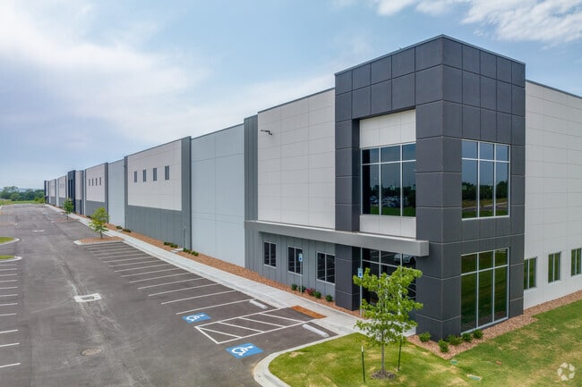
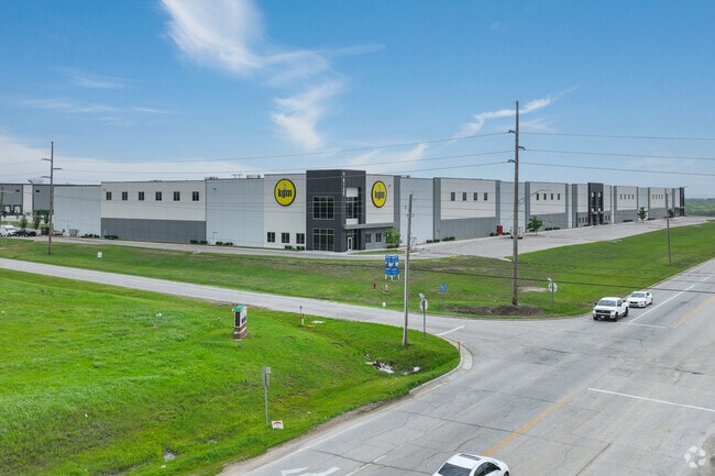
Property Detail
5135 E 76Th St N
57346-13-27-59350
LOT 2 BLOCK 1
Warehouse
TULSA
IM
Oklahoma
B and X Area of moderate flood hazard, usually the area between the limits of the 100-year and 500-year floods.
2
2025
16.77 AC
2025
Northeast Tulsa
005600
Tulsa
229,485 SF
Tulsa, OK
NEARBY LISTINGS FOR SALE OR LEASE
DEMOGRAPHICS near 5135 E 76Th St N
1 mile
3 mile
5 mile
2025 Total Population
208
6,337
41,497
2030 Population
221
6,730
43,277
Pop Growth 2025-2030
+ 6.25%
+ 6.20%
+ 4.29%
Average Age
40
40
38
2025 Total Households
75
2,316
15,487
HH Growth 2025-2030
+ 5.33%
+ 6.30%
+ 4.29%
Median Household Inc
$91,666
$81,290
$58,828
Avg Household Size
2.80
2.70
2.60
2025 Avg HH Vehicles
2.00
2.00
2.00
Median Home Value
$346,666
$338,461
$214,698
Median Year Built
2010
2000
1982
Nearby Places
Map Layers
Map Styles
 Street
 Aerial
Layers
 Traffic
 Biking
Places
Listings with unknown addresses are not visible on the map
- Restaurants
- Banks
- Shops
- Fitness
- Groceries
PUBLIC TRANSPORTATION
AIRPORT
Tulsa International
Drive
Walk
Distance
Tulsa International
14 min
8.6 mi
Freight Ports
Tulsa Port Of Catoosa
Drive
Walk
Distance
Tulsa Port Of Catoosa
20 min
13.3 mi
SALE & LEASE HISTORY
LISTING DATE
SALE/LEASE

Mar 29, 2022
For Lease
Nearby Properties
Address
Land Use
TOTAL SIZE
Lot Size
Zoning
Address
Land Use
TOTAL SIZE
Lot Size
Zoning
3,235,512 SF
71.56 AC
IM
Address
Land Use
TOTAL SIZE
Lot Size
Zoning
873,896 SF
50 AC
IM
Address
Land Use
TOTAL SIZE
Lot Size
Zoning
209,620 SF
19.59 AC
IM
Address
Land Use
TOTAL SIZE
Lot Size
Zoning
429,912 SF
59.57 AC
IM
Address
Land Use
TOTAL SIZE
Lot Size
Zoning
65,354 SF
41.54 AC
AG
Address
Land Use
TOTAL SIZE
Lot Size
Zoning
63,108 SF
33.82 AC
AG
Address
Land Use
TOTAL SIZE
Lot Size
Zoning
457,823 SF
25.72 AC
IM
Address
Land Use
TOTAL SIZE
Lot Size
Zoning
67,909 SF
48.73 AC
IM
Address
Land Use
TOTAL SIZE
Lot Size
Zoning
16,196 SF
9.73 AC
IL
Address
Land Use
TOTAL SIZE
Lot Size
Zoning
859,108 SF
86.24 AC
IM
Address
Land Use
TOTAL SIZE
Lot Size
Zoning
32,300 SF
20.88 AC
NCU
Address
Land Use
TOTAL SIZE
Lot Size
Zoning
133,467 SF
11.37 AC
CS
Address
Land Use
TOTAL SIZE
Lot Size
Zoning
5,670 SF
96.05 AC
AG
Address
Land Use
TOTAL SIZE
Lot Size
Zoning
473,599 SF
56.42 AC
IM
Address
Land Use
TOTAL SIZE
Lot Size
Zoning
419,821 SF
38.38 AC
IM
Address
Land Use
TOTAL SIZE
Lot Size
Zoning
29,065 SF
111.30 AC
RS
Address
Land Use
TOTAL SIZE
Lot Size
Zoning
6,800 SF
347.73 AC
RS3
Address
Land Use
TOTAL SIZE
Lot Size
Zoning
9,566 SF
8.26 AC
IL
Address
Land Use
TOTAL SIZE
Lot Size
Zoning
137,320 SF
40.12 AC
IM
Address
Land Use
TOTAL SIZE
Lot Size
Zoning
83,000 SF
10.51 AC
IM
Address
Land Use
TOTAL SIZE
Lot Size
Zoning
175,614 SF
33.58 AC
IM
Address
Land Use
TOTAL SIZE
Lot Size
Zoning
1 SF
228.69 AC
AG
Address
Land Use
TOTAL SIZE
Lot Size
Zoning
14,836 SF
9.39 AC
AGR
Address
Land Use
TOTAL SIZE
Lot Size
Zoning
85,489 SF
17.99 AC
IM
Address
Land Use
TOTAL SIZE
Lot Size
Zoning
13.64 AC
O
Address
Land Use
TOTAL SIZE
Lot Size
Zoning
1,200 SF
38.79 AC
AG
Address
Land Use
TOTAL SIZE
Lot Size
Zoning
136,660 SF
29.88 AC
IM
Address
Land Use
TOTAL SIZE
Lot Size
Zoning
108,900 SF
9.84 AC
IM
Address
Land Use
TOTAL SIZE
Lot Size
Zoning
7,129 SF
4.15 AC
IM
The World's #1 Commercial Real Estate Marketplace
Connect with us
© 2026 CoStar Group
The information above has been obtained from sources believed reliable. While we do not doubt its accuracy we have not verified it and make no guarantee, warranty or representation about it. It is your responsibility to independently confirm its accuracy and completeness. Any projections, opinions, assumptions, or estimates used are for example only and do not represent the current or future performance of the property. The value of this transaction to you depends on tax and other factors which should be evaluated by your tax, financial, and legal advisors. You and your advisors should conduct a careful, independent investigation of the property to determine to your satisfaction the suitability of the property for your needs.