Property Record
5137 Jean Duluth Rd, Duluth, MN 55803

Save to a Folder
{{folder.Name}}
{{folder.ListingIds.length}} Properties
{{folder.ListingIds.length}} Property
Create a New Folder
Property Detail
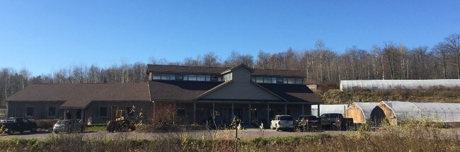
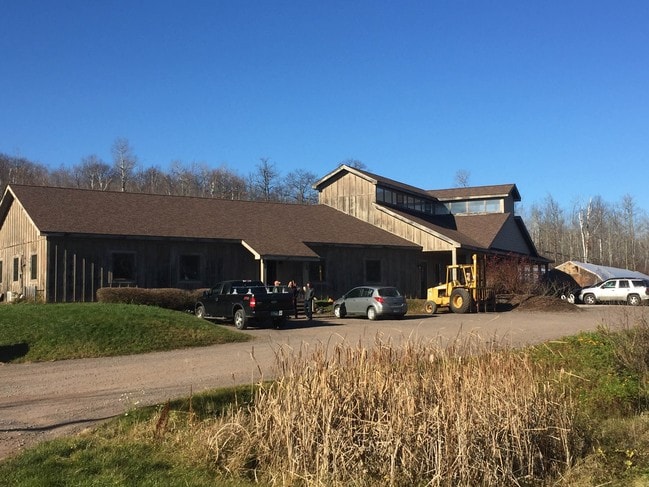
5137 Jean Duluth Rd
520001602070
N1/2 OF SE1/4 OF SE1/4 SERIAL #
Commercialnec
Saint Louis
LIU
Minnesota
B and X Area of moderate flood hazard, usually the area between the limits of the 100-year and 500-year floods.
20 AC
2026
South St Louis County
2024
Duluth
010400
Duluth, MN-WI
8,200 SF
NEARBY LISTINGS FOR SALE OR LEASE
-
-
View all Duluth listings for sale on LoopNet.com
DEMOGRAPHICS near 5137 Jean Duluth Rd
1 mile
3 mile
5 mile
2025 Total Population
348
6,098
29,101
2030 Population
343
5,973
28,655
Pop Growth 2025-2030
(1.44%)
(2.05%)
(1.53%)
Average Age
43
42
40
2025 Total Households
137
2,435
10,887
HH Growth 2025-2030
(1.46%)
(2.05%)
(1.63%)
Median Household Inc
$95,624
$101,000
$100,907
Avg Household Size
2.50
2.40
2.40
2025 Avg HH Vehicles
2.00
2.00
2.00
Median Home Value
$325,714
$292,272
$306,828
Median Year Built
1973
1960
1955
Nearby Places
Map Layers
Map Styles
 Street
 Aerial
Layers
 Traffic
 Biking
Places
Listings with unknown addresses are not visible on the map
- Restaurants
- Banks
- Shops
- Fitness
- Groceries
PUBLIC TRANSPORTATION
AIRPORT
Duluth International
Drive
Walk
Distance
Duluth International
30 min
13.3 mi
SALE & LEASE HISTORY
LISTING DATE
SALE/LEASE

Nov 21, 2016
For Sale
Nearby Properties
Address
Land Use
TOTAL SIZE
Lot Size
Zoning
Address
Land Use
TOTAL SIZE
Lot Size
Zoning
39,615 SF
1.73 AC
Address
Land Use
TOTAL SIZE
Lot Size
Zoning
41,499 SF
8.03 AC
Address
Land Use
TOTAL SIZE
Lot Size
Zoning
58,756 SF
126.18 AC
Address
Land Use
TOTAL SIZE
Lot Size
Zoning
36,032 SF
34.98 AC
Address
Land Use
TOTAL SIZE
Lot Size
Zoning
53,471 SF
11.21 AC
R4
Address
Land Use
TOTAL SIZE
Lot Size
Zoning
29,520 SF
0.58 AC
Address
Land Use
TOTAL SIZE
Lot Size
Zoning
23,370 SF
80 AC
Address
Land Use
TOTAL SIZE
Lot Size
Zoning
31,845 SF
1.45 AC
Address
Land Use
TOTAL SIZE
Lot Size
Zoning
5,600 SF
7.06 AC
Address
Land Use
TOTAL SIZE
Lot Size
Zoning
576 SF
1.54 AC
Address
Land Use
TOTAL SIZE
Lot Size
Zoning
364 SF
4.44 AC
Address
Land Use
TOTAL SIZE
Lot Size
Zoning
330 SF
2.50 AC
Address
Land Use
TOTAL SIZE
Lot Size
Zoning
16,236 SF
0.70 AC
C1
Address
Land Use
TOTAL SIZE
Lot Size
Zoning
5,244 SF
7.73 AC
MUNS
Address
Land Use
TOTAL SIZE
Lot Size
Zoning
2,892 SF
0.79 AC
Address
Land Use
TOTAL SIZE
Lot Size
Zoning
4,700 SF
0.80 AC
Address
Land Use
TOTAL SIZE
Lot Size
Zoning
840 SF
0.52 AC
LIU
Address
Land Use
TOTAL SIZE
Lot Size
Zoning
13,652 SF
0.69 AC
Address
Land Use
TOTAL SIZE
Lot Size
Zoning
14,688 SF
0.47 AC
COM
Address
Land Use
TOTAL SIZE
Lot Size
Zoning
7,871 SF
0.99 AC
LIU
Address
Land Use
TOTAL SIZE
Lot Size
Zoning
11,062 SF
0.50 AC
RES
Address
Land Use
TOTAL SIZE
Lot Size
Zoning
2,622 SF
0.41 AC
Address
Land Use
TOTAL SIZE
Lot Size
Zoning
2,176 SF
0.22 AC
Address
Land Use
TOTAL SIZE
Lot Size
Zoning
2,956 SF
30 AC
MUNS
Address
Land Use
TOTAL SIZE
Lot Size
Zoning
20,991 SF
2.14 AC
LIU
Address
Land Use
TOTAL SIZE
Lot Size
Zoning
12,028 SF
0.13 AC
C1
Address
Land Use
TOTAL SIZE
Lot Size
Zoning
6,560 SF
1.09 AC
LIU
Address
Land Use
TOTAL SIZE
Lot Size
Zoning
288 SF
100 AC
Address
Land Use
TOTAL SIZE
Lot Size
Zoning
5,600 SF
4.55 AC
COM
The World's #1 Commercial Real Estate Marketplace
Connect with us
© 2026 CoStar Group
The information above has been obtained from sources believed reliable. While we do not doubt its accuracy we have not verified it and make no guarantee, warranty or representation about it. It is your responsibility to independently confirm its accuracy and completeness. Any projections, opinions, assumptions, or estimates used are for example only and do not represent the current or future performance of the property. The value of this transaction to you depends on tax and other factors which should be evaluated by your tax, financial, and legal advisors. You and your advisors should conduct a careful, independent investigation of the property to determine to your satisfaction the suitability of the property for your needs.