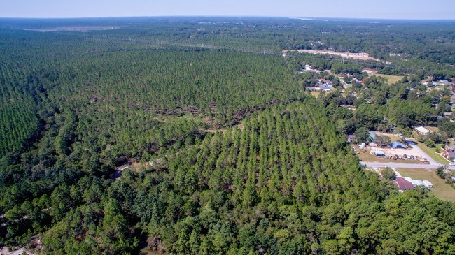
Property Record
5138 Salvation St, Panama City, FL 32404

NEARBY LISTINGS FOR SALE OR LEASE
Property Detail
5138 Salvation St
05894-000-001
10 3S 13W -1A- 143D S1/2 OF N1/2 LESS W 13 CHAINS & LESS E 13.35 CHAINS ORB 4487 P 1289
Vacantlandnec
Bay
AE
Florida
12005C0356H
62.76 AC
2024
Panama City
2025
Other Market Areas
000500
Panama City-Panama City Beach, FL
DEMOGRAPHICS near 5138 Salvation St
1 Mile
3 Mile
5 Mile
2024 Total Population
1,803
6,841
16,817
2029 Population
1,941
7,343
18,003
Pop Growth 2024-2029
+ 7.65%
+ 7.34%
+ 7.05%
Average Age
38
39
40
2024 Total Households
546
2,059
5,531
HH Growth 2024-2029
+ 8.24%
+ 7.72%
+ 7.45%
Median Household Inc
$70,473
$72,483
$76,183
Avg Household Size
2.80
2.80
2.70
2024 Avg HH Vehicles
2.00
2.00
2.00
Median Home Value
$180,722
$222,897
$242,146
Median Year Built
1998
1997
1995
Nearby Places
Map Layers
Map Styles
 Street
 Aerial
- Restaurants
- Banks
- Shops
- Fitness
- Groceries
PUBLIC TRANSPORTATION
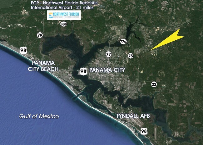
AIRPORT
Northwest Florida Beaches International
DRIVE
WALK
Distance
Northwest Florida Beaches International
34 min
21.4 mi
Freight Ports
Port of Panama City
DRIVE
WALK
Distance
Port of Panama City
24 min
13.6 mi
SALE & LEASE HISTORY
LISTING DATE
SALE/LEASE

Sep 24, 2016
For Sale
Nearby Properties
Address
Land Use
TOTAL SIZE
Lot Size
Zoning
Address
Land Use
TOTAL SIZE
Lot Size
Zoning
271,159 SF
24.36 AC
PC16
Address
Land Use
TOTAL SIZE
Lot Size
Zoning
250,600 SF
33.22 AC
PC18
Address
Land Use
TOTAL SIZE
Lot Size
Zoning
256,460 SF
100 AC
BC13
Address
Land Use
TOTAL SIZE
Lot Size
Zoning
150,080 SF
3.44 AC
PC18
Address
Land Use
TOTAL SIZE
Lot Size
Zoning
123,392 SF
15 AC
BC14
Address
Land Use
TOTAL SIZE
Lot Size
Zoning
100,320 SF
2.42 AC
PC18
Address
Land Use
TOTAL SIZE
Lot Size
Zoning
75,725 SF
4.58 AC
Address
Land Use
TOTAL SIZE
Lot Size
Zoning
108,544 SF
35.95 AC
PI
Address
Land Use
TOTAL SIZE
Lot Size
Zoning
73,525 SF
31.39 AC
BC13
Address
Land Use
TOTAL SIZE
Lot Size
Zoning
60,009 SF
7.79 AC
PC18
Address
Land Use
TOTAL SIZE
Lot Size
Zoning
80,004 SF
10 AC
BC14
Address
Land Use
TOTAL SIZE
Lot Size
Zoning
76,921 SF
12 AC
BC06
Address
Land Use
TOTAL SIZE
Lot Size
Zoning
65,790 SF
3.01 AC
BC13
Address
Land Use
TOTAL SIZE
Lot Size
Zoning
157,290 SF
14 AC
BC13
Address
Land Use
TOTAL SIZE
Lot Size
Zoning
37,225 SF
154.53 AC
BC14
Address
Land Use
TOTAL SIZE
Lot Size
Zoning
330.52 AC
Address
Land Use
TOTAL SIZE
Lot Size
Zoning
10,324 SF
238.95 AC
BC14
Address
Land Use
TOTAL SIZE
Lot Size
Zoning
52,570 SF
3.31 AC
BC13
Address
Land Use
TOTAL SIZE
Lot Size
Zoning
12,948 SF
238.33 AC
BC14
Address
Land Use
TOTAL SIZE
Lot Size
Zoning
18,125 SF
18 AC
AG2
Address
Land Use
TOTAL SIZE
Lot Size
Zoning
41,974 SF
8.61 AC
BC13
Address
Land Use
TOTAL SIZE
Lot Size
Zoning
15,325 SF
10 AC
BC13
Address
Land Use
TOTAL SIZE
Lot Size
Zoning
35,400 SF
3.40 AC
BC05
Address
Land Use
TOTAL SIZE
Lot Size
Zoning
12,966 SF
9.79 AC
BC13
Address
Land Use
TOTAL SIZE
Lot Size
Zoning
15,900 SF
6.19 AC
BC06
Address
Land Use
TOTAL SIZE
Lot Size
Zoning
49,336 SF
3.20 AC
BC13
Address
Land Use
TOTAL SIZE
Lot Size
Zoning
12,476 SF
5.25 AC
PI
Address
Land Use
TOTAL SIZE
Lot Size
Zoning
8,123 SF
0.94 AC
BC16
Address
Land Use
TOTAL SIZE
Lot Size
Zoning
3,626 SF
3.19 AC
BC05
Address
Land Use
TOTAL SIZE
Lot Size
Zoning
23,750 SF
2.43 AC
BC05
The World's #1 Commercial Real Estate Marketplace
Connect with us
© 2026 CoStar Group
The information above has been obtained from sources believed reliable. While we do not doubt its accuracy we have not verified it and make no guarantee, warranty or representation about it. It is your responsibility to independently confirm its accuracy and completeness. Any projections, opinions, assumptions, or estimates used are for example only and do not represent the current or future performance of the property. The value of this transaction to you depends on tax and other factors which should be evaluated by your tax, financial, and legal advisors. You and your advisors should conduct a careful, independent investigation of the property to determine to your satisfaction the suitability of the property for your needs.