Property Record
514 E King Rd, Malvern, PA 19355

Save to a Folder
{{folder.Name}}
{{folder.ListingIds.length}} Properties
{{folder.ListingIds.length}} Property
Create a New Folder
Property Detail
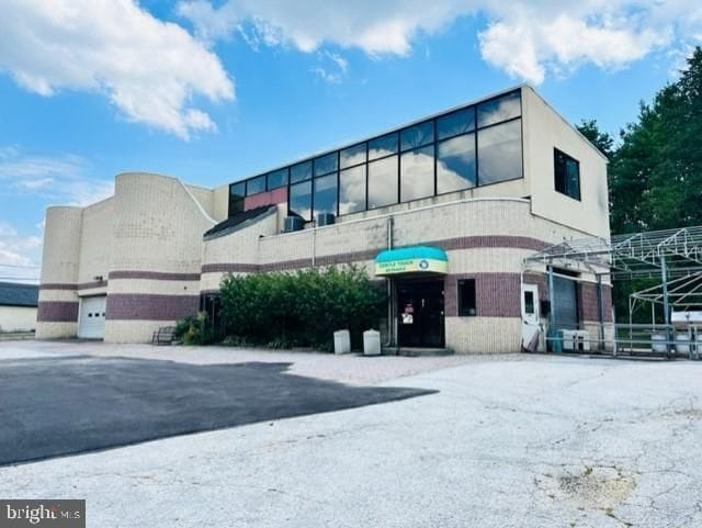
514 E King Rd
54-01P-0183.0000
1.3 AC & CAR WASH
Autorepair
CHESTER
HB
Pennsylvania
B and X Area of moderate flood hazard, usually the area between the limits of the 100-year and 500-year floods.
1.30 AC
2026
Upper Main Line
2026
Philadelphia
302103
Philadelphia-Camden-Wilmington, PA-NJ-DE-MD
7,456 SF
NEARBY LISTINGS FOR SALE OR LEASE
DEMOGRAPHICS near 514 E King Rd
1 mile
3 mile
5 mile
2025 Total Population
7,606
36,052
93,780
2030 Population
7,894
37,378
97,743
Pop Growth 2025-2030
+ 3.79%
+ 3.68%
+ 4.23%
Average Age
43
43
43
2025 Total Households
3,225
13,978
35,458
HH Growth 2025-2030
+ 3.78%
+ 3.80%
+ 4.24%
Median Household Inc
$120,049
$156,186
$151,546
Avg Household Size
2.30
2.50
2.50
2025 Avg HH Vehicles
2.00
2.00
2.00
Median Home Value
$499,843
$698,569
$712,930
Median Year Built
1959
1975
1979
Nearby Places
Map Layers
Map Styles
 Street
 Aerial
Layers
 Traffic
 Biking
Places
Listings with unknown addresses are not visible on the map
- Restaurants
- Banks
- Shops
- Fitness
- Groceries
PUBLIC TRANSPORTATION
TRANSIT/SUBWAY
Malvern (R5 - Southeastern Pennsylvania Transportation Authority Regional Rail (SEPTA Regional Rail))
Drive
Walk
Distance
Malvern (R5 - Southeastern Pennsylvania Transportation Authority Regional Rail (SEPTA Regional Rail))
3 min
20 min
1.0 mi
COMMUTER RAIL
Paoli (R5 - Southeastern Pennsylvania Transportation Authority Regional Rail (SEPTA Regional Rail))
Drive
Walk
Distance
Paoli (R5 - Southeastern Pennsylvania Transportation Authority Regional Rail (SEPTA Regional Rail))
3 min
0.9 mi
Malvern (R5 - Southeastern Pennsylvania Transportation Authority Regional Rail (SEPTA Regional Rail))
Drive
Walk
Distance
Malvern (R5 - Southeastern Pennsylvania Transportation Authority Regional Rail (SEPTA Regional Rail))
3 min
20 min
1.0 mi
AIRPORT
Philadelphia International
Drive
Walk
Distance
Philadelphia International
42 min
22.9 mi
Freight Ports
South Jersey Port
Drive
Walk
Distance
South Jersey Port
45 min
28.7 mi
SALE & LEASE HISTORY
LISTING DATE
SALE/LEASE

Feb 16, 2022
For Sale
Dec 20, 2022
For Sale
Dec 08, 2020
For Sale
Nearby Properties
Address
Land Use
TOTAL SIZE
Lot Size
Zoning
Address
Land Use
TOTAL SIZE
Lot Size
Zoning
887,909 SF
22.50 AC
I
Address
Land Use
TOTAL SIZE
Lot Size
Zoning
692,847 SF
84.22 AC
GI
Address
Land Use
TOTAL SIZE
Lot Size
Zoning
1,173,683 SF
56.30 AC
LI
Address
Land Use
TOTAL SIZE
Lot Size
Zoning
615,910 SF
24.84 AC
C1
Address
Land Use
TOTAL SIZE
Lot Size
Zoning
921,976 SF
111 AC
PO1
Address
Land Use
TOTAL SIZE
Lot Size
Zoning
451,865 SF
19.90 AC
R2
Address
Land Use
TOTAL SIZE
Lot Size
Zoning
447,886 SF
13.17 AC
C1
Address
Land Use
TOTAL SIZE
Lot Size
Zoning
268,392 SF
13.73 AC
RIC
Address
Land Use
TOTAL SIZE
Lot Size
Zoning
213,162 SF
28.54 AC
RA
Address
Land Use
TOTAL SIZE
Lot Size
Zoning
377,378 SF
33.20 AC
LI
Address
Land Use
TOTAL SIZE
Lot Size
Zoning
395,031 SF
17.96 AC
PIP
Address
Land Use
TOTAL SIZE
Lot Size
Zoning
338,507 SF
2.08 AC
R2
Address
Land Use
TOTAL SIZE
Lot Size
Zoning
351,149 SF
12.73 AC
OA
Address
Land Use
TOTAL SIZE
Lot Size
Zoning
238,137 SF
6.29 AC
C1
Address
Land Use
TOTAL SIZE
Lot Size
Zoning
412,888 SF
44.75 AC
LI
Address
Land Use
TOTAL SIZE
Lot Size
Zoning
413,028 SF
3.92 AC
C2
Address
Land Use
TOTAL SIZE
Lot Size
Zoning
163,400 SF
16.90 AC
R2
Address
Land Use
TOTAL SIZE
Lot Size
Zoning
243,380 SF
97.34 AC
R1
Address
Land Use
TOTAL SIZE
Lot Size
Zoning
124,849 SF
22.09 AC
RIC
Address
Land Use
TOTAL SIZE
Lot Size
Zoning
223,303 SF
15.80 AC
LI
Address
Land Use
TOTAL SIZE
Lot Size
Zoning
129,207 SF
13.24 AC
R2
Address
Land Use
TOTAL SIZE
Lot Size
Zoning
264,792 SF
23.50 AC
C3
Address
Land Use
TOTAL SIZE
Lot Size
Zoning
214,675 SF
22.50 AC
PO2
Address
Land Use
TOTAL SIZE
Lot Size
Zoning
196,076 SF
14.04 AC
LI
Address
Land Use
TOTAL SIZE
Lot Size
Zoning
162,799 SF
44.40 AC
O
Address
Land Use
TOTAL SIZE
Lot Size
Zoning
141,810 SF
20 AC
LI
Address
Land Use
TOTAL SIZE
Lot Size
Zoning
93,484 SF
18.30 AC
R1
Address
Land Use
TOTAL SIZE
Lot Size
Zoning
299,258 SF
11.90 AC
OA
Address
Land Use
TOTAL SIZE
Lot Size
Zoning
184,309 SF
24.70 AC
C1
Address
Land Use
TOTAL SIZE
Lot Size
Zoning
156,462 SF
18.10 AC
O
The World's #1 Commercial Real Estate Marketplace
Connect with us
© 2026 CoStar Group
The information above has been obtained from sources believed reliable. While we do not doubt its accuracy we have not verified it and make no guarantee, warranty or representation about it. It is your responsibility to independently confirm its accuracy and completeness. Any projections, opinions, assumptions, or estimates used are for example only and do not represent the current or future performance of the property. The value of this transaction to you depends on tax and other factors which should be evaluated by your tax, financial, and legal advisors. You and your advisors should conduct a careful, independent investigation of the property to determine to your satisfaction the suitability of the property for your needs.