Property Record
5143 W Walnut Ave, Visalia, CA 93277
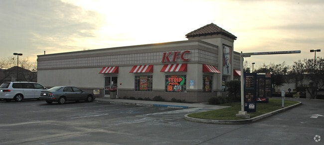

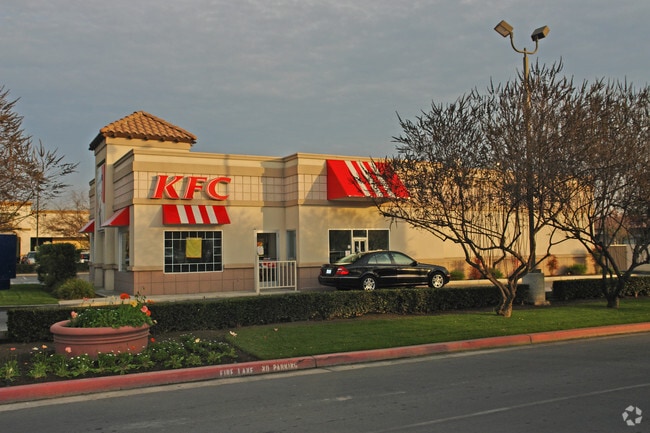

Property Detail
5143 W Walnut Ave
119-650-002-000
PAR 2 PM 4352 B44 P57
Restaurantbuilding
Tulare
CN
California
AE The base floodplain where base flood elevations are provided. AE Zones are now used on new format FIRMs instead of A1-A30 Zones.
0.66 AC
2024
Southwest Visalia
2025
Visalia/Porterville
002004
Visalia, CA
2,711 SF
NEARBY LISTINGS FOR SALE OR LEASE
DEMOGRAPHICS near 5143 W Walnut Ave
1 mile
3 mile
5 mile
2025 Total Population
16,048
76,481
144,058
2030 Population
16,382
78,044
147,574
Pop Growth 2025-2030
+ 2.08%
+ 2.04%
+ 2.44%
Average Age
39
38
36
2025 Total Households
5,727
26,327
47,288
HH Growth 2025-2030
+ 2.18%
+ 2.07%
+ 2.40%
Median Household Inc
$91,970
$91,119
$85,323
Avg Household Size
2.70
2.80
3.00
2025 Avg HH Vehicles
2.00
2.00
2.00
Median Home Value
$368,300
$378,877
$370,596
Median Year Built
1984
1984
1987
Nearby Places
Map Layers
Map Styles
 Street
 Aerial
Layers
 Traffic
 Biking
Places
Listings with unknown addresses are not visible on the map
- Restaurants
- Banks
- Shops
- Fitness
- Groceries
PUBLIC TRANSPORTATION
AIRPORT
Fresno Yosemite International
Drive
Walk
Distance
Fresno Yosemite International
55 min
42.2 mi
Nearby Properties
Address
Land Use
TOTAL SIZE
Lot Size
Zoning
Address
Land Use
TOTAL SIZE
Lot Size
Zoning
393,784 SF
17.79 AC
CR
Address
Land Use
TOTAL SIZE
Lot Size
Zoning
384,146 SF
18.37 AC
IH
Address
Land Use
TOTAL SIZE
Lot Size
Zoning
42,084 SF
9.18 AC
RM2
Address
Land Use
TOTAL SIZE
Lot Size
Zoning
159,023 SF
14.82 AC
CR
Address
Land Use
TOTAL SIZE
Lot Size
Zoning
121,380 SF
24.96 AC
QP
Address
Land Use
TOTAL SIZE
Lot Size
Zoning
148,667 SF
11.35 AC
CR
Address
Land Use
TOTAL SIZE
Lot Size
Zoning
6.96 AC
Address
Land Use
TOTAL SIZE
Lot Size
Zoning
61,587 SF
0.43 AC
PA
Address
Land Use
TOTAL SIZE
Lot Size
Zoning
178,626 SF
11.39 AC
PA
Address
Land Use
TOTAL SIZE
Lot Size
Zoning
19.34 AC
QP
Address
Land Use
TOTAL SIZE
Lot Size
Zoning
134,561 SF
11.55 AC
CR
Address
Land Use
TOTAL SIZE
Lot Size
Zoning
92,298 SF
7.32 AC
CR
Address
Land Use
TOTAL SIZE
Lot Size
Zoning
549,395 SF
29.81 AC
IL
Address
Land Use
TOTAL SIZE
Lot Size
Zoning
33,981 SF
18.12 AC
Address
Land Use
TOTAL SIZE
Lot Size
Zoning
103,000 SF
11.17 AC
CCM
Address
Land Use
TOTAL SIZE
Lot Size
Zoning
78,751 SF
2.67 AC
R-M-2
Address
Land Use
TOTAL SIZE
Lot Size
Zoning
5.85 AC
RM2
Address
Land Use
TOTAL SIZE
Lot Size
Zoning
82,200 SF
6.29 AC
CSO
Address
Land Use
TOTAL SIZE
Lot Size
Zoning
10.13 AC
Address
Land Use
TOTAL SIZE
Lot Size
Zoning
69,120 SF
5.23 AC
CR
Address
Land Use
TOTAL SIZE
Lot Size
Zoning
Address
Land Use
TOTAL SIZE
Lot Size
Zoning
28,557 SF
2.88 AC
CR
Address
Land Use
TOTAL SIZE
Lot Size
Zoning
32,048 SF
2.81 AC
CSO
Address
Land Use
TOTAL SIZE
Lot Size
Zoning
83,011 SF
4.46 AC
QP
Address
Land Use
TOTAL SIZE
Lot Size
Zoning
88,589 SF
7.98 AC
CR
Address
Land Use
TOTAL SIZE
Lot Size
Zoning
36.46 AC
Address
Land Use
TOTAL SIZE
Lot Size
Zoning
41,073 SF
3.30 AC
CR
Address
Land Use
TOTAL SIZE
Lot Size
Zoning
17,933 SF
3.98 AC
CR
Address
Land Use
TOTAL SIZE
Lot Size
Zoning
59,808 SF
34.14 AC
IH
The World's #1 Commercial Real Estate Marketplace
Connect with us
© 2026 CoStar Group
The information above has been obtained from sources believed reliable. While we do not doubt its accuracy we have not verified it and make no guarantee, warranty or representation about it. It is your responsibility to independently confirm its accuracy and completeness. Any projections, opinions, assumptions, or estimates used are for example only and do not represent the current or future performance of the property. The value of this transaction to you depends on tax and other factors which should be evaluated by your tax, financial, and legal advisors. You and your advisors should conduct a careful, independent investigation of the property to determine to your satisfaction the suitability of the property for your needs.