Property Record
5145 N 124Th St, Butler, WI 53007


Save to a Folder
{{folder.Name}}
{{folder.ListingIds.length}} Properties
{{folder.ListingIds.length}} Property
Create a New Folder
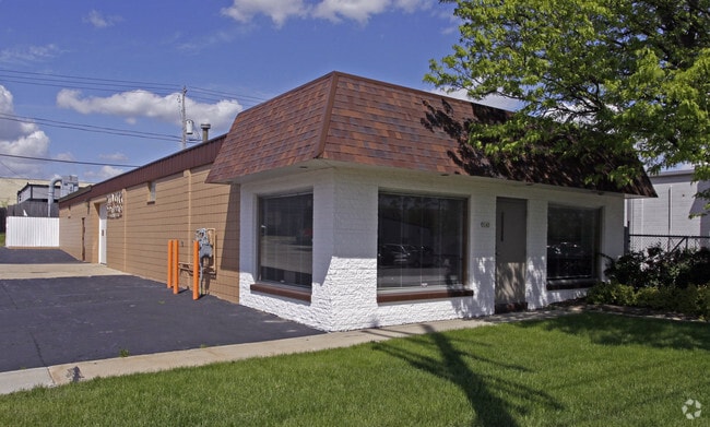
Property Detail
5145 N 124Th St
Milwaukee-Waukesha, WI
LOT 6 BLK 1 & E1/2 ABUTTING VACATED ALLEY NEW BUTLER PT SE1/4 SEC 36 T8N R20E & PT NE1/4 SEC 1 T7N R20E R1856/690 & DOC# 3614961
BV-0144-005
WAUKESHA
Commercialnec
Wisconsin
B and X Area of moderate flood hazard, usually the area between the limits of the 100-year and 500-year floods.
6
0
0.11 AC
2025
NE/Menomonee Falls
200600
Milwaukee/Madison
NEARBY LISTINGS FOR SALE OR LEASE
DEMOGRAPHICS near 5145 N 124Th St
1 mile
3 mile
5 mile
2025 Total Population
4,761
75,055
214,474
2030 Population
4,820
75,693
215,781
Pop Growth 2025-2030
+ 1.24%
+ 0.85%
+ 0.61%
Average Age
38
39
39
2025 Total Households
2,184
29,589
85,605
HH Growth 2025-2030
+ 1.19%
+ 0.87%
+ 0.58%
Median Household Inc
$56,305
$72,858
$73,565
Avg Household Size
2.10
2.50
2.40
2025 Avg HH Vehicles
2.00
2.00
2.00
Median Home Value
$209,896
$266,831
$267,212
Median Year Built
1970
1964
1960
Nearby Places
Map Layers
Map Styles
 Street
 Aerial
Layers
 Traffic
 Biking
Places
Listings with unknown addresses are not visible on the map
- Restaurants
- Banks
- Shops
- Fitness
- Groceries
PUBLIC TRANSPORTATION
AIRPORT
General Mitchell International
Drive
Walk
Distance
General Mitchell International
31 min
19.0 mi
Freight Ports
Port Milwaukee
Drive
Walk
Distance
Port Milwaukee
24 min
15.2 mi
Nearby Properties
Address
Land Use
TOTAL SIZE
Lot Size
Zoning
Address
Land Use
TOTAL SIZE
Lot Size
Zoning
78,185 SF
73.67 AC
M1
Address
Land Use
TOTAL SIZE
Lot Size
Zoning
1.91 AC
Address
Land Use
TOTAL SIZE
Lot Size
Zoning
28,800 SF
3.30 AC
C2
Address
Land Use
TOTAL SIZE
Lot Size
Zoning
18.95 AC
Address
Land Use
TOTAL SIZE
Lot Size
Zoning
56.46 AC
M1
Address
Land Use
TOTAL SIZE
Lot Size
Zoning
369,652 SF
20 AC
Address
Land Use
TOTAL SIZE
Lot Size
Zoning
21.66 AC
M2
Address
Land Use
TOTAL SIZE
Lot Size
Zoning
26.49 AC
Address
Land Use
TOTAL SIZE
Lot Size
Zoning
121,472 SF
8.97 AC
Address
Land Use
TOTAL SIZE
Lot Size
Zoning
864,365 SF
50.22 AC
Address
Land Use
TOTAL SIZE
Lot Size
Zoning
2.45 AC
C2
Address
Land Use
TOTAL SIZE
Lot Size
Zoning
222,355 SF
4.32 AC
Address
Land Use
TOTAL SIZE
Lot Size
Zoning
Address
Land Use
TOTAL SIZE
Lot Size
Zoning
387,379 SF
20.25 AC
Address
Land Use
TOTAL SIZE
Lot Size
Zoning
8.03 AC
RM1
Address
Land Use
TOTAL SIZE
Lot Size
Zoning
139,474 SF
6.43 AC
Address
Land Use
TOTAL SIZE
Lot Size
Zoning
206,529 SF
7.88 AC
PD
Address
Land Use
TOTAL SIZE
Lot Size
Zoning
16.01 AC
Address
Land Use
TOTAL SIZE
Lot Size
Zoning
Address
Land Use
TOTAL SIZE
Lot Size
Zoning
Address
Land Use
TOTAL SIZE
Lot Size
Zoning
12.73 AC
C2
Address
Land Use
TOTAL SIZE
Lot Size
Zoning
28.28 AC
M2
Address
Land Use
TOTAL SIZE
Lot Size
Zoning
326,619 SF
30.69 AC
PD
Address
Land Use
TOTAL SIZE
Lot Size
Zoning
209,138 SF
14.70 AC
Address
Land Use
TOTAL SIZE
Lot Size
Zoning
11.66 AC
C2
Address
Land Use
TOTAL SIZE
Lot Size
Zoning
221,548 SF
11.80 AC
PD
Address
Land Use
TOTAL SIZE
Lot Size
Zoning
160,000 SF
12.48 AC
Address
Land Use
TOTAL SIZE
Lot Size
Zoning
358,699 SF
24.97 AC
Address
Land Use
TOTAL SIZE
Lot Size
Zoning
12.49 AC
TL
Address
Land Use
TOTAL SIZE
Lot Size
Zoning
142,177 SF
2.60 AC
The World's #1 Commercial Real Estate Marketplace
Connect with us
© 2026 CoStar Group
The information above has been obtained from sources believed reliable. While we do not doubt its accuracy we have not verified it and make no guarantee, warranty or representation about it. It is your responsibility to independently confirm its accuracy and completeness. Any projections, opinions, assumptions, or estimates used are for example only and do not represent the current or future performance of the property. The value of this transaction to you depends on tax and other factors which should be evaluated by your tax, financial, and legal advisors. You and your advisors should conduct a careful, independent investigation of the property to determine to your satisfaction the suitability of the property for your needs.