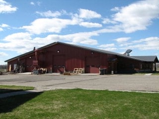
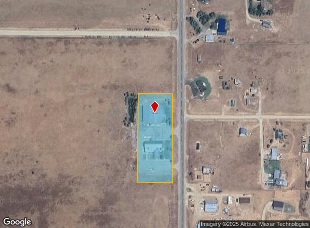
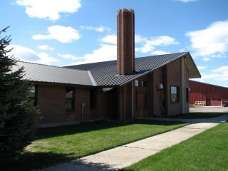
Property Record
5146 N Highway 33, Tetonia, ID 83452
NEARBY LISTINGS FOR SALE OR LEASE
-
-
View all Tetonia listings for sale on LoopNet.com
Property Detail
5146 N Highway 33
Other Market Areas
Clawson
Jackson, WY-ID
TAX #3607 SEC 35 T6N R45E
RP06N45E357199
Teton
Commercialnec
Idaho
2025
3 AC
2025
Idaho South Area
960101
DEMOGRAPHICS near 5146 N Highway 33
1 Mile
3 Mile
5 Mile
2024 Total Population
183
1,218
4,461
2029 Population
220
1,460
5,313
Pop Growth 2024-2029
+ 20.22%
+ 19.87%
+ 19.10%
Average Age
42
42
40
2024 Total Households
73
466
1,724
HH Growth 2024-2029
+ 19.18%
+ 18.67%
+ 17.98%
Median Household Inc
$88,333
$58,640
$82,625
Avg Household Size
2.50
2.50
2.50
2024 Avg HH Vehicles
3.00
3.00
2.00
Median Home Value
$532,258
$398,025
$440,052
Median Year Built
1993
1979
1994
Nearby Places
Map Layers
Map Styles
 Street
 Aerial
- Restaurants
- Banks
- Shops
- Fitness
- Groceries
PUBLIC TRANSPORTATION
AIRPORT
Jackson Hole
DRIVE
WALK
Distance
Jackson Hole
74 min
47.5 mi
Nearby Properties
Address
Land Use
TOTAL SIZE
Lot Size
Zoning
Address
Land Use
TOTAL SIZE
Lot Size
Zoning
5,810 SF
10.04 AC
RN
Address
Land Use
TOTAL SIZE
Lot Size
Zoning
3,854 SF
19.69 AC
RN
Address
Land Use
TOTAL SIZE
Lot Size
Zoning
7,179 SF
18.33 AC
AOI-2.5
Address
Land Use
TOTAL SIZE
Lot Size
Zoning
4,915 SF
4.57 AC
RN
Address
Land Use
TOTAL SIZE
Lot Size
Zoning
3,715 SF
4.88 AC
RN
Address
Land Use
TOTAL SIZE
Lot Size
Zoning
4,951 SF
12.38 AC
RN
Address
Land Use
TOTAL SIZE
Lot Size
Zoning
4,788 SF
13.92 AC
RA-35
Address
Land Use
TOTAL SIZE
Lot Size
Zoning
3,813 SF
9.54 AC
RN
Address
Land Use
TOTAL SIZE
Lot Size
Zoning
3,774 SF
2.51 AC
RN
Address
Land Use
TOTAL SIZE
Lot Size
Zoning
3,770 SF
7.50 AC
FH-20
Address
Land Use
TOTAL SIZE
Lot Size
Zoning
3,842 SF
4.41 AC
RN
Address
Land Use
TOTAL SIZE
Lot Size
Zoning
6,166 SF
2.50 AC
RA-35
Address
Land Use
TOTAL SIZE
Lot Size
Zoning
4,720 SF
2.57 AC
RN
Address
Land Use
TOTAL SIZE
Lot Size
Zoning
3,045 SF
1.56 AC
RN
Address
Land Use
TOTAL SIZE
Lot Size
Zoning
3,944 SF
2.39 AC
RN
Address
Land Use
TOTAL SIZE
Lot Size
Zoning
6,120 SF
5 AC
LA-35
Address
Land Use
TOTAL SIZE
Lot Size
Zoning
2,930 SF
3.68 AC
RA-35
Address
Land Use
TOTAL SIZE
Lot Size
Zoning
2,762 SF
3.25 AC
RN
Address
Land Use
TOTAL SIZE
Lot Size
Zoning
2,000 SF
12.49 AC
RN
Address
Land Use
TOTAL SIZE
Lot Size
Zoning
2.49 AC
AOI-2.5
Address
Land Use
TOTAL SIZE
Lot Size
Zoning
3,484 SF
23.61 AC
AOI-2.5
Address
Land Use
TOTAL SIZE
Lot Size
Zoning
3,532 SF
2.46 AC
RN
Address
Land Use
TOTAL SIZE
Lot Size
Zoning
3,168 SF
2.21 AC
FH-20
Address
Land Use
TOTAL SIZE
Lot Size
Zoning
2,816 SF
2.50 AC
RN
Address
Land Use
TOTAL SIZE
Lot Size
Zoning
2,819 SF
1.95 AC
RN
Address
Land Use
TOTAL SIZE
Lot Size
Zoning
1,004 SF
51.91 AC
RN
Address
Land Use
TOTAL SIZE
Lot Size
Zoning
1,204 SF
25.13 AC
AOI-2.5
Address
Land Use
TOTAL SIZE
Lot Size
Zoning
3,509 SF
2.49 AC
RA-35
Address
Land Use
TOTAL SIZE
Lot Size
Zoning
2,079 SF
5 AC
RN
Address
Land Use
TOTAL SIZE
Lot Size
Zoning
4,240 SF
6.26 AC
AOI-2.5
The World's #1 Commercial Real Estate Marketplace
Connect with us
© 2025 CoStar Group
The information above has been obtained from sources believed reliable. While we do not doubt its accuracy we have not verified it and make no guarantee, warranty or representation about it. It is your responsibility to independently confirm its accuracy and completeness. Any projections, opinions, assumptions, or estimates used are for example only and do not represent the current or future performance of the property. The value of this transaction to you depends on tax and other factors which should be evaluated by your tax, financial, and legal advisors. You and your advisors should conduct a careful, independent investigation of the property to determine to your satisfaction the suitability of the property for your needs.