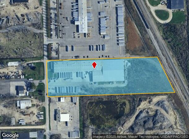
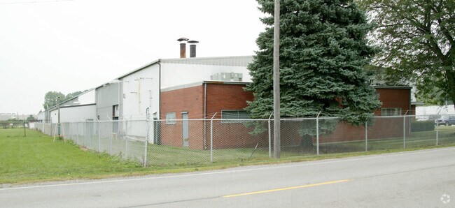
Property Record
5148 Stickney Ave, Toledo, OH 43612

NEARBY LISTINGS FOR SALE OR LEASE
Property Detail
5148 Stickney Ave
22-75984
8 9 7 SW 1/4 N 8.92 AC SW 1/4 W OF RR
Lightindustrial
Lucas
X
Ohio
39095C0084G
106
0
8.92 AC
2025
North Toledo
005602
Toledo
98,033 SF
Toledo, OH
DEMOGRAPHICS near 5148 Stickney Ave
1 Mile
3 Mile
5 Mile
2024 Total Population
1,142
61,306
162,390
2029 Population
1,131
60,945
162,225
Pop Growth 2024-2029
(0.96%)
(0.59%)
(0.10%)
Average Age
38
38
39
2024 Total Households
496
25,096
69,030
HH Growth 2024-2029
(1.01%)
(0.71%)
(0.16%)
Median Household Inc
$46,458
$42,417
$42,790
Avg Household Size
2.30
2.30
2.20
2024 Avg HH Vehicles
2.00
2.00
2.00
Median Home Value
$66,468
$81,610
$97,838
Median Year Built
1962
1952
1953
Nearby Places
Map Layers
Map Styles
 Street
 Aerial
- Restaurants
- Banks
- Shops
- Fitness
- Groceries
PUBLIC TRANSPORTATION
COMMUTER RAIL
DRIVE
WALK
Distance
13 min
6.0 mi
AIRPORT
Eugene F Kranz Toledo Express
DRIVE
WALK
Distance
Eugene F Kranz Toledo Express
42 min
25.5 mi
Detroit Metro Wayne County
DRIVE
WALK
Distance
Detroit Metro Wayne County
55 min
42.6 mi
Freight Ports
DRIVE
WALK
Distance
18 min
8.3 mi
Nearby Properties
Address
Land Use
TOTAL SIZE
Lot Size
Zoning
Address
Land Use
TOTAL SIZE
Lot Size
Zoning
569,999 SF
45.25 AC
10-MX
Address
Land Use
TOTAL SIZE
Lot Size
Zoning
286,525 SF
105.33 AC
10-RS6
Address
Land Use
TOTAL SIZE
Lot Size
Zoning
169.42 AC
10-IG
Address
Land Use
TOTAL SIZE
Lot Size
Zoning
1,972,579 SF
76.32 AC
10-IG
Address
Land Use
TOTAL SIZE
Lot Size
Zoning
693,900 SF
76.32 AC
10-IG
Address
Land Use
TOTAL SIZE
Lot Size
Zoning
171,946 SF
0.17 AC
10-IC
Address
Land Use
TOTAL SIZE
Lot Size
Zoning
Address
Land Use
TOTAL SIZE
Lot Size
Zoning
76.32 AC
10-IG
Address
Land Use
TOTAL SIZE
Lot Size
Zoning
169.42 AC
10-IG
Address
Land Use
TOTAL SIZE
Lot Size
Zoning
33.48 AC
10-IG
Address
Land Use
TOTAL SIZE
Lot Size
Zoning
172,044 SF
12.78 AC
10-MX
Address
Land Use
TOTAL SIZE
Lot Size
Zoning
163,962 SF
10.13 AC
Address
Land Use
TOTAL SIZE
Lot Size
Zoning
28.51 AC
10-IG
Address
Land Use
TOTAL SIZE
Lot Size
Zoning
450,000 SF
37.30 AC
Address
Land Use
TOTAL SIZE
Lot Size
Zoning
230,400 SF
18 AC
10-CR
Address
Land Use
TOTAL SIZE
Lot Size
Zoning
34.13 AC
10-IG
Address
Land Use
TOTAL SIZE
Lot Size
Zoning
90,113 SF
8.12 AC
21-PO
Address
Land Use
TOTAL SIZE
Lot Size
Zoning
Address
Land Use
TOTAL SIZE
Lot Size
Zoning
20.67 AC
10-MX
Address
Land Use
TOTAL SIZE
Lot Size
Zoning
84,527 SF
7.79 AC
10-RS6
Address
Land Use
TOTAL SIZE
Lot Size
Zoning
47,600 SF
5.04 AC
Address
Land Use
TOTAL SIZE
Lot Size
Zoning
175,978 SF
10.02 AC
10-IL
Address
Land Use
TOTAL SIZE
Lot Size
Zoning
282,124 SF
9.71 AC
10-IC
Address
Land Use
TOTAL SIZE
Lot Size
Zoning
71,918 SF
7 AC
10-RS6
Address
Land Use
TOTAL SIZE
Lot Size
Zoning
328,898 SF
13.67 AC
10-IG
Address
Land Use
TOTAL SIZE
Lot Size
Zoning
302,338 SF
13.97 AC
Address
Land Use
TOTAL SIZE
Lot Size
Zoning
90,507 SF
9 AC
10-CRSO
Address
Land Use
TOTAL SIZE
Lot Size
Zoning
106.75 AC
AC = AG
Address
Land Use
TOTAL SIZE
Lot Size
Zoning
92,888 SF
20.24 AC
10-IL
Address
Land Use
TOTAL SIZE
Lot Size
Zoning
159,798 SF
8.32 AC
10-IL
The World's #1 Commercial Real Estate Marketplace
Connect with us
© 2026 CoStar Group
The information above has been obtained from sources believed reliable. While we do not doubt its accuracy we have not verified it and make no guarantee, warranty or representation about it. It is your responsibility to independently confirm its accuracy and completeness. Any projections, opinions, assumptions, or estimates used are for example only and do not represent the current or future performance of the property. The value of this transaction to you depends on tax and other factors which should be evaluated by your tax, financial, and legal advisors. You and your advisors should conduct a careful, independent investigation of the property to determine to your satisfaction the suitability of the property for your needs.