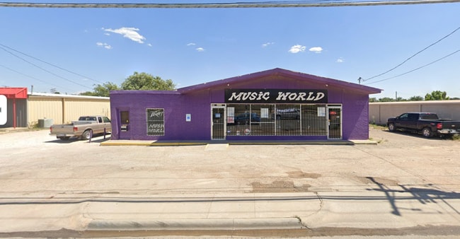
Property Record
515 W 42Nd St, Odessa, TX 79764

Property Detail
515 W 42Nd St
42220-00070-00000
T-2-S BLK 42 SEC 16 (CARD #6M)
Commercialnec
Ector
EB2
Texas
A Areas with a 1% annual chance of flooding and a 26% chance of flooding over the life of a 30-year mortgage.
0.22 AC
2025
Midland & Odessa
2025
Other Market Areas
000700
Odessa, TX
1,560 SF
NEARBY LISTINGS FOR SALE OR LEASE
DEMOGRAPHICS near 515 W 42Nd St
1 mile
3 mile
5 mile
2025 Total Population
9,546
70,103
121,054
2030 Population
10,185
74,511
129,156
Pop Growth 2025-2030
+ 6.69%
+ 6.29%
+ 6.69%
Average Age
34
35
35
2025 Total Households
3,518
25,367
43,347
HH Growth 2025-2030
+ 7.96%
+ 7.49%
+ 7.86%
Median Household Inc
$60,142
$64,504
$65,249
Avg Household Size
2.60
2.70
2.70
2025 Avg HH Vehicles
2.00
2.00
2.00
Median Home Value
$114,911
$172,257
$186,582
Median Year Built
1975
1969
1976
Nearby Places
Map Layers
Map Styles
 Street
 Aerial
Layers
 Traffic
 Biking
Places
Listings with unknown addresses are not visible on the map
- Restaurants
- Banks
- Shops
- Fitness
- Groceries
PUBLIC TRANSPORTATION
AIRPORT
Midland International Air And Space Port
Drive
Walk
Distance
Midland International Air And Space Port
20 min
14.3 mi
Freight Ports
Port of Corpus Christi
Drive
Walk
Distance
Port of Corpus Christi
506 min
489.2 mi
SALE & LEASE HISTORY
LISTING DATE
SALE/LEASE

Oct 03, 2025
For Lease
Oct 03, 2025
For Sale
Jul 11, 2023
For Sale
Feb 06, 2025
For Sale
Nearby Properties
Address
Land Use
TOTAL SIZE
Lot Size
Zoning
Address
Land Use
TOTAL SIZE
Lot Size
Zoning
170,241 SF
16.56 AC
EB6
Address
Land Use
TOTAL SIZE
Lot Size
Zoning
Address
Land Use
TOTAL SIZE
Lot Size
Zoning
Address
Land Use
TOTAL SIZE
Lot Size
Zoning
22,304 SF
67.42 AC
EB4
Address
Land Use
TOTAL SIZE
Lot Size
Zoning
Address
Land Use
TOTAL SIZE
Lot Size
Zoning
54,990 SF
46.21 AC
ED5
Address
Land Use
TOTAL SIZE
Lot Size
Zoning
Address
Land Use
TOTAL SIZE
Lot Size
Zoning
Address
Land Use
TOTAL SIZE
Lot Size
Zoning
Address
Land Use
TOTAL SIZE
Lot Size
Zoning
159,239 SF
6.64 AC
EE1
Address
Land Use
TOTAL SIZE
Lot Size
Zoning
57,566 SF
Address
Land Use
TOTAL SIZE
Lot Size
Zoning
30,600 SF
4.51 AC
EB6
Address
Land Use
TOTAL SIZE
Lot Size
Zoning
2,268 SF
15.91 AC
EB2
Address
Land Use
TOTAL SIZE
Lot Size
Zoning
Address
Land Use
TOTAL SIZE
Lot Size
Zoning
136,794 SF
631.22 AC
EC3
Address
Land Use
TOTAL SIZE
Lot Size
Zoning
192,022 SF
8.83 AC
ED3
Address
Land Use
TOTAL SIZE
Lot Size
Zoning
80,722 SF
20.09 AC
ED3
Address
Land Use
TOTAL SIZE
Lot Size
Zoning
22,470 SF
2.07 AC
EB6
Address
Land Use
TOTAL SIZE
Lot Size
Zoning
197,580 SF
8.77 AC
ED3
Address
Land Use
TOTAL SIZE
Lot Size
Zoning
Address
Land Use
TOTAL SIZE
Lot Size
Zoning
Address
Land Use
TOTAL SIZE
Lot Size
Zoning
111,278 SF
28.53 AC
EB6
Address
Land Use
TOTAL SIZE
Lot Size
Zoning
155,744 SF
49.20 AC
EA7
Address
Land Use
TOTAL SIZE
Lot Size
Zoning
99,244 SF
4.66 AC
EE1
Address
Land Use
TOTAL SIZE
Lot Size
Zoning
214,832 SF
10.42 AC
EB5
Address
Land Use
TOTAL SIZE
Lot Size
Zoning
7,236 SF
10.80 AC
ED3
Address
Land Use
TOTAL SIZE
Lot Size
Zoning
Address
Land Use
TOTAL SIZE
Lot Size
Zoning
2,978 SF
56 AC
ED2
Address
Land Use
TOTAL SIZE
Lot Size
Zoning
109,381 SF
16.74 AC
EB3
Address
Land Use
TOTAL SIZE
Lot Size
Zoning
133,454 SF
25.41 AC
EE2
The World's #1 Commercial Real Estate Marketplace
Connect with us
© 2026 CoStar Group
The information above has been obtained from sources believed reliable. While we do not doubt its accuracy we have not verified it and make no guarantee, warranty or representation about it. It is your responsibility to independently confirm its accuracy and completeness. Any projections, opinions, assumptions, or estimates used are for example only and do not represent the current or future performance of the property. The value of this transaction to you depends on tax and other factors which should be evaluated by your tax, financial, and legal advisors. You and your advisors should conduct a careful, independent investigation of the property to determine to your satisfaction the suitability of the property for your needs.