Property Record
515 Division St N, Rice, MN 56367
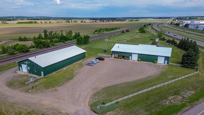


This Property Is For Sale
Property Detail
515 Division St N
15.00058.00
SECT-29 TWP-038 RANGE-031 4.78 AC PART OF E1/2 NW1/4 LYING WLY OF ELY 65 FT & NELY OF RR R/W & SLY OF HWY 10 R/W LESS PART
Utilities
Benton
B and X Area of moderate flood hazard, usually the area between the limits of the 100-year and 500-year floods.
Minnesota
2025
4.78 AC
2025
Benton County
020203
Minneapolis/St Paul
14,400 SF
St. Cloud, MN
NEARBY LISTINGS FOR SALE OR LEASE
-
-
View all Rice listings for sale on LoopNet.com
DEMOGRAPHICS near 515 Division St N
1 mile
3 mile
5 mile
2025 Total Population
1,416
3,713
7,472
2030 Population
1,454
3,800
7,638
Pop Growth 2025-2030
+ 2.68%
+ 2.34%
+ 2.22%
Average Age
33
36
39
2025 Total Households
499
1,345
2,747
HH Growth 2025-2030
+ 2.81%
+ 2.45%
+ 2.29%
Median Household Inc
$100,741
$99,999
$101,087
Avg Household Size
2.80
2.80
2.70
2025 Avg HH Vehicles
2.00
3.00
3.00
Median Home Value
$251,268
$262,773
$288,442
Median Year Built
2004
1998
1991
Nearby Places
Map Layers
Map Styles
 Street
 Aerial
Transit
 Traffic
 Biking
Places
Listings with unknown addresses are not visible on the map
- Restaurants
- Banks
- Shops
- Fitness
- Groceries
Nearby Properties
Address
Land Use
TOTAL SIZE
Lot Size
Zoning
Address
Land Use
TOTAL SIZE
Lot Size
Zoning
83,422 SF
20.36 AC
Address
Land Use
TOTAL SIZE
Lot Size
Zoning
76,320 SF
10.23 AC
Address
Land Use
TOTAL SIZE
Lot Size
Zoning
36,500 SF
56 AC
Address
Land Use
TOTAL SIZE
Lot Size
Zoning
61,655 SF
9.60 AC
Address
Land Use
TOTAL SIZE
Lot Size
Zoning
18,696 SF
38.81 AC
Address
Land Use
TOTAL SIZE
Lot Size
Zoning
63,000 SF
20.09 AC
Address
Land Use
TOTAL SIZE
Lot Size
Zoning
6.16 AC
Address
Land Use
TOTAL SIZE
Lot Size
Zoning
1,312 SF
83.94 AC
Address
Land Use
TOTAL SIZE
Lot Size
Zoning
4,590 SF
29.86 AC
Address
Land Use
TOTAL SIZE
Lot Size
Zoning
13,600 SF
2.50 AC
Address
Land Use
TOTAL SIZE
Lot Size
Zoning
53.43 AC
Address
Land Use
TOTAL SIZE
Lot Size
Zoning
327 AC
Address
Land Use
TOTAL SIZE
Lot Size
Zoning
12,000 SF
4.19 AC
Address
Land Use
TOTAL SIZE
Lot Size
Zoning
1,536 SF
198.08 AC
Address
Land Use
TOTAL SIZE
Lot Size
Zoning
4.60 AC
Address
Land Use
TOTAL SIZE
Lot Size
Zoning
23,584 SF
7.28 AC
Address
Land Use
TOTAL SIZE
Lot Size
Zoning
3,407 SF
34 AC
Address
Land Use
TOTAL SIZE
Lot Size
Zoning
Address
Land Use
TOTAL SIZE
Lot Size
Zoning
67.87 AC
RPMKT
Address
Land Use
TOTAL SIZE
Lot Size
Zoning
5,384 SF
1.85 AC
Address
Land Use
TOTAL SIZE
Lot Size
Zoning
9,348 SF
5.05 AC
Address
Land Use
TOTAL SIZE
Lot Size
Zoning
6,129 SF
6.97 AC
Address
Land Use
TOTAL SIZE
Lot Size
Zoning
1,456 SF
40.65 AC
Address
Land Use
TOTAL SIZE
Lot Size
Zoning
11,997 SF
8.57 AC
Address
Land Use
TOTAL SIZE
Lot Size
Zoning
122.55 AC
Address
Land Use
TOTAL SIZE
Lot Size
Zoning
15,000 SF
1.97 AC
Address
Land Use
TOTAL SIZE
Lot Size
Zoning
6,849 SF
5.46 AC
The World's #1 Commercial Real Estate Marketplace
Connect with us
© 2026 CoStar Group
The information above has been obtained from sources believed reliable. While we do not doubt its accuracy we have not verified it and make no guarantee, warranty or representation about it. It is your responsibility to independently confirm its accuracy and completeness. Any projections, opinions, assumptions, or estimates used are for example only and do not represent the current or future performance of the property. The value of this transaction to you depends on tax and other factors which should be evaluated by your tax, financial, and legal advisors. You and your advisors should conduct a careful, independent investigation of the property to determine to your satisfaction the suitability of the property for your needs.