Property Record
445 E Carefree Hwy, Phoenix, AZ 85085

NEARBY LISTINGS FOR SALE OR LEASE
-
-
View all Phoenix listings for sale on LoopNet.com
Property Detail
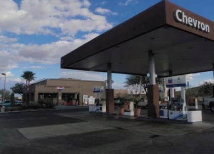
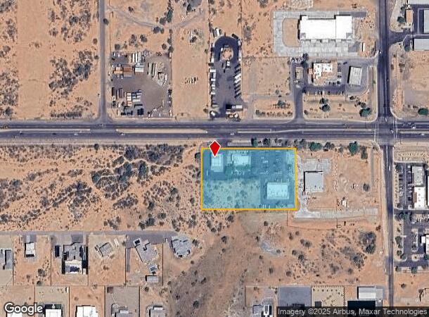
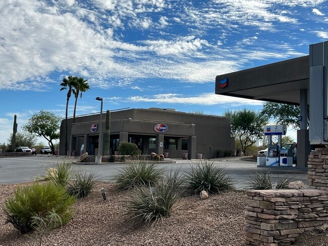
445 E Carefree Hwy
211-24-033A
POR N 355F OF E 860F N2 NE4 SEC 8 DAF COM NE COR NE4 TH W 424F TH S 75F POB TH S 280F TH W 436F TH N 280F TH E 436F TO POB P/F 10-574965
Storesoffices
Maricopa
X
Arizona
04013C0865L
2.80 AC
2025
Anthem
2025
Phoenix
612000
Phoenix-Mesa-Scottsdale, AZ
9,230 SF
DEMOGRAPHICS near 445 E Carefree Hwy
1 Mile
3 Mile
5 Mile
2024 Total Population
1,691
18,013
57,003
2029 Population
1,839
19,548
62,041
Pop Growth 2024-2029
+ 8.75%
+ 8.52%
+ 8.84%
Average Age
46
41
41
2024 Total Households
633
6,723
21,081
HH Growth 2024-2029
+ 8.85%
+ 8.51%
+ 8.86%
Median Household Inc
$126,731
$128,142
$118,867
Avg Household Size
2.70
2.60
2.70
2024 Avg HH Vehicles
3.00
2.00
2.00
Median Home Value
$525,862
$489,668
$479,959
Median Year Built
2000
2005
2005
Nearby Places
Map Layers
Map Styles
 Street
 Aerial
- Restaurants
- Banks
- Shops
- Fitness
- Groceries
PUBLIC TRANSPORTATION
AIRPORT
Phoenix Sky Harbor International
DRIVE
WALK
Distance
Phoenix Sky Harbor International
50 min
35.8 mi
Freight Ports
Port of San Diego
DRIVE
WALK
Distance
Port of San Diego
421 min
374.3 mi
SALE & LEASE HISTORY
LISTING DATE
SALE/LEASE

Dec 18, 2023
For Sale
Nearby Properties
Address
Land Use
TOTAL SIZE
Lot Size
Zoning
Address
Land Use
TOTAL SIZE
Lot Size
Zoning
285,327 SF
13.67 AC
C-C
Address
Land Use
TOTAL SIZE
Lot Size
Zoning
113,123 SF
62.17 AC
R-43
Address
Land Use
TOTAL SIZE
Lot Size
Zoning
82,674 SF
14.61 AC
PAD
Address
Land Use
TOTAL SIZE
Lot Size
Zoning
227,103 SF
13.75 AC
M-H
Address
Land Use
TOTAL SIZE
Lot Size
Zoning
220,053 SF
15.34 AC
R-3A
Address
Land Use
TOTAL SIZE
Lot Size
Zoning
67,261 SF
22.86 AC
RU43
Address
Land Use
TOTAL SIZE
Lot Size
Zoning
254 SF
527.88 AC
R-35
Address
Land Use
TOTAL SIZE
Lot Size
Zoning
69,514 SF
5.82 AC
C-C
Address
Land Use
TOTAL SIZE
Lot Size
Zoning
69,996 SF
9.72 AC
PCD
Address
Land Use
TOTAL SIZE
Lot Size
Zoning
59,325 SF
6.21 AC
C-C
Address
Land Use
TOTAL SIZE
Lot Size
Zoning
160.38 AC
R-43AG
Address
Land Use
TOTAL SIZE
Lot Size
Zoning
132,593 SF
6.69 AC
Address
Land Use
TOTAL SIZE
Lot Size
Zoning
315.05 AC
R-43
Address
Land Use
TOTAL SIZE
Lot Size
Zoning
38,585 SF
6.84 AC
RU43
Address
Land Use
TOTAL SIZE
Lot Size
Zoning
22,818 SF
4.47 AC
C-C
Address
Land Use
TOTAL SIZE
Lot Size
Zoning
248 SF
343.16 AC
R-43AG
Address
Land Use
TOTAL SIZE
Lot Size
Zoning
14,590 SF
1.78 AC
C-C
Address
Land Use
TOTAL SIZE
Lot Size
Zoning
20,340 SF
2.83 AC
C-C
Address
Land Use
TOTAL SIZE
Lot Size
Zoning
6,781 SF
2.26 AC
C-C
Address
Land Use
TOTAL SIZE
Lot Size
Zoning
3.72 AC
Address
Land Use
TOTAL SIZE
Lot Size
Zoning
5,022 SF
1.52 AC
C-C
Address
Land Use
TOTAL SIZE
Lot Size
Zoning
6,744 SF
4.51 AC
C-C
Address
Land Use
TOTAL SIZE
Lot Size
Zoning
11,965 SF
1.38 AC
C-C
Address
Land Use
TOTAL SIZE
Lot Size
Zoning
7,434 SF
1.02 AC
C-C
Address
Land Use
TOTAL SIZE
Lot Size
Zoning
5,421 SF
1.60 AC
C-C
Address
Land Use
TOTAL SIZE
Lot Size
Zoning
6,679 SF
1.27 AC
C-C
Address
Land Use
TOTAL SIZE
Lot Size
Zoning
9,678 SF
1.15 AC
C-C
The World's #1 Commercial Real Estate Marketplace
Connect with us
© 2025 CoStar Group
The information above has been obtained from sources believed reliable. While we do not doubt its accuracy we have not verified it and make no guarantee, warranty or representation about it. It is your responsibility to independently confirm its accuracy and completeness. Any projections, opinions, assumptions, or estimates used are for example only and do not represent the current or future performance of the property. The value of this transaction to you depends on tax and other factors which should be evaluated by your tax, financial, and legal advisors. You and your advisors should conduct a careful, independent investigation of the property to determine to your satisfaction the suitability of the property for your needs.