Property Record
515 E Wilson Blvd, Hagerstown, MD 21740
NEARBY LISTINGS FOR SALE OR LEASE
Property Detail
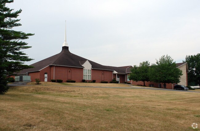
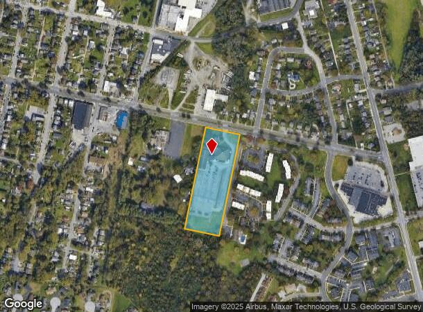
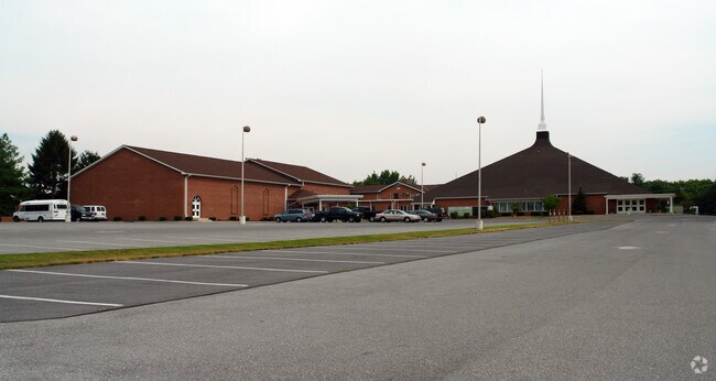
515 E Wilson Blvd
17-022008
First Addition To Hagerstown
Publicschool
6.2 ACRES 515 E WILSON BLVD CHURCH
X
Washington
24043C0305D
Maryland
0
6.20 AC
2025
Washington County
000602
Washington, DC
28,395 SF
Hagerstown-Martinsburg, MD-WV
DEMOGRAPHICS near 515 E Wilson Blvd
1 mile
3 mile
5 mile
2024 Total Population
7,304
63,724
93,646
2029 Population
7,402
64,694
95,006
Pop Growth 2024-2029
+ 1.34%
+ 1.52%
+ 1.45%
Average Age
42
40
40
2024 Total Households
3,164
26,051
37,357
HH Growth 2024-2029
+ 1.30%
+ 1.53%
+ 1.50%
Median Household Inc
$46,807
$49,332
$58,204
Avg Household Size
2.20
2.30
2.40
2024 Avg HH Vehicles
1.00
2.00
2.00
Median Home Value
$159,115
$187,396
$218,864
Median Year Built
1961
1965
1971
Nearby Places
Map Layers
Map Styles
 Street
 Aerial
Transit
 Traffic
 Biking
Places
Listings with unknown addresses are not visible on the map
- Restaurants
- Banks
- Shops
- Fitness
- Groceries
PUBLIC TRANSPORTATION
AIRPORT
Hagerstown Regional/Richard A Henson Field
Drive
Walk
Distance
Hagerstown Regional/Richard A Henson Field
14 min
6.9 mi
Nearby Properties
Address
Land Use
TOTAL SIZE
Lot Size
Zoning
Address
Land Use
TOTAL SIZE
Lot Size
Zoning
502,262 SF
36.64 AC
ORI
Address
Land Use
TOTAL SIZE
Lot Size
Zoning
1,236,085 SF
134.31 AC
IMU
Address
Land Use
TOTAL SIZE
Lot Size
Zoning
1,234,240 SF
134.80 AC
HI
Address
Land Use
TOTAL SIZE
Lot Size
Zoning
1,247,111 SF
74.55 AC
IMU
Address
Land Use
TOTAL SIZE
Lot Size
Zoning
737,000 SF
59.57 AC
PB
Address
Land Use
TOTAL SIZE
Lot Size
Zoning
1,004,194 SF
65.22 AC
IG
Address
Land Use
TOTAL SIZE
Lot Size
Zoning
103,131 SF
53.74 AC
RMOD
Address
Land Use
TOTAL SIZE
Lot Size
Zoning
200,815 SF
9.14 AC
ORI
Address
Land Use
TOTAL SIZE
Lot Size
Zoning
277,977 SF
68.60 AC
IG
Address
Land Use
TOTAL SIZE
Lot Size
Zoning
12,580 SF
1.73 AC
CCMU
Address
Land Use
TOTAL SIZE
Lot Size
Zoning
151,660 SF
56.24 AC
RMOD
Address
Land Use
TOTAL SIZE
Lot Size
Zoning
167,084 SF
64.62 AC
RMOD
Address
Land Use
TOTAL SIZE
Lot Size
Zoning
113,466 SF
10.62 AC
IG
Address
Land Use
TOTAL SIZE
Lot Size
Zoning
91,026 SF
20.28 AC
A
Address
Land Use
TOTAL SIZE
Lot Size
Zoning
622,245 SF
52.90 AC
U
Address
Land Use
TOTAL SIZE
Lot Size
Zoning
77,934 SF
12.79 AC
RMED
Address
Land Use
TOTAL SIZE
Lot Size
Zoning
267,424 SF
21.44 AC
IMU
Address
Land Use
TOTAL SIZE
Lot Size
Zoning
82,403 SF
1.32 AC
CCMU
Address
Land Use
TOTAL SIZE
Lot Size
Zoning
127,315 SF
26.65 AC
RMOD
Address
Land Use
TOTAL SIZE
Lot Size
Zoning
290,600 SF
51.35 AC
IMU
Address
Land Use
TOTAL SIZE
Lot Size
Zoning
52,259 SF
60.86 AC
HI
Address
Land Use
TOTAL SIZE
Lot Size
Zoning
7,427 SF
79.25 AC
RS
Address
Land Use
TOTAL SIZE
Lot Size
Zoning
94,185 SF
9.25 AC
RMED
Address
Land Use
TOTAL SIZE
Lot Size
Zoning
88,116 SF
18.44 AC
RMOD
Address
Land Use
TOTAL SIZE
Lot Size
Zoning
218,568 SF
51.64 AC
U
Address
Land Use
TOTAL SIZE
Lot Size
Zoning
3,984 SF
18.32 AC
CR
Address
Land Use
TOTAL SIZE
Lot Size
Zoning
67,434 SF
4.30 AC
RS
Address
Land Use
TOTAL SIZE
Lot Size
Zoning
80,816 SF
19.68 AC
ORI
Address
Land Use
TOTAL SIZE
Lot Size
Zoning
5,000 SF
22.41 AC
IG
Address
Land Use
TOTAL SIZE
Lot Size
Zoning
123,120 SF
28.54 AC
ORT
The World's #1 Commercial Real Estate Marketplace
Connect with us
© 2026 CoStar Group
The information above has been obtained from sources believed reliable. While we do not doubt its accuracy we have not verified it and make no guarantee, warranty or representation about it. It is your responsibility to independently confirm its accuracy and completeness. Any projections, opinions, assumptions, or estimates used are for example only and do not represent the current or future performance of the property. The value of this transaction to you depends on tax and other factors which should be evaluated by your tax, financial, and legal advisors. You and your advisors should conduct a careful, independent investigation of the property to determine to your satisfaction the suitability of the property for your needs.