Property Record
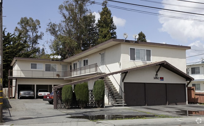
515 Harris Rd, Hayward, CA 94544


NEARBY LISTINGS FOR SALE OR LEASE
Property Detail
515 Harris Rd
453-0060-027-02
Meek Orchard
Multifamilydwelling
PORTION BLK P
X
Alameda
06001C0289G
California
2024
0.20 AC
2025
Harder-Tennyson
437702
East Bay/Oakland
4,725 SF
Oakland-Fremont-Berkeley, CA
DEMOGRAPHICS near 515 Harris Rd
1 mile
3 mile
5 mile
2024 Total Population
39,489
165,241
350,784
2029 Population
38,178
160,062
339,057
Pop Growth 2024-2029
(3.32%)
(3.13%)
(3.34%)
Average Age
39
40
40
2024 Total Households
11,111
50,321
109,705
HH Growth 2024-2029
(3.53%)
(3.28%)
(3.54%)
Median Household Inc
$90,771
$101,164
$107,277
Avg Household Size
3.40
3.10
3.10
2024 Avg HH Vehicles
2.00
2.00
2.00
Median Home Value
$667,001
$747,584
$813,734
Median Year Built
1970
1972
1973
Nearby Places
Map Layers
Map Styles
 Street
 Aerial
Transit
 Traffic
 Biking
Places
Listings with unknown addresses are not visible on the map
- Restaurants
- Banks
- Shops
- Fitness
- Groceries
PUBLIC TRANSPORTATION
COMMUTER RAIL
Drive
Walk
Distance
9 min
4.5 mi
Drive
Walk
Distance
9 min
4.5 mi
AIRPORT
Metro Oakland International
Drive
Walk
Distance
Metro Oakland International
19 min
12.6 mi
San Francisco International
Drive
Walk
Distance
San Francisco International
31 min
23.2 mi
Norman Y Mineta San Jose International
Drive
Walk
Distance
Norman Y Mineta San Jose International
33 min
25.6 mi
Freight Ports
Port of Oakland
Drive
Walk
Distance
Port of Oakland
23 min
17.2 mi
Nearby Properties
Address
Land Use
TOTAL SIZE
Lot Size
Zoning
Address
Land Use
TOTAL SIZE
Lot Size
Zoning
710,091 SF
50.34 AC
Address
Land Use
TOTAL SIZE
Lot Size
Zoning
367,398 SF
21.94 AC
Address
Land Use
TOTAL SIZE
Lot Size
Zoning
6.57 AC
Address
Land Use
TOTAL SIZE
Lot Size
Zoning
240,556 SF
11.63 AC
Address
Land Use
TOTAL SIZE
Lot Size
Zoning
312,244 SF
31.84 AC
Address
Land Use
TOTAL SIZE
Lot Size
Zoning
200,451 SF
11.22 AC
Address
Land Use
TOTAL SIZE
Lot Size
Zoning
236,976 SF
18.36 AC
Address
Land Use
TOTAL SIZE
Lot Size
Zoning
173,948 SF
6.10 AC
Address
Land Use
TOTAL SIZE
Lot Size
Zoning
10.64 AC
Address
Land Use
TOTAL SIZE
Lot Size
Zoning
333,302 SF
13.20 AC
Address
Land Use
TOTAL SIZE
Lot Size
Zoning
175,325 SF
2.91 AC
Address
Land Use
TOTAL SIZE
Lot Size
Zoning
470,929 SF
31.62 AC
Address
Land Use
TOTAL SIZE
Lot Size
Zoning
1.50 AC
Address
Land Use
TOTAL SIZE
Lot Size
Zoning
258,470 SF
11.64 AC
Address
Land Use
TOTAL SIZE
Lot Size
Zoning
Address
Land Use
TOTAL SIZE
Lot Size
Zoning
58,991 SF
9.56 AC
Address
Land Use
TOTAL SIZE
Lot Size
Zoning
150,856 SF
5.99 AC
Address
Land Use
TOTAL SIZE
Lot Size
Zoning
187,926 SF
1.19 AC
Address
Land Use
TOTAL SIZE
Lot Size
Zoning
300,507 SF
15.52 AC
Address
Land Use
TOTAL SIZE
Lot Size
Zoning
160,987 SF
7.20 AC
Address
Land Use
TOTAL SIZE
Lot Size
Zoning
89,145 SF
5.12 AC
Address
Land Use
TOTAL SIZE
Lot Size
Zoning
8,804 SF
52.60 AC
Address
Land Use
TOTAL SIZE
Lot Size
Zoning
169,371 SF
4.63 AC
Address
Land Use
TOTAL SIZE
Lot Size
Zoning
147,489 SF
9.90 AC
Address
Land Use
TOTAL SIZE
Lot Size
Zoning
146,599 SF
13.72 AC
Address
Land Use
TOTAL SIZE
Lot Size
Zoning
116,485 SF
1.81 AC
Address
Land Use
TOTAL SIZE
Lot Size
Zoning
137,889 SF
18.44 AC
Address
Land Use
TOTAL SIZE
Lot Size
Zoning
116,750 SF
4.72 AC
Address
Land Use
TOTAL SIZE
Lot Size
Zoning
253,812 SF
14.49 AC
Address
Land Use
TOTAL SIZE
Lot Size
Zoning
154,113 SF
14.10 AC
The World's #1 Commercial Real Estate Marketplace
Connect with us
© 2026 CoStar Group
The information above has been obtained from sources believed reliable. While we do not doubt its accuracy we have not verified it and make no guarantee, warranty or representation about it. It is your responsibility to independently confirm its accuracy and completeness. Any projections, opinions, assumptions, or estimates used are for example only and do not represent the current or future performance of the property. The value of this transaction to you depends on tax and other factors which should be evaluated by your tax, financial, and legal advisors. You and your advisors should conduct a careful, independent investigation of the property to determine to your satisfaction the suitability of the property for your needs.