Property Record
515 Highway 49, Sonora, CA 95370
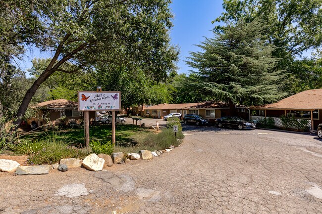


Property Detail
515 Highway 49
035-242-015-000
POR SE1/4 SEC 25 T2N R14E 2.866AC
Multifamilydwelling
Tuolumne
R-2
California
B and X Area of moderate flood hazard, usually the area between the limits of the 100-year and 500-year floods.
2.87 AC
2024
Merced/Central
2025
Other Market Areas
001200
Sonora, CA
NEARBY LISTINGS FOR SALE OR LEASE
DEMOGRAPHICS near 515 Highway 49
1 mile
3 mile
5 mile
2025 Total Population
4,128
12,791
22,325
2030 Population
3,939
12,207
21,248
Pop Growth 2025-2030
(4.58%)
(4.57%)
(4.82%)
Average Age
42
46
46
2025 Total Households
1,898
5,630
9,724
HH Growth 2025-2030
(5.06%)
(4.96%)
(5.24%)
Median Household Inc
$72,468
$84,653
$76,649
Avg Household Size
2.20
2.20
2.20
2025 Avg HH Vehicles
2.00
2.00
2.00
Median Home Value
$435,119
$447,976
$448,264
Median Year Built
1968
1977
1979
Nearby Places
Map Layers
Map Styles
 Street
 Aerial
Transit
 Traffic
 Biking
Places
Listings with unknown addresses are not visible on the map
- Restaurants
- Banks
- Shops
- Fitness
- Groceries
SALE & LEASE HISTORY
LISTING DATE
SALE/LEASE

Aug 23, 2022
For Sale
Nearby Properties
Address
Land Use
TOTAL SIZE
Lot Size
Zoning
Address
Land Use
TOTAL SIZE
Lot Size
Zoning
11.46 AC
C,R-3
Address
Land Use
TOTAL SIZE
Lot Size
Zoning
66,026 SF
2.50 AC
CG
Address
Land Use
TOTAL SIZE
Lot Size
Zoning
45,665 SF
6.53 AC
C-1 & O
Address
Land Use
TOTAL SIZE
Lot Size
Zoning
54,206 SF
4.75 AC
CG
Address
Land Use
TOTAL SIZE
Lot Size
Zoning
165,763 SF
12.91 AC
CG
Address
Land Use
TOTAL SIZE
Lot Size
Zoning
131,601 SF
10.91 AC
C
Address
Land Use
TOTAL SIZE
Lot Size
Zoning
111,559 SF
10.22 AC
ML
Address
Land Use
TOTAL SIZE
Lot Size
Zoning
89,098 SF
2.72 AC
C-O,MX
Address
Land Use
TOTAL SIZE
Lot Size
Zoning
55,300 SF
6.58 AC
C-1 & O-1
Address
Land Use
TOTAL SIZE
Lot Size
Zoning
62,000 SF
5.50 AC
CG
Address
Land Use
TOTAL SIZE
Lot Size
Zoning
22,495 SF
1.74 AC
C-1
Address
Land Use
TOTAL SIZE
Lot Size
Zoning
23,820 SF
1.52 AC
C-1
Address
Land Use
TOTAL SIZE
Lot Size
Zoning
6.70 AC
PD
Address
Land Use
TOTAL SIZE
Lot Size
Zoning
44,730 SF
7.42 AC
C-O
Address
Land Use
TOTAL SIZE
Lot Size
Zoning
106,879 SF
8.10 AC
R-3,D,MX
Address
Land Use
TOTAL SIZE
Lot Size
Zoning
20,419 SF
0.98 AC
CG
Address
Land Use
TOTAL SIZE
Lot Size
Zoning
19,388 SF
1.41 AC
C
Address
Land Use
TOTAL SIZE
Lot Size
Zoning
28,175 SF
2.08 AC
CO
Address
Land Use
TOTAL SIZE
Lot Size
Zoning
58,129 SF
8.24 AC
Address
Land Use
TOTAL SIZE
Lot Size
Zoning
44,235 SF
Address
Land Use
TOTAL SIZE
Lot Size
Zoning
2,324 SF
0.48 AC
C-1,MX
Address
Land Use
TOTAL SIZE
Lot Size
Zoning
4.19 AC
R-3,MX
Address
Land Use
TOTAL SIZE
Lot Size
Zoning
4.89 AC
R-3,MX
Address
Land Use
TOTAL SIZE
Lot Size
Zoning
4.51 AC
R-3,MX
Address
Land Use
TOTAL SIZE
Lot Size
Zoning
11,511 SF
1.41 AC
C-1
Address
Land Use
TOTAL SIZE
Lot Size
Zoning
2,498 SF
0.75 AC
PD
Address
Land Use
TOTAL SIZE
Lot Size
Zoning
62,810 SF
1.56 AC
C-1
Address
Land Use
TOTAL SIZE
Lot Size
Zoning
23,027 SF
0.36 AC
C
Address
Land Use
TOTAL SIZE
Lot Size
Zoning
20,544 SF
23.24 AC
RE-2
The World's #1 Commercial Real Estate Marketplace
Connect with us
© 2026 CoStar Group
The information above has been obtained from sources believed reliable. While we do not doubt its accuracy we have not verified it and make no guarantee, warranty or representation about it. It is your responsibility to independently confirm its accuracy and completeness. Any projections, opinions, assumptions, or estimates used are for example only and do not represent the current or future performance of the property. The value of this transaction to you depends on tax and other factors which should be evaluated by your tax, financial, and legal advisors. You and your advisors should conduct a careful, independent investigation of the property to determine to your satisfaction the suitability of the property for your needs.