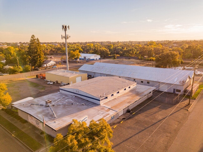
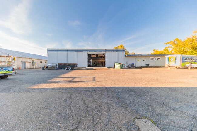
Property Record
515 Sycamore St, Red Bluff, CA 96080

Property Detail
515 Sycamore St
033-061-003-000
ALL OF BLK 41 RED BLUFF
Transportationcommunicationsgeneral
TEHAMA
M-1
California
B and X Area of moderate flood hazard, usually the area between the limits of the 100-year and 500-year floods.
1.71 AC
2025
Redding/Chico
2025
Other Market Areas
000500
Red Bluff, CA
19,520 SF
NEARBY LISTINGS FOR SALE OR LEASE
-
-
View all Red Bluff listings for sale on LoopNet.com
DEMOGRAPHICS near 515 Sycamore St
1 mile
3 mile
5 mile
2025 Total Population
10,773
22,836
26,068
2030 Population
10,922
22,973
26,096
Pop Growth 2025-2030
+ 1.38%
+ 0.60%
+ 0.11%
Average Age
39
40
41
2025 Total Households
4,288
9,006
10,274
HH Growth 2025-2030
+ 1.45%
+ 0.64%
+ 0.15%
Median Household Inc
$44,761
$51,668
$54,259
Avg Household Size
2.50
2.50
2.50
2025 Avg HH Vehicles
1.00
2.00
2.00
Median Home Value
$316,087
$328,836
$343,576
Median Year Built
1975
1978
1978
Nearby Places
Map Layers
Map Styles
 Street
 Aerial
Layers
 Traffic
 Biking
Places
Listings with unknown addresses are not visible on the map
- Restaurants
- Banks
- Shops
- Fitness
- Groceries
PUBLIC TRANSPORTATION
AIRPORT
Redding Regional
Drive
Walk
Distance
Redding Regional
31 min
24.9 mi
Freight Ports
Port of Richmond
Drive
Walk
Distance
Port of Richmond
198 min
174.3 mi
SALE & LEASE HISTORY
LISTING DATE
SALE/LEASE

Oct 29, 2025
For Sale
Nearby Properties
Address
Land Use
TOTAL SIZE
Lot Size
Zoning
Address
Land Use
TOTAL SIZE
Lot Size
Zoning
13.54 AC
C-3
Address
Land Use
TOTAL SIZE
Lot Size
Zoning
189,773 SF
15.37 AC
C-3
Address
Land Use
TOTAL SIZE
Lot Size
Zoning
3,551 SF
99.98 AC
Address
Land Use
TOTAL SIZE
Lot Size
Zoning
154.56 AC
Address
Land Use
TOTAL SIZE
Lot Size
Zoning
5 AC
M2
Address
Land Use
TOTAL SIZE
Lot Size
Zoning
50,720 SF
2.45 AC
F-C
Address
Land Use
TOTAL SIZE
Lot Size
Zoning
2.82 AC
C-1
Address
Land Use
TOTAL SIZE
Lot Size
Zoning
9.13 AC
C-3
Address
Land Use
TOTAL SIZE
Lot Size
Zoning
56,307 SF
4.67 AC
C-3
Address
Land Use
TOTAL SIZE
Lot Size
Zoning
4.45 AC
R-4
Address
Land Use
TOTAL SIZE
Lot Size
Zoning
20.38 AC
C-3
Address
Land Use
TOTAL SIZE
Lot Size
Zoning
102,273 SF
12.42 AC
C-3
Address
Land Use
TOTAL SIZE
Lot Size
Zoning
4.18 AC
Address
Land Use
TOTAL SIZE
Lot Size
Zoning
5.16 AC
R-4
Address
Land Use
TOTAL SIZE
Lot Size
Zoning
43,416 SF
2.85 AC
R-4
Address
Land Use
TOTAL SIZE
Lot Size
Zoning
60,918 SF
5.92 AC
C-3
Address
Land Use
TOTAL SIZE
Lot Size
Zoning
5.04 AC
M-1
Address
Land Use
TOTAL SIZE
Lot Size
Zoning
2.21 AC
C-3
Address
Land Use
TOTAL SIZE
Lot Size
Zoning
6.31 AC
R-4
Address
Land Use
TOTAL SIZE
Lot Size
Zoning
32,502 SF
10.88 AC
F-C
Address
Land Use
TOTAL SIZE
Lot Size
Zoning
9,010 SF
1.20 AC
C-2
Address
Land Use
TOTAL SIZE
Lot Size
Zoning
7.40 AC
M-2
Address
Land Use
TOTAL SIZE
Lot Size
Zoning
4,746 SF
2.17 AC
Address
Land Use
TOTAL SIZE
Lot Size
Zoning
37,296 SF
1.02 AC
C-2
Address
Land Use
TOTAL SIZE
Lot Size
Zoning
11,750 SF
20.37 AC
R1AB435
Address
Land Use
TOTAL SIZE
Lot Size
Zoning
12,394 SF
1.48 AC
C-3
Address
Land Use
TOTAL SIZE
Lot Size
Zoning
1.58 AC
C-3
Address
Land Use
TOTAL SIZE
Lot Size
Zoning
4.49 AC
C-3
Address
Land Use
TOTAL SIZE
Lot Size
Zoning
960 SF
5.94 AC
M1
Address
Land Use
TOTAL SIZE
Lot Size
Zoning
11.42 AC
R-2
The World's #1 Commercial Real Estate Marketplace
Connect with us
© 2026 CoStar Group
The information above has been obtained from sources believed reliable. While we do not doubt its accuracy we have not verified it and make no guarantee, warranty or representation about it. It is your responsibility to independently confirm its accuracy and completeness. Any projections, opinions, assumptions, or estimates used are for example only and do not represent the current or future performance of the property. The value of this transaction to you depends on tax and other factors which should be evaluated by your tax, financial, and legal advisors. You and your advisors should conduct a careful, independent investigation of the property to determine to your satisfaction the suitability of the property for your needs.