Property Record
515 Walnut St, East Liverpool, OH 43920

NEARBY LISTINGS FOR SALE OR LEASE
-
-
View all East Liverpool listings for sale on LoopNet.com
Property Detail
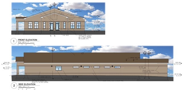
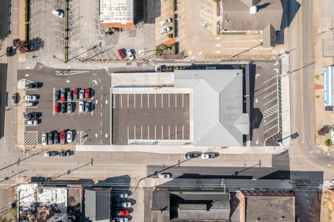
515 Walnut St
3704126000
Blakely And Mitchells Addition
Officebuilding
LOTS 568-575 SMITH, BLAKELEY & MITCHELL ADD. 376.10' WALNUT ST .975 AC
X
Columbiana
42007C0225D
Ohio
2024
0.98 AC
2024
Youngstown/Warren
952100
Other Market Areas
7,680 SF
Salem, OH
DEMOGRAPHICS near 515 Walnut St
1 Mile
3 Mile
5 Mile
2024 Total Population
7,270
21,388
34,027
2029 Population
7,312
21,293
33,766
Pop Growth 2024-2029
+ 0.58%
(0.44%)
(0.77%)
Average Age
41
42
43
2024 Total Households
3,232
9,260
14,599
HH Growth 2024-2029
+ 0.62%
(0.46%)
(0.77%)
Median Household Inc
$25,160
$36,357
$41,442
Avg Household Size
2.20
2.20
2.30
2024 Avg HH Vehicles
1.00
2.00
2.00
Median Home Value
$65,085
$76,991
$87,598
Median Year Built
1948
1953
1957
Nearby Places
Map Layers
Map Styles
 Street
 Aerial
- Restaurants
- Banks
- Shops
- Fitness
- Groceries
PUBLIC TRANSPORTATION
AIRPORT
Pittsburgh International
DRIVE
WALK
Distance
Pittsburgh International
47 min
28.9 mi
SALE & LEASE HISTORY
LISTING DATE
SALE/LEASE

Oct 26, 2020
For Sale
Nearby Properties
Address
Land Use
TOTAL SIZE
Lot Size
Zoning
Address
Land Use
TOTAL SIZE
Lot Size
Zoning
157,837 SF
1.67 AC
Address
Land Use
TOTAL SIZE
Lot Size
Zoning
111.31 AC
Address
Land Use
TOTAL SIZE
Lot Size
Zoning
108,681 SF
33.42 AC
Address
Land Use
TOTAL SIZE
Lot Size
Zoning
14.55 AC
Address
Land Use
TOTAL SIZE
Lot Size
Zoning
75.64 AC
Address
Land Use
TOTAL SIZE
Lot Size
Zoning
2.76 AC
Address
Land Use
TOTAL SIZE
Lot Size
Zoning
17.91 AC
Address
Land Use
TOTAL SIZE
Lot Size
Zoning
25.06 AC
Address
Land Use
TOTAL SIZE
Lot Size
Zoning
3.32 AC
Address
Land Use
TOTAL SIZE
Lot Size
Zoning
66,898 SF
16 AC
Address
Land Use
TOTAL SIZE
Lot Size
Zoning
195,943 SF
22.14 AC
Address
Land Use
TOTAL SIZE
Lot Size
Zoning
1.13 AC
Address
Land Use
TOTAL SIZE
Lot Size
Zoning
38,140 SF
9.85 AC
Address
Land Use
TOTAL SIZE
Lot Size
Zoning
33,563 SF
5.85 AC
Address
Land Use
TOTAL SIZE
Lot Size
Zoning
3,600 SF
3.07 AC
Address
Land Use
TOTAL SIZE
Lot Size
Zoning
1,853 SF
11.62 AC
Address
Land Use
TOTAL SIZE
Lot Size
Zoning
2.32 AC
Address
Land Use
TOTAL SIZE
Lot Size
Zoning
8.22 AC
Address
Land Use
TOTAL SIZE
Lot Size
Zoning
13.59 AC
Address
Land Use
TOTAL SIZE
Lot Size
Zoning
85,013 SF
2.91 AC
Address
Land Use
TOTAL SIZE
Lot Size
Zoning
50,868 SF
0.50 AC
Address
Land Use
TOTAL SIZE
Lot Size
Zoning
7,280 SF
10.58 AC
Address
Land Use
TOTAL SIZE
Lot Size
Zoning
2,400 SF
2 AC
Address
Land Use
TOTAL SIZE
Lot Size
Zoning
7.80 AC
408C
Address
Land Use
TOTAL SIZE
Lot Size
Zoning
7.58 AC
Address
Land Use
TOTAL SIZE
Lot Size
Zoning
0.51 AC
Address
Land Use
TOTAL SIZE
Lot Size
Zoning
23,519 SF
1.04 AC
Address
Land Use
TOTAL SIZE
Lot Size
Zoning
Address
Land Use
TOTAL SIZE
Lot Size
Zoning
Address
Land Use
TOTAL SIZE
Lot Size
Zoning
49,020 SF
0.33 AC
The World's #1 Commercial Real Estate Marketplace
Connect with us
© 2026 CoStar Group
The information above has been obtained from sources believed reliable. While we do not doubt its accuracy we have not verified it and make no guarantee, warranty or representation about it. It is your responsibility to independently confirm its accuracy and completeness. Any projections, opinions, assumptions, or estimates used are for example only and do not represent the current or future performance of the property. The value of this transaction to you depends on tax and other factors which should be evaluated by your tax, financial, and legal advisors. You and your advisors should conduct a careful, independent investigation of the property to determine to your satisfaction the suitability of the property for your needs.