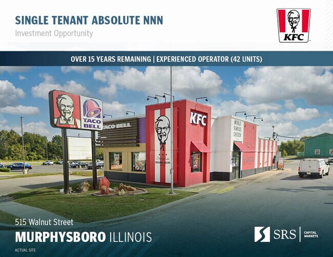
Property Record
515 Walnut St, Murphysboro, IL 62966


Property Detail
515 Walnut St
Carbondale, IL
EAST SIDE ADD NW CORNER OF BLK 1 182.75 N-S X 101' E-W EXC N 5' 856/917 2019R005796
14-04-459-006
Jackson
Commercialnec
Illinois
B and X Area of moderate flood hazard, usually the area between the limits of the 100-year and 500-year floods.
0.41 AC
2024
Marion/I-64 & South
2024
Other Market Areas
010700
NEARBY LISTINGS FOR SALE OR LEASE
DEMOGRAPHICS near 515 Walnut St
1 mile
3 mile
5 mile
2025 Total Population
4,634
10,764
15,856
2030 Population
4,675
10,825
15,924
Pop Growth 2025-2030
+ 0.88%
+ 0.57%
+ 0.43%
Average Age
41
42
43
2025 Total Households
2,023
4,687
6,960
HH Growth 2025-2030
+ 0.74%
+ 0.49%
+ 0.39%
Median Household Inc
$43,377
$50,846
$56,013
Avg Household Size
2.10
2.20
2.10
2025 Avg HH Vehicles
1.00
2.00
2.00
Median Home Value
$77,148
$111,779
$142,092
Median Year Built
1957
1968
1973
Nearby Places
Map Layers
Map Styles
 Street
 Aerial
Transit
 Traffic
 Biking
Places
Listings with unknown addresses are not visible on the map
- Restaurants
- Banks
- Shops
- Fitness
- Groceries
PUBLIC TRANSPORTATION
COMMUTER RAIL
Drive
Walk
Distance
12 min
7.6 mi
SALE & LEASE HISTORY
LISTING DATE
SALE/LEASE

Mar 05, 2019
For Sale
Feb 21, 2024
For Sale
Nearby Properties
Address
Land Use
TOTAL SIZE
Lot Size
Zoning
Address
Land Use
TOTAL SIZE
Lot Size
Zoning
Address
Land Use
TOTAL SIZE
Lot Size
Zoning
Address
Land Use
TOTAL SIZE
Lot Size
Zoning
37.20 AC
Address
Land Use
TOTAL SIZE
Lot Size
Zoning
2.32 AC
Address
Land Use
TOTAL SIZE
Lot Size
Zoning
3,789 SF
9.68 AC
Address
Land Use
TOTAL SIZE
Lot Size
Zoning
12,468 SF
1.14 AC
Address
Land Use
TOTAL SIZE
Lot Size
Zoning
0.28 AC
Address
Land Use
TOTAL SIZE
Lot Size
Zoning
Address
Land Use
TOTAL SIZE
Lot Size
Zoning
5,000 SF
2.60 AC
Address
Land Use
TOTAL SIZE
Lot Size
Zoning
Address
Land Use
TOTAL SIZE
Lot Size
Zoning
2.23 AC
Address
Land Use
TOTAL SIZE
Lot Size
Zoning
0.84 AC
Address
Land Use
TOTAL SIZE
Lot Size
Zoning
13,325 SF
2.31 AC
Address
Land Use
TOTAL SIZE
Lot Size
Zoning
9,000 SF
1.61 AC
Address
Land Use
TOTAL SIZE
Lot Size
Zoning
3.37 AC
Address
Land Use
TOTAL SIZE
Lot Size
Zoning
4,150 SF
0.80 AC
Address
Land Use
TOTAL SIZE
Lot Size
Zoning
1.01 AC
Address
Land Use
TOTAL SIZE
Lot Size
Zoning
0.50 AC
Address
Land Use
TOTAL SIZE
Lot Size
Zoning
Address
Land Use
TOTAL SIZE
Lot Size
Zoning
4,008 SF
2.35 AC
Address
Land Use
TOTAL SIZE
Lot Size
Zoning
1.16 AC
Address
Land Use
TOTAL SIZE
Lot Size
Zoning
4,597 SF
1.19 AC
Address
Land Use
TOTAL SIZE
Lot Size
Zoning
3,070 SF
0.53 AC
Address
Land Use
TOTAL SIZE
Lot Size
Zoning
Address
Land Use
TOTAL SIZE
Lot Size
Zoning
7,563 SF
0.29 AC
Address
Land Use
TOTAL SIZE
Lot Size
Zoning
Address
Land Use
TOTAL SIZE
Lot Size
Zoning
9,230 SF
1.42 AC
Address
Land Use
TOTAL SIZE
Lot Size
Zoning
Address
Land Use
TOTAL SIZE
Lot Size
Zoning
22,500 SF
2.05 AC
The World's #1 Commercial Real Estate Marketplace
Connect with us
© 2026 CoStar Group
The information above has been obtained from sources believed reliable. While we do not doubt its accuracy we have not verified it and make no guarantee, warranty or representation about it. It is your responsibility to independently confirm its accuracy and completeness. Any projections, opinions, assumptions, or estimates used are for example only and do not represent the current or future performance of the property. The value of this transaction to you depends on tax and other factors which should be evaluated by your tax, financial, and legal advisors. You and your advisors should conduct a careful, independent investigation of the property to determine to your satisfaction the suitability of the property for your needs.