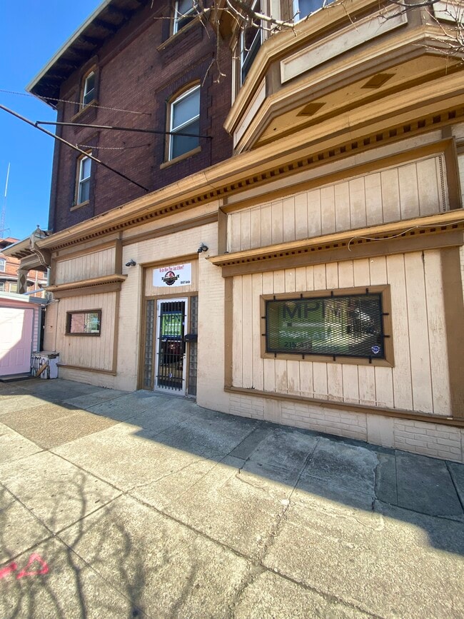
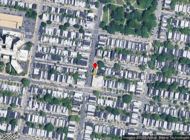
Property Record
5150 Hazel Ave, Philadelphia, PA 19143
NEARBY LISTINGS FOR SALE OR LEASE
Property Detail
5150 Hazel Ave
871213250
SOUTHEAST COR 52ND
Commercialnec
Philadelphia
X
Pennsylvania
42045C0128F
37
2024
0.04 AC
2026
West Philadelphia
008000
Philadelphia
3,888 SF
Philadelphia-Camden-Wilmington, PA-NJ-DE-MD
DEMOGRAPHICS near 5150 Hazel Ave
1 Mile
3 Mile
5 Mile
2024 Total Population
79,476
422,712
931,482
2029 Population
77,073
412,662
913,814
Pop Growth 2024-2029
(3.02%)
(2.38%)
(1.90%)
Average Age
37
37
38
2024 Total Households
33,296
173,694
391,935
HH Growth 2024-2029
(3.26%)
(2.65%)
(2.17%)
Median Household Inc
$41,735
$48,799
$60,313
Avg Household Size
2.30
2.30
2.20
2024 Avg HH Vehicles
1.00
1.00
1.00
Median Home Value
$154,496
$179,261
$250,312
Median Year Built
1946
1948
1949
Nearby Places
Map Layers
Map Styles
 Street
 Aerial
- Restaurants
- Banks
- Shops
- Fitness
- Groceries
PUBLIC TRANSPORTATION
TRANSIT/SUBWAY
Baltimore Avenue And 52Nd Street (Route 34 - Southeastern Pennsylvania Transportation Authority Rapid Transit (SEPTA Subway & Trolley))
DRIVE
WALK
Distance
Baltimore Avenue And 52Nd Street (Route 34 - Southeastern Pennsylvania Transportation Authority Rapid Transit (SEPTA Subway & Trolley))
0 min
4 min
0.2 mi
Baltimore Avenue And 51St Street (Route 34 - Southeastern Pennsylvania Transportation Authority Rapid Transit (SEPTA Subway & Trolley))
DRIVE
WALK
Distance
Baltimore Avenue And 51St Street (Route 34 - Southeastern Pennsylvania Transportation Authority Rapid Transit (SEPTA Subway & Trolley))
1 min
6 min
0.3 mi
Baltimore Avenue And 53Rd Street (Route 34 - Southeastern Pennsylvania Transportation Authority Rapid Transit (SEPTA Subway & Trolley))
DRIVE
WALK
Distance
Baltimore Avenue And 53Rd Street (Route 34 - Southeastern Pennsylvania Transportation Authority Rapid Transit (SEPTA Subway & Trolley))
1 min
6 min
0.3 mi
Baltimore Avenue And 50Th Street (Route 34 - Southeastern Pennsylvania Transportation Authority Rapid Transit (SEPTA Subway & Trolley))
DRIVE
WALK
Distance
Baltimore Avenue And 50Th Street (Route 34 - Southeastern Pennsylvania Transportation Authority Rapid Transit (SEPTA Subway & Trolley))
1 min
7 min
0.4 mi
Baltimore Avenue And 54Th Street (Route 34 - Southeastern Pennsylvania Transportation Authority Rapid Transit (SEPTA Subway & Trolley))
DRIVE
WALK
Distance
Baltimore Avenue And 54Th Street (Route 34 - Southeastern Pennsylvania Transportation Authority Rapid Transit (SEPTA Subway & Trolley))
1 min
8 min
0.4 mi
COMMUTER RAIL
49Th Street (R3 - Southeastern Pennsylvania Transportation Authority Regional Rail (SEPTA Regional Rail))
DRIVE
WALK
Distance
49Th Street (R3 - Southeastern Pennsylvania Transportation Authority Regional Rail (SEPTA Regional Rail))
2 min
17 min
0.9 mi
Angora (R3 - Southeastern Pennsylvania Transportation Authority Regional Rail (SEPTA Regional Rail))
DRIVE
WALK
Distance
Angora (R3 - Southeastern Pennsylvania Transportation Authority Regional Rail (SEPTA Regional Rail))
3 min
20 min
1.0 mi
AIRPORT
Philadelphia International
DRIVE
WALK
Distance
Philadelphia International
17 min
7.5 mi
Freight Ports
South Jersey Port
DRIVE
WALK
Distance
South Jersey Port
18 min
8.6 mi
SALE & LEASE HISTORY
LISTING DATE
SALE/LEASE

Mar 04, 2022
For Lease
Nearby Properties
Address
Land Use
TOTAL SIZE
Lot Size
Zoning
Address
Land Use
TOTAL SIZE
Lot Size
Zoning
1,076,400 SF
5 AC
CMX4
Address
Land Use
TOTAL SIZE
Lot Size
Zoning
26,690 SF
500 AC
SPINS
Address
Land Use
TOTAL SIZE
Lot Size
Zoning
1,103,300 SF
1.18 AC
CMX5
Address
Land Use
TOTAL SIZE
Lot Size
Zoning
319,590 SF
0.87 AC
I2
Address
Land Use
TOTAL SIZE
Lot Size
Zoning
760,635 SF
0.77 AC
CMX5
Address
Land Use
TOTAL SIZE
Lot Size
Zoning
1,179,072 SF
8.90 AC
RM4
Address
Land Use
TOTAL SIZE
Lot Size
Zoning
782,208 SF
0.68 AC
CMX5
Address
Land Use
TOTAL SIZE
Lot Size
Zoning
500,165 SF
2.16 AC
SPPOA
Address
Land Use
TOTAL SIZE
Lot Size
Zoning
1,152,520 SF
1.49 AC
CMX5
Address
Land Use
TOTAL SIZE
Lot Size
Zoning
696,920 SF
10.55 AC
SPINS
Address
Land Use
TOTAL SIZE
Lot Size
Zoning
1,143,040 SF
0.81 AC
CMX5
Address
Land Use
TOTAL SIZE
Lot Size
Zoning
700,000 SF
7.88 AC
CMX5
Address
Land Use
TOTAL SIZE
Lot Size
Zoning
738,207 SF
0.89 AC
CMX5
Address
Land Use
TOTAL SIZE
Lot Size
Zoning
1,152,480 SF
1.48 AC
CMX5
Address
Land Use
TOTAL SIZE
Lot Size
Zoning
391,440 SF
1.72 AC
SPINS
Address
Land Use
TOTAL SIZE
Lot Size
Zoning
600,523 SF
1.85 AC
CMX4
Address
Land Use
TOTAL SIZE
Lot Size
Zoning
385,000 SF
2.49 AC
SPINS
Address
Land Use
TOTAL SIZE
Lot Size
Zoning
376,874 SF
3.14 AC
SPINS
Address
Land Use
TOTAL SIZE
Lot Size
Zoning
375,500 SF
1.40 AC
CMX5
Address
Land Use
TOTAL SIZE
Lot Size
Zoning
373,040 SF
4.17 AC
SPINS
Address
Land Use
TOTAL SIZE
Lot Size
Zoning
400,000 SF
3.32 AC
CMX5
Address
Land Use
TOTAL SIZE
Lot Size
Zoning
685,000 SF
47.69 AC
CMX3
Address
Land Use
TOTAL SIZE
Lot Size
Zoning
455,000 SF
0.77 AC
CMX5
Address
Land Use
TOTAL SIZE
Lot Size
Zoning
330,183 SF
0.61 AC
CMX4
Address
Land Use
TOTAL SIZE
Lot Size
Zoning
1,588,163 SF
7.28 AC
SPINS
Address
Land Use
TOTAL SIZE
Lot Size
Zoning
623,182 SF
0.98 AC
CMX5
Address
Land Use
TOTAL SIZE
Lot Size
Zoning
303,750 SF
1.36 AC
SPINS
Address
Land Use
TOTAL SIZE
Lot Size
Zoning
552,275 SF
1 AC
CMX3
Address
Land Use
TOTAL SIZE
Lot Size
Zoning
3.02 AC
RMX3
Address
Land Use
TOTAL SIZE
Lot Size
Zoning
239,760 SF
5.51 AC
SPINS
The World's #1 Commercial Real Estate Marketplace
Connect with us
© 2025 CoStar Group
The information above has been obtained from sources believed reliable. While we do not doubt its accuracy we have not verified it and make no guarantee, warranty or representation about it. It is your responsibility to independently confirm its accuracy and completeness. Any projections, opinions, assumptions, or estimates used are for example only and do not represent the current or future performance of the property. The value of this transaction to you depends on tax and other factors which should be evaluated by your tax, financial, and legal advisors. You and your advisors should conduct a careful, independent investigation of the property to determine to your satisfaction the suitability of the property for your needs.