Property Record
5150 Linwood Rd, Placida, FL 33946

NEARBY LISTINGS FOR SALE OR LEASE
Property Detail
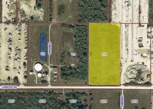
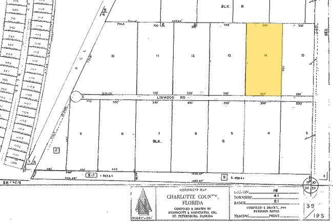
5150 Linwood Rd
Punta Gorda, FL
Lemon Bay Groves
412119477002
LEMON BAY GROVES UNIT 1 TRACT 14 5 AC. M/L LESS THE ELY 123.74 AS DESC IN OR 4419/454 207/403 641/413 1035/113 2173/1320 2249/254 3077/2035 3535/782
Industrialacreage
Charlotte
AE
Florida
12015C0213G
3.14 AC
2024
Charlotte County
2025
Southwest Florida
030504
DEMOGRAPHICS near 5150 Linwood Rd
1 Mile
3 Mile
5 Mile
2024 Total Population
3,037
21,102
44,665
2029 Population
3,813
25,970
54,394
Pop Growth 2024-2029
+ 25.55%
+ 23.07%
+ 21.78%
Average Age
60
57
56
2024 Total Households
1,440
9,808
21,086
HH Growth 2024-2029
+ 25.83%
+ 23.26%
+ 21.98%
Median Household Inc
$70,637
$69,037
$61,668
Avg Household Size
2.10
2.10
2.10
2024 Avg HH Vehicles
2.00
2.00
2.00
Median Home Value
$350,365
$322,878
$285,681
Median Year Built
2009
2004
1997
Nearby Places
Map Layers
Map Styles
 Street
 Aerial
- Restaurants
- Banks
- Shops
- Fitness
- Groceries
PUBLIC TRANSPORTATION
AIRPORT
Punta Gorda
DRIVE
WALK
Distance
Punta Gorda
42 min
24.1 mi
Freight Ports
Port Manatee
DRIVE
WALK
Distance
Port Manatee
91 min
66.0 mi
Nearby Properties
Address
Land Use
TOTAL SIZE
Lot Size
Zoning
Address
Land Use
TOTAL SIZE
Lot Size
Zoning
99,840 SF
7.60 AC
IG
Address
Land Use
TOTAL SIZE
Lot Size
Zoning
108,048 SF
14.84 AC
CG
Address
Land Use
TOTAL SIZE
Lot Size
Zoning
42,935 SF
167.66 AC
RE1
Address
Land Use
TOTAL SIZE
Lot Size
Zoning
1,200 SF
29.50 AC
CG
Address
Land Use
TOTAL SIZE
Lot Size
Zoning
20.12 AC
CG
Address
Land Use
TOTAL SIZE
Lot Size
Zoning
24,708 SF
14.89 AC
CT
Address
Land Use
TOTAL SIZE
Lot Size
Zoning
11,718 SF
0.15 AC
WDR4*
Address
Land Use
TOTAL SIZE
Lot Size
Zoning
38.14 AC
IG
Address
Land Use
TOTAL SIZE
Lot Size
Zoning
12,300 SF
5.02 AC
IG
Address
Land Use
TOTAL SIZE
Lot Size
Zoning
6,476 SF
17.26 AC
II
Address
Land Use
TOTAL SIZE
Lot Size
Zoning
4,776 SF
20 AC
II
Address
Land Use
TOTAL SIZE
Lot Size
Zoning
2,940 SF
332.40 AC
RSF5
Address
Land Use
TOTAL SIZE
Lot Size
Zoning
560 SF
10.23 AC
IG
Address
Land Use
TOTAL SIZE
Lot Size
Zoning
16.53 AC
CG
Address
Land Use
TOTAL SIZE
Lot Size
Zoning
20,650 SF
1.61 AC
CG
Address
Land Use
TOTAL SIZE
Lot Size
Zoning
5,222 SF
85.60 AC
RMF10
Address
Land Use
TOTAL SIZE
Lot Size
Zoning
1,430 SF
5.98 AC
CG
Address
Land Use
TOTAL SIZE
Lot Size
Zoning
6,852 SF
161.47 AC
RSF5
Address
Land Use
TOTAL SIZE
Lot Size
Zoning
12,907 SF
165.69 AC
RSF5
Address
Land Use
TOTAL SIZE
Lot Size
Zoning
18,599 SF
1.96 AC
IG
Address
Land Use
TOTAL SIZE
Lot Size
Zoning
576 SF
5 AC
II
Address
Land Use
TOTAL SIZE
Lot Size
Zoning
11,550 SF
1.18 AC
CG
Address
Land Use
TOTAL SIZE
Lot Size
Zoning
10.88 AC
CG
Address
Land Use
TOTAL SIZE
Lot Size
Zoning
11,708 SF
9.99 AC
II
Address
Land Use
TOTAL SIZE
Lot Size
Zoning
4,000 SF
7.78 AC
RMF10
Address
Land Use
TOTAL SIZE
Lot Size
Zoning
13.29 AC
CG
Address
Land Use
TOTAL SIZE
Lot Size
Zoning
3,589 SF
1.47 AC
CG
Address
Land Use
TOTAL SIZE
Lot Size
Zoning
15,000 SF
1.62 AC
IG
Address
Land Use
TOTAL SIZE
Lot Size
Zoning
7.71 AC
CG
Address
Land Use
TOTAL SIZE
Lot Size
Zoning
15,787 SF
1.46 AC
IG
The World's #1 Commercial Real Estate Marketplace
Connect with us
© 2025 CoStar Group
The information above has been obtained from sources believed reliable. While we do not doubt its accuracy we have not verified it and make no guarantee, warranty or representation about it. It is your responsibility to independently confirm its accuracy and completeness. Any projections, opinions, assumptions, or estimates used are for example only and do not represent the current or future performance of the property. The value of this transaction to you depends on tax and other factors which should be evaluated by your tax, financial, and legal advisors. You and your advisors should conduct a careful, independent investigation of the property to determine to your satisfaction the suitability of the property for your needs.