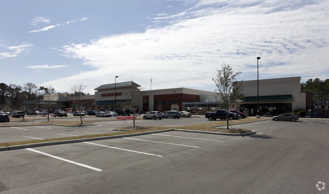
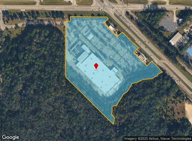
Property Record
5150 Nw 13Th St, Gainesville, FL 32609

NEARBY LISTINGS FOR SALE OR LEASE
Property Detail
5150 Nw 13Th St
07883-010-003
Minor S/D
Departmentstore
MSD BK 2 PG 84 PARCEL 3
X
Alachua
12001C0303E
Florida
2025
15.07 AC
2025
Northwest Gainesville
001203
Other Market Areas
100,179 SF
Gainesville, FL
DEMOGRAPHICS near 5150 Nw 13Th St
1 Mile
3 Mile
5 Mile
2024 Total Population
4,808
42,580
112,741
2029 Population
5,081
44,931
118,172
Pop Growth 2024-2029
+ 5.68%
+ 5.52%
+ 4.82%
Average Age
39
40
36
2024 Total Households
2,171
19,066
45,595
HH Growth 2024-2029
+ 5.85%
+ 5.64%
+ 5.13%
Median Household Inc
$57,377
$62,581
$49,040
Avg Household Size
2.20
2.20
2.20
2024 Avg HH Vehicles
2.00
2.00
2.00
Median Home Value
$180,405
$207,395
$219,679
Median Year Built
1983
1979
1979
Nearby Places
Map Layers
Map Styles
 Street
 Aerial
- Restaurants
- Banks
- Shops
- Fitness
- Groceries
PUBLIC TRANSPORTATION
AIRPORT
Gainesville Regional
DRIVE
WALK
Distance
Gainesville Regional
14 min
5.5 mi
Freight Ports
Jacksonville Port
DRIVE
WALK
Distance
Jacksonville Port
99 min
75.3 mi
Nearby Properties
Address
Land Use
TOTAL SIZE
Lot Size
Zoning
Address
Land Use
TOTAL SIZE
Lot Size
Zoning
1,331,605 SF
32.61 AC
ED
Address
Land Use
TOTAL SIZE
Lot Size
Zoning
395,561 SF
19.11 AC
PD
Address
Land Use
TOTAL SIZE
Lot Size
Zoning
60,480 SF
117.68 AC
PS
Address
Land Use
TOTAL SIZE
Lot Size
Zoning
346,154 SF
22.02 AC
U6
Address
Land Use
TOTAL SIZE
Lot Size
Zoning
378,985 SF
7.21 AC
PD
Address
Land Use
TOTAL SIZE
Lot Size
Zoning
385,880 SF
21.51 AC
PD
Address
Land Use
TOTAL SIZE
Lot Size
Zoning
254,026 SF
24.75 AC
RMF6
Address
Land Use
TOTAL SIZE
Lot Size
Zoning
125,495 SF
19.11 AC
ED
Address
Land Use
TOTAL SIZE
Lot Size
Zoning
233,458 SF
16.30 AC
PD
Address
Land Use
TOTAL SIZE
Lot Size
Zoning
93,004 SF
37.39 AC
ED
Address
Land Use
TOTAL SIZE
Lot Size
Zoning
206,923 SF
15.32 AC
ED
Address
Land Use
TOTAL SIZE
Lot Size
Zoning
188,858 SF
15 AC
ED
Address
Land Use
TOTAL SIZE
Lot Size
Zoning
90,488 SF
14.67 AC
ED
Address
Land Use
TOTAL SIZE
Lot Size
Zoning
174,781 SF
16.83 AC
U8
Address
Land Use
TOTAL SIZE
Lot Size
Zoning
74,722 SF
9.71 AC
PD
Address
Land Use
TOTAL SIZE
Lot Size
Zoning
169,796 SF
15.61 AC
U8
Address
Land Use
TOTAL SIZE
Lot Size
Zoning
152,739 SF
15.30 AC
RMF6
Address
Land Use
TOTAL SIZE
Lot Size
Zoning
69,139 SF
2.18 AC
I1
Address
Land Use
TOTAL SIZE
Lot Size
Zoning
34.32 AC
PS
Address
Land Use
TOTAL SIZE
Lot Size
Zoning
80,995 SF
9.59 AC
MU1
Address
Land Use
TOTAL SIZE
Lot Size
Zoning
136,094 SF
16.11 AC
ED
Address
Land Use
TOTAL SIZE
Lot Size
Zoning
129,624 SF
11.27 AC
RMF7
Address
Land Use
TOTAL SIZE
Lot Size
Zoning
58,472 SF
14.89 AC
ED
Address
Land Use
TOTAL SIZE
Lot Size
Zoning
103,590 SF
12.68 AC
R-2
Address
Land Use
TOTAL SIZE
Lot Size
Zoning
162,621 SF
15 AC
RMF6
Address
Land Use
TOTAL SIZE
Lot Size
Zoning
113,378 SF
13.75 AC
RMF6
Address
Land Use
TOTAL SIZE
Lot Size
Zoning
116,479 SF
12.23 AC
U8
Address
Land Use
TOTAL SIZE
Lot Size
Zoning
136,858 SF
15.85 AC
U8
Address
Land Use
TOTAL SIZE
Lot Size
Zoning
138,032 SF
32 AC
MH
Address
Land Use
TOTAL SIZE
Lot Size
Zoning
93,250 SF
2.20 AC
BA
The World's #1 Commercial Real Estate Marketplace
Connect with us
© 2025 CoStar Group
The information above has been obtained from sources believed reliable. While we do not doubt its accuracy we have not verified it and make no guarantee, warranty or representation about it. It is your responsibility to independently confirm its accuracy and completeness. Any projections, opinions, assumptions, or estimates used are for example only and do not represent the current or future performance of the property. The value of this transaction to you depends on tax and other factors which should be evaluated by your tax, financial, and legal advisors. You and your advisors should conduct a careful, independent investigation of the property to determine to your satisfaction the suitability of the property for your needs.