Property Record
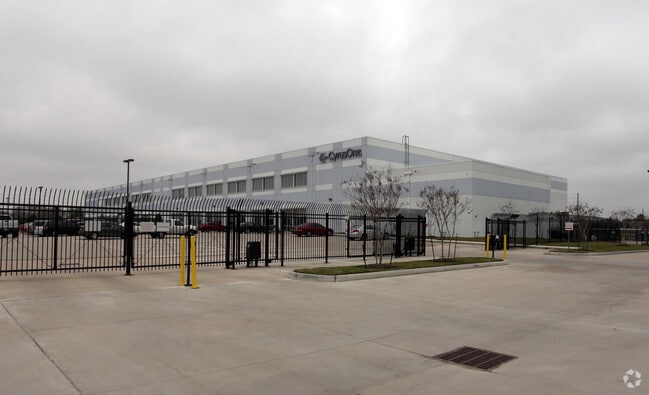
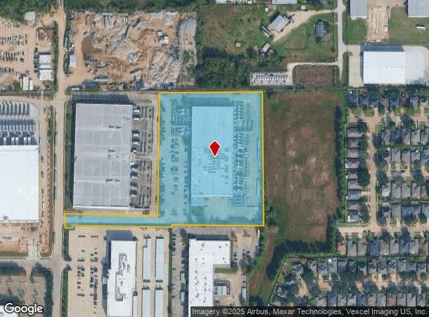
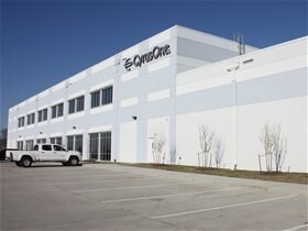
5150 Westway Park Blvd, Houston, TX 77041

NEARBY LISTINGS FOR SALE OR LEASE
Property Detail
5150 Westway Park Blvd
Houston-The Woodlands-Sugar Land, TX
At Spring Shadows Sec 2 Beltway Eight Co
1246190010004
Harris
Notresolvable
Texas
X
8.07 AC
48201C0635M
Northwest Inner Loop
172,326 SF
Houston
DEMOGRAPHICS near 5150 Westway Park Blvd
1 Mile
3 Mile
5 Mile
2024 Total Population
7,996
68,908
263,766
2029 Population
8,227
70,489
269,097
Pop Growth 2024-2029
+ 2.89%
+ 2.29%
+ 2.02%
Average Age
39
37
37
2024 Total Households
2,672
24,659
95,359
HH Growth 2024-2029
+ 2.99%
+ 2.35%
+ 2.06%
Median Household Inc
$64,282
$66,529
$64,158
Avg Household Size
2.80
2.70
2.70
2024 Avg HH Vehicles
2.00
2.00
2.00
Median Home Value
$196,688
$283,557
$269,645
Median Year Built
1983
1978
1982
Nearby Places
Map Layers
Map Styles
 Street
 Aerial
- Restaurants
- Banks
- Shops
- Fitness
- Groceries
PUBLIC TRANSPORTATION
AIRPORT
George Bush Intcntl/Houston
DRIVE
WALK
Distance
George Bush Intcntl/Houston
31 min
24.0 mi
William P Hobby
DRIVE
WALK
Distance
William P Hobby
48 min
30.1 mi
Freight Ports
Port of Houston
DRIVE
WALK
Distance
Port of Houston
39 min
25.3 mi
Nearby Properties
Address
Land Use
TOTAL SIZE
Lot Size
Zoning
Address
Land Use
TOTAL SIZE
Lot Size
Zoning
578,530 SF
32.81 AC
Address
Land Use
TOTAL SIZE
Lot Size
Zoning
793,669 SF
121.83 AC
Address
Land Use
TOTAL SIZE
Lot Size
Zoning
519,220 SF
6.23 AC
Address
Land Use
TOTAL SIZE
Lot Size
Zoning
643,804 SF
31.40 AC
Address
Land Use
TOTAL SIZE
Lot Size
Zoning
380,959 SF
21.43 AC
Address
Land Use
TOTAL SIZE
Lot Size
Zoning
342,163 SF
8.50 AC
Address
Land Use
TOTAL SIZE
Lot Size
Zoning
427,921 SF
18.14 AC
Address
Land Use
TOTAL SIZE
Lot Size
Zoning
336,681 SF
16.10 AC
Address
Land Use
TOTAL SIZE
Lot Size
Zoning
Address
Land Use
TOTAL SIZE
Lot Size
Zoning
300,348 SF
6.10 AC
Address
Land Use
TOTAL SIZE
Lot Size
Zoning
456,294 SF
19.02 AC
Address
Land Use
TOTAL SIZE
Lot Size
Zoning
647,228 SF
9.85 AC
Address
Land Use
TOTAL SIZE
Lot Size
Zoning
408,730 SF
24.68 AC
Address
Land Use
TOTAL SIZE
Lot Size
Zoning
802,913 SF
27.11 AC
Address
Land Use
TOTAL SIZE
Lot Size
Zoning
281,843 SF
13.97 AC
Address
Land Use
TOTAL SIZE
Lot Size
Zoning
312,065 SF
17.83 AC
Address
Land Use
TOTAL SIZE
Lot Size
Zoning
426,748 SF
26.09 AC
Address
Land Use
TOTAL SIZE
Lot Size
Zoning
401,600 SF
20.48 AC
Address
Land Use
TOTAL SIZE
Lot Size
Zoning
350,057 SF
19.96 AC
Address
Land Use
TOTAL SIZE
Lot Size
Zoning
Address
Land Use
TOTAL SIZE
Lot Size
Zoning
347,694 SF
17.61 AC
Address
Land Use
TOTAL SIZE
Lot Size
Zoning
327,674 SF
15.32 AC
Address
Land Use
TOTAL SIZE
Lot Size
Zoning
185,252 SF
17.14 AC
Address
Land Use
TOTAL SIZE
Lot Size
Zoning
287,212 SF
12.52 AC
Address
Land Use
TOTAL SIZE
Lot Size
Zoning
472,988 SF
9 AC
Address
Land Use
TOTAL SIZE
Lot Size
Zoning
212,017 SF
14.11 AC
Address
Land Use
TOTAL SIZE
Lot Size
Zoning
251,461 SF
21.74 AC
Address
Land Use
TOTAL SIZE
Lot Size
Zoning
418,892 SF
19.81 AC
Address
Land Use
TOTAL SIZE
Lot Size
Zoning
358,361 SF
11.35 AC
Address
Land Use
TOTAL SIZE
Lot Size
Zoning
403,200 SF
20.53 AC
The World's #1 Commercial Real Estate Marketplace
Connect with us
© 2026 CoStar Group
The information above has been obtained from sources believed reliable. While we do not doubt its accuracy we have not verified it and make no guarantee, warranty or representation about it. It is your responsibility to independently confirm its accuracy and completeness. Any projections, opinions, assumptions, or estimates used are for example only and do not represent the current or future performance of the property. The value of this transaction to you depends on tax and other factors which should be evaluated by your tax, financial, and legal advisors. You and your advisors should conduct a careful, independent investigation of the property to determine to your satisfaction the suitability of the property for your needs.