Property Record
5151 Buffalo Rd, Erie, PA 16510

NEARBY LISTINGS FOR SALE OR LEASE
-
-
View all Erie listings for sale on LoopNet.com
Property Detail
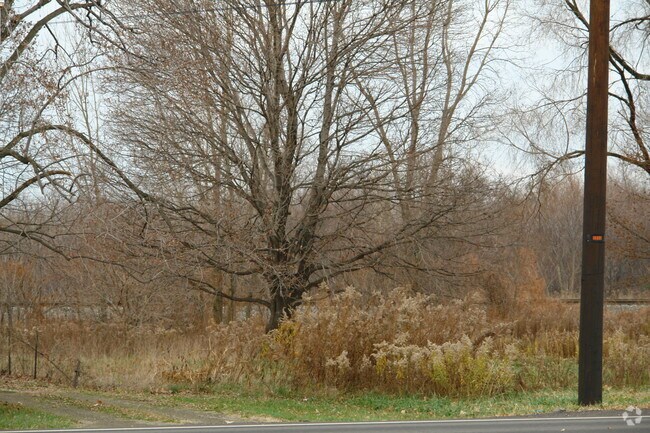
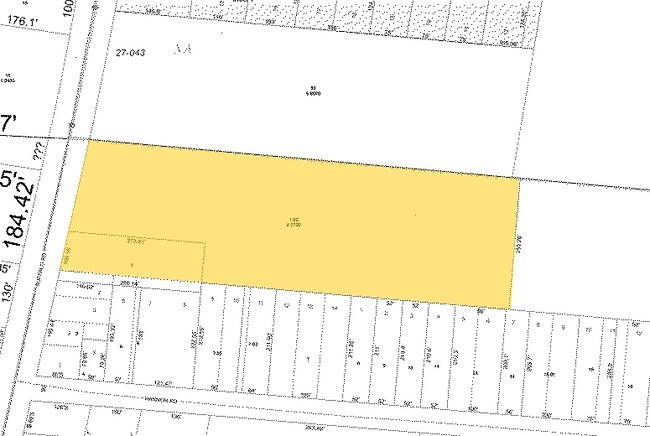
5151 Buffalo Rd
27-037-136.0-001.00
D L Adams Subdivision #2
Funeralhome
5151 BUFFALO RD 6.32 AC NET
X
Erie
42049C0090D
Pennsylvania
2025
6.32 AC
2025
Outlying Erie County
011510
Erie
11,248 SF
Erie, PA
DEMOGRAPHICS near 5151 Buffalo Rd
1 Mile
3 Mile
5 Mile
2024 Total Population
2,594
28,626
68,516
2029 Population
2,568
28,336
67,629
Pop Growth 2024-2029
(1.00%)
(1.01%)
(1.29%)
Average Age
43
41
39
2024 Total Households
1,022
10,927
26,319
HH Growth 2024-2029
(1.17%)
(1.12%)
(1.45%)
Median Household Inc
$81,159
$60,311
$49,722
Avg Household Size
2.40
2.40
2.40
2024 Avg HH Vehicles
2.00
2.00
2.00
Median Home Value
$186,519
$150,278
$123,464
Median Year Built
1974
1965
1958
Nearby Places
Map Layers
Map Styles
 Street
 Aerial
- Restaurants
- Banks
- Shops
- Fitness
- Groceries
PUBLIC TRANSPORTATION
COMMUTER RAIL
Erie Amtrak Station (Lake Shore Limited - Amtrak)
DRIVE
WALK
Distance
Erie Amtrak Station (Lake Shore Limited - Amtrak)
14 min
6.7 mi
AIRPORT
Erie International/Tom Ridge Field
DRIVE
WALK
Distance
Erie International/Tom Ridge Field
25 min
12.4 mi
Freight Ports
Port of Toledo
DRIVE
WALK
Distance
Port of Toledo
261 min
220.4 mi
Nearby Properties
Address
Land Use
TOTAL SIZE
Lot Size
Zoning
Address
Land Use
TOTAL SIZE
Lot Size
Zoning
227,630 SF
343.90 AC
I1
Address
Land Use
TOTAL SIZE
Lot Size
Zoning
68,626 SF
86.88 AC
B1
Address
Land Use
TOTAL SIZE
Lot Size
Zoning
75.24 AC
R2A
Address
Land Use
TOTAL SIZE
Lot Size
Zoning
92,635 SF
8.45 AC
B1
Address
Land Use
TOTAL SIZE
Lot Size
Zoning
23.31 AC
C1
Address
Land Use
TOTAL SIZE
Lot Size
Zoning
59,300 SF
16.25 AC
Address
Land Use
TOTAL SIZE
Lot Size
Zoning
9.38 AC
C1
Address
Land Use
TOTAL SIZE
Lot Size
Zoning
92,284 SF
3.94 AC
B3
Address
Land Use
TOTAL SIZE
Lot Size
Zoning
118,270 SF
5.64 AC
R2A
Address
Land Use
TOTAL SIZE
Lot Size
Zoning
121,197 SF
7.58 AC
Address
Land Use
TOTAL SIZE
Lot Size
Zoning
62.79 AC
R2B
Address
Land Use
TOTAL SIZE
Lot Size
Zoning
41,976 SF
6.50 AC
R2A
Address
Land Use
TOTAL SIZE
Lot Size
Zoning
189,305 SF
42.45 AC
B1
Address
Land Use
TOTAL SIZE
Lot Size
Zoning
4.76 AC
R3
Address
Land Use
TOTAL SIZE
Lot Size
Zoning
13,620 SF
1.21 AC
B1
Address
Land Use
TOTAL SIZE
Lot Size
Zoning
202,500 SF
46.30 AC
I
Address
Land Use
TOTAL SIZE
Lot Size
Zoning
51.13 AC
R2A
Address
Land Use
TOTAL SIZE
Lot Size
Zoning
71,380 SF
6.66 AC
B1
Address
Land Use
TOTAL SIZE
Lot Size
Zoning
75,487 SF
7.32 AC
R3
Address
Land Use
TOTAL SIZE
Lot Size
Zoning
70,022 SF
9.07 AC
B1
Address
Land Use
TOTAL SIZE
Lot Size
Zoning
65,776 SF
5.76 AC
B1
Address
Land Use
TOTAL SIZE
Lot Size
Zoning
66,381 SF
1.90 AC
R1
Address
Land Use
TOTAL SIZE
Lot Size
Zoning
37,926 SF
52.49 AC
R2A
Address
Land Use
TOTAL SIZE
Lot Size
Zoning
10.50 AC
R2A
Address
Land Use
TOTAL SIZE
Lot Size
Zoning
46,032 SF
2.13 AC
R3
Address
Land Use
TOTAL SIZE
Lot Size
Zoning
30,144 SF
3.03 AC
I
Address
Land Use
TOTAL SIZE
Lot Size
Zoning
29,376 SF
4.15 AC
R3
Address
Land Use
TOTAL SIZE
Lot Size
Zoning
48,432 SF
6.71 AC
R3
Address
Land Use
TOTAL SIZE
Lot Size
Zoning
273,835 SF
23.05 AC
R1
Address
Land Use
TOTAL SIZE
Lot Size
Zoning
32,200 SF
13.90 AC
R2B
The World's #1 Commercial Real Estate Marketplace
Connect with us
© 2026 CoStar Group
The information above has been obtained from sources believed reliable. While we do not doubt its accuracy we have not verified it and make no guarantee, warranty or representation about it. It is your responsibility to independently confirm its accuracy and completeness. Any projections, opinions, assumptions, or estimates used are for example only and do not represent the current or future performance of the property. The value of this transaction to you depends on tax and other factors which should be evaluated by your tax, financial, and legal advisors. You and your advisors should conduct a careful, independent investigation of the property to determine to your satisfaction the suitability of the property for your needs.