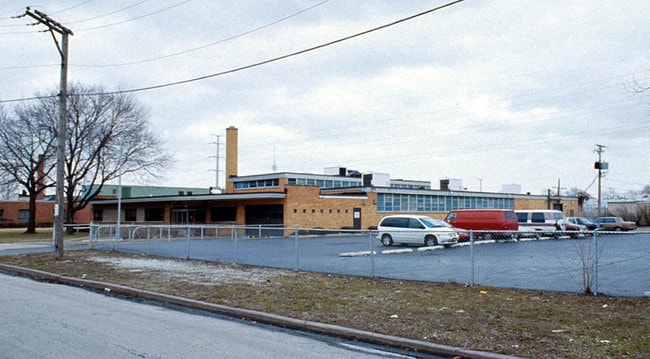
Property Record
5151 S Millard Ave, Chicago, IL 60632


Current Lease Availabilities
Property Detail
5151 S Millard Ave
Industrialgeneral
COOK
M1-1
Illinois
B and X Area of moderate flood hazard, usually the area between the limits of the 100-year and 500-year floods.
0.95 AC
2023
South Chicago
2025
Chicago
580400
Chicago-Naperville-Elgin, IL-IN
19,284 SF
19-11-309-023-0000
NEARBY LISTINGS FOR SALE OR LEASE
DEMOGRAPHICS near 5151 S Millard Ave
1 mile
3 mile
5 mile
2025 Total Population
39,314
261,189
687,449
2030 Population
37,220
249,028
664,531
Pop Growth 2025-2030
(5.33%)
(4.66%)
(3.33%)
Average Age
36
36
38
2025 Total Households
10,632
75,641
222,987
HH Growth 2025-2030
(5.72%)
(5.04%)
(3.51%)
Median Household Inc
$66,349
$58,815
$58,864
Avg Household Size
3.50
3.30
2.90
2025 Avg HH Vehicles
2.00
1.00
1.00
Median Home Value
$251,546
$245,674
$252,676
Median Year Built
1949
1949
1949
Nearby Places
Map Layers
Map Styles
 Street
 Aerial
Layers
 Traffic
 Biking
Places
Listings with unknown addresses are not visible on the map
- Restaurants
- Banks
- Shops
- Fitness
- Groceries
PUBLIC TRANSPORTATION
TRANSIT/SUBWAY
Pulaski Station (Orange Line) (Orange Line - Chicago Transit Authority "L" Trains (The "L"))
Drive
Walk
Distance
Pulaski Station (Orange Line) (Orange Line - Chicago Transit Authority "L" Trains (The "L"))
4 min
14 min
0.7 mi
Kedzie Station (Orange Line) (Orange Line - Chicago Transit Authority "L" Trains (The "L"))
Drive
Walk
Distance
Kedzie Station (Orange Line) (Orange Line - Chicago Transit Authority "L" Trains (The "L"))
2 min
18 min
1.0 mi
COMMUTER RAIL
Wrightwood Station (SouthWest Service - Northeast Illinois Regional Commuter Railroad (Metra))
Drive
Walk
Distance
Wrightwood Station (SouthWest Service - Northeast Illinois Regional Commuter Railroad (Metra))
9 min
4.2 mi
Cicero Station (Burlington Northern-Santa Fe Railway Line - Northeast Illinois Regional Commuter Railroad (Metra))
Drive
Walk
Distance
Cicero Station (Burlington Northern-Santa Fe Railway Line - Northeast Illinois Regional Commuter Railroad (Metra))
10 min
5.1 mi
AIRPORT
Chicago Midway International
Drive
Walk
Distance
Chicago Midway International
5 min
2.4 mi
Chicago O'Hare International
Drive
Walk
Distance
Chicago O'Hare International
39 min
21.4 mi
Freight Ports
Port Milwaukee
Drive
Walk
Distance
Port Milwaukee
117 min
89.7 mi
Nearby Properties
Address
Land Use
TOTAL SIZE
Lot Size
Zoning
Address
Land Use
TOTAL SIZE
Lot Size
Zoning
4.71 AC
PD 1196
Address
Land Use
TOTAL SIZE
Lot Size
Zoning
2.98 AC
PD 1196
Address
Land Use
TOTAL SIZE
Lot Size
Zoning
134,800 SF
2.53 AC
PD 1273
Address
Land Use
TOTAL SIZE
Lot Size
Zoning
1,269,112 SF
39.99 AC
M2-1
Address
Land Use
TOTAL SIZE
Lot Size
Zoning
604,145 SF
28.21 AC
Address
Land Use
TOTAL SIZE
Lot Size
Zoning
2,155,128 SF
63.23 AC
PMD13
Address
Land Use
TOTAL SIZE
Lot Size
Zoning
124,324 SF
11.26 AC
Address
Land Use
TOTAL SIZE
Lot Size
Zoning
57,366 SF
10 AC
Address
Land Use
TOTAL SIZE
Lot Size
Zoning
27.31 AC
PD 1424
Address
Land Use
TOTAL SIZE
Lot Size
Zoning
101,034 SF
1.92 AC
Address
Land Use
TOTAL SIZE
Lot Size
Zoning
133,354 SF
PD 1198
Address
Land Use
TOTAL SIZE
Lot Size
Zoning
290,798 SF
23.70 AC
Address
Land Use
TOTAL SIZE
Lot Size
Zoning
4.83 AC
Address
Land Use
TOTAL SIZE
Lot Size
Zoning
3.66 AC
M2-3
Address
Land Use
TOTAL SIZE
Lot Size
Zoning
0.84 AC
B1-3
Address
Land Use
TOTAL SIZE
Lot Size
Zoning
633,057 SF
34.96 AC
PMD 8
Address
Land Use
TOTAL SIZE
Lot Size
Zoning
43,896 SF
5.18 AC
M2-1
Address
Land Use
TOTAL SIZE
Lot Size
Zoning
260,481 SF
12.93 AC
PD 463
Address
Land Use
TOTAL SIZE
Lot Size
Zoning
1,615,006 SF
41.91 AC
PMD13
Address
Land Use
TOTAL SIZE
Lot Size
Zoning
189,197 SF
23.08 AC
Address
Land Use
TOTAL SIZE
Lot Size
Zoning
1,023,467 SF
21.45 AC
PD 1424
Address
Land Use
TOTAL SIZE
Lot Size
Zoning
102,534 SF
3.87 AC
Address
Land Use
TOTAL SIZE
Lot Size
Zoning
1,107,999 SF
119.41 AC
Address
Land Use
TOTAL SIZE
Lot Size
Zoning
131,261 SF
7.04 AC
PD 172
Address
Land Use
TOTAL SIZE
Lot Size
Zoning
151,303 SF
0.88 AC
PD 568
Address
Land Use
TOTAL SIZE
Lot Size
Zoning
1,291,800 SF
7.34 AC
M2-3
Address
Land Use
TOTAL SIZE
Lot Size
Zoning
134,078 SF
17.31 AC
Address
Land Use
TOTAL SIZE
Lot Size
Zoning
PD 610
Address
Land Use
TOTAL SIZE
Lot Size
Zoning
310,775 SF
12.46 AC
M2-3
Address
Land Use
TOTAL SIZE
Lot Size
Zoning
636,800 SF
4.02 AC
M2-3
The World's #1 Commercial Real Estate Marketplace
Connect with us
© 2026 CoStar Group
The information above has been obtained from sources believed reliable. While we do not doubt its accuracy we have not verified it and make no guarantee, warranty or representation about it. It is your responsibility to independently confirm its accuracy and completeness. Any projections, opinions, assumptions, or estimates used are for example only and do not represent the current or future performance of the property. The value of this transaction to you depends on tax and other factors which should be evaluated by your tax, financial, and legal advisors. You and your advisors should conduct a careful, independent investigation of the property to determine to your satisfaction the suitability of the property for your needs.