Property Record
5151 York St, Denver, CO 80216
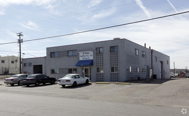

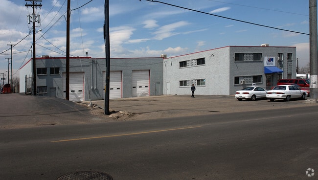

This Property Is For Sale
Current Lease Availabilities
NEARBY LISTINGS FOR SALE OR LEASE
Property Detail
5151 York St
2144-00-099
T3 R68 S14 SE/4 NE/4 BEG E/4 COR SD SE/4 S 527FT TO TPOB W 292.14FT N 320.46FT S 80DEG0M 58SEC E 293.40FT S 269.60FT TO TPOB
Warehouse
Denver
X
Colorado
0800460087H
1.98 AC
2024
Upper North Central
2024
Denver
003501
Denver-Aurora-Lakewood, CO
12,387 SF
DEMOGRAPHICS near 5151 York St
1 Mile
3 Mile
5 Mile
2024 Total Population
4,863
85,189
389,149
2029 Population
4,892
86,786
397,778
Pop Growth 2024-2029
+ 0.60%
+ 1.87%
+ 2.22%
Average Age
35
36
37
2024 Total Households
1,414
35,423
176,353
HH Growth 2024-2029
+ 0.42%
+ 1.86%
+ 2.12%
Median Household Inc
$51,860
$81,014
$84,902
Avg Household Size
3.10
2.20
2.10
2024 Avg HH Vehicles
2.00
2.00
2.00
Median Home Value
$331,456
$534,749
$584,766
Median Year Built
1951
1965
1970
Nearby Places
Map Layers
Map Styles
 Street
 Aerial
- Restaurants
- Banks
- Shops
- Fitness
- Groceries
PUBLIC TRANSPORTATION
COMMUTER RAIL
48Th & Brighton-National Western Station Track 1 (Union Station to Eastlake & 124th Station - Regional Transportation District)
DRIVE
WALK
Distance
48Th & Brighton-National Western Station Track 1 (Union Station to Eastlake & 124th Station - Regional Transportation District)
3 min
15 min
0.8 mi
40Th & Colorado Station Track 2 (Union Station to Denver Airport Station - Regional Transportation District)
DRIVE
WALK
Distance
40Th & Colorado Station Track 2 (Union Station to Denver Airport Station - Regional Transportation District)
5 min
1.9 mi
AIRPORT
Denver International
DRIVE
WALK
Distance
Denver International
28 min
21.2 mi
Freight Ports
Tulsa Port Of Catoosa
DRIVE
WALK
Distance
Tulsa Port Of Catoosa
725 min
706.7 mi
Nearby Properties
Address
Land Use
TOTAL SIZE
Lot Size
Zoning
Address
Land Use
TOTAL SIZE
Lot Size
Zoning
396,741 SF
8.12 AC
A1
Address
Land Use
TOTAL SIZE
Lot Size
Zoning
934,630 SF
10.93 AC
H-1-A
Address
Land Use
TOTAL SIZE
Lot Size
Zoning
281,209 SF
1.66 AC
C-MX-12
Address
Land Use
TOTAL SIZE
Lot Size
Zoning
25,000 SF
40.42 AC
I-A
Address
Land Use
TOTAL SIZE
Lot Size
Zoning
3,188 SF
81.17 AC
I-B
Address
Land Use
TOTAL SIZE
Lot Size
Zoning
230,246 SF
0.79 AC
I-MX-8
Address
Land Use
TOTAL SIZE
Lot Size
Zoning
237,753 SF
18.94 AC
U-SU-B1
Address
Land Use
TOTAL SIZE
Lot Size
Zoning
649,540 SF
33.65 AC
Address
Land Use
TOTAL SIZE
Lot Size
Zoning
238,888 SF
1.13 AC
C-MX-12
Address
Land Use
TOTAL SIZE
Lot Size
Zoning
177,366 SF
3.85 AC
C-MX-8
Address
Land Use
TOTAL SIZE
Lot Size
Zoning
551,915 SF
25.76 AC
Address
Land Use
TOTAL SIZE
Lot Size
Zoning
201,798 SF
0.71 AC
I-MX-5
Address
Land Use
TOTAL SIZE
Lot Size
Zoning
359,819 SF
7.23 AC
CMP-H
Address
Land Use
TOTAL SIZE
Lot Size
Zoning
599,680 SF
43.94 AC
Address
Land Use
TOTAL SIZE
Lot Size
Zoning
172,690 SF
0.62 AC
C-MX-12
Address
Land Use
TOTAL SIZE
Lot Size
Zoning
470,539 SF
23.59 AC
Address
Land Use
TOTAL SIZE
Lot Size
Zoning
176,795 SF
0.81 AC
I-MX-12
Address
Land Use
TOTAL SIZE
Lot Size
Zoning
352,600 SF
18.21 AC
I-B
Address
Land Use
TOTAL SIZE
Lot Size
Zoning
552,279 SF
2.22 AC
C-RX
Address
Land Use
TOTAL SIZE
Lot Size
Zoning
419,745 SF
24.75 AC
Address
Land Use
TOTAL SIZE
Lot Size
Zoning
140,437 SF
1.76 AC
C-MX
Address
Land Use
TOTAL SIZE
Lot Size
Zoning
727,307 SF
38.44 AC
I-B
Address
Land Use
TOTAL SIZE
Lot Size
Zoning
390,764 SF
20.19 AC
Address
Land Use
TOTAL SIZE
Lot Size
Zoning
595,017 SF
11.62 AC
I-B
Address
Land Use
TOTAL SIZE
Lot Size
Zoning
344,689 SF
11.77 AC
I-B
Address
Land Use
TOTAL SIZE
Lot Size
Zoning
228,564 SF
11.07 AC
U-SU-A1
Address
Land Use
TOTAL SIZE
Lot Size
Zoning
325,826 SF
73.92 AC
OS-A
Address
Land Use
TOTAL SIZE
Lot Size
Zoning
343,090 SF
11.75 AC
C-RX-12
Address
Land Use
TOTAL SIZE
Lot Size
Zoning
3.42 AC
C-MX-12
Address
Land Use
TOTAL SIZE
Lot Size
Zoning
657,947 SF
5.02 AC
C-RX
The World's #1 Commercial Real Estate Marketplace
Connect with us
© 2025 CoStar Group
The information above has been obtained from sources believed reliable. While we do not doubt its accuracy we have not verified it and make no guarantee, warranty or representation about it. It is your responsibility to independently confirm its accuracy and completeness. Any projections, opinions, assumptions, or estimates used are for example only and do not represent the current or future performance of the property. The value of this transaction to you depends on tax and other factors which should be evaluated by your tax, financial, and legal advisors. You and your advisors should conduct a careful, independent investigation of the property to determine to your satisfaction the suitability of the property for your needs.