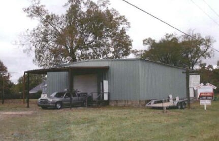
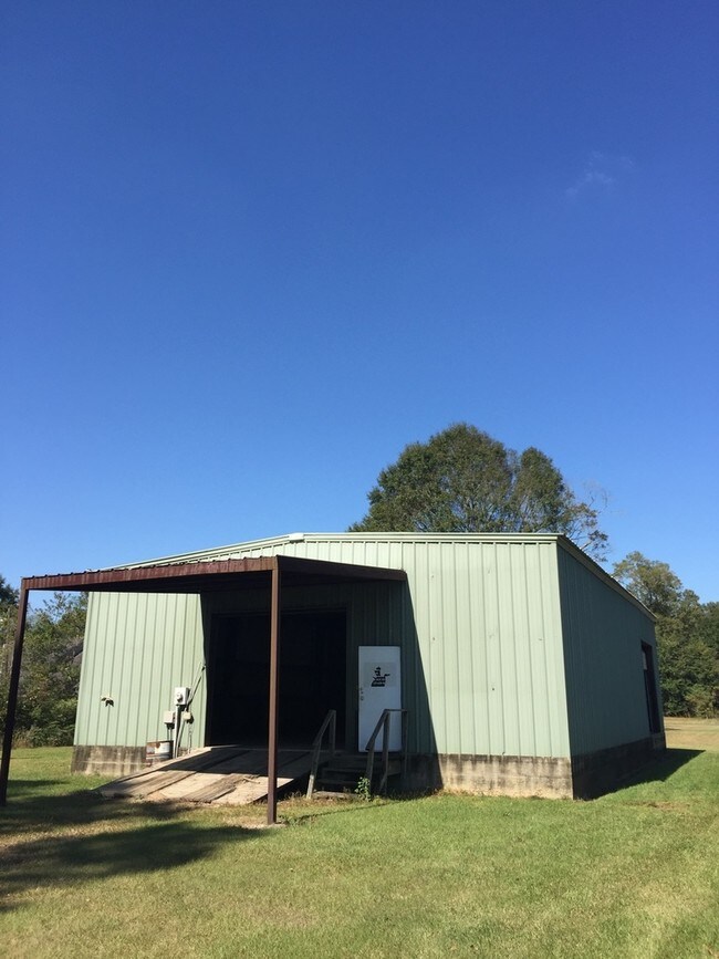
Property Record
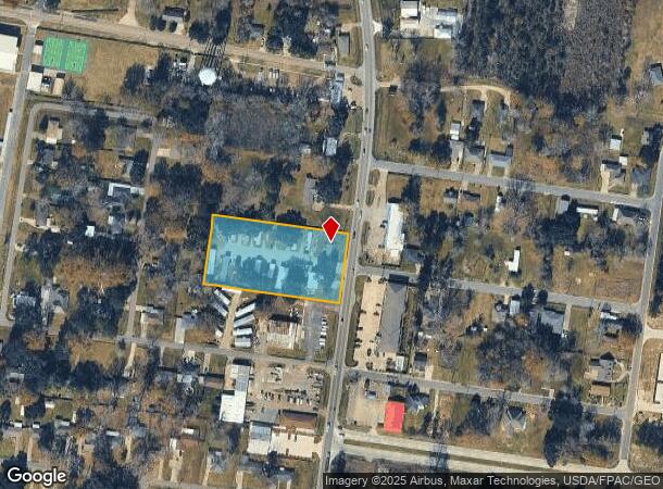
5157 Highway 19 Hwy, Zachary, LA 70791
NEARBY LISTINGS FOR SALE OR LEASE
Property Detail
5157 Highway 19 Hwy
Baton Rouge, LA
Paine Tract
01594648
WARD: 2-3, SUBDIVISION: PAINE TRACT, LOT: 2, BLOCK: 82. 2.00 ACRES BEING SITUATED ON THE W SIDE OF THE NEW ZACHARY-SLAUGHTER HWY STATE RT 19, IN SEC 53, T4S R1E
Storesoffices
E Baton Rouge
X
Louisiana
22033C0045F
2
2024
2 AC
2024
East Baton Rouge Parish North
0046022033
Baton Rouge
1,910 SF
DEMOGRAPHICS near 5157 Highway 19 Hwy
1 Mile
3 Mile
5 Mile
2024 Total Population
3,709
18,251
33,703
2029 Population
3,652
17,835
33,076
Pop Growth 2024-2029
(1.54%)
(2.28%)
(1.86%)
Average Age
40
37
38
2024 Total Households
1,443
6,518
12,196
HH Growth 2024-2029
(1.52%)
(2.26%)
(1.88%)
Median Household Inc
$59,963
$76,474
$65,690
Avg Household Size
2.50
2.80
2.70
2024 Avg HH Vehicles
2.00
2.00
2.00
Median Home Value
$201,160
$247,127
$229,658
Median Year Built
1986
1998
1993
Nearby Places
Map Layers
Map Styles
 Street
 Aerial
- Restaurants
- Banks
- Shops
- Fitness
- Groceries
PUBLIC TRANSPORTATION
AIRPORT
Baton Rouge Metro Ryan Field
DRIVE
WALK
Distance
Baton Rouge Metro Ryan Field
17 min
11.0 mi
Freight Ports
Port of Greater Baton Rouge
DRIVE
WALK
Distance
Port of Greater Baton Rouge
31 min
19.8 mi
SALE & LEASE HISTORY
LISTING DATE
SALE/LEASE

Sep 14, 2017
For Sale
Nov 14, 2016
For Sale
Nearby Properties
Address
Land Use
TOTAL SIZE
Lot Size
Zoning
Address
Land Use
TOTAL SIZE
Lot Size
Zoning
22.22 AC
Address
Land Use
TOTAL SIZE
Lot Size
Zoning
111,912 SF
28.33 AC
Address
Land Use
TOTAL SIZE
Lot Size
Zoning
15.41 AC
Address
Land Use
TOTAL SIZE
Lot Size
Zoning
Address
Land Use
TOTAL SIZE
Lot Size
Zoning
102,720 SF
10 AC
Address
Land Use
TOTAL SIZE
Lot Size
Zoning
82,615 SF
15.71 AC
Address
Land Use
TOTAL SIZE
Lot Size
Zoning
156,100 SF
16.32 AC
Address
Land Use
TOTAL SIZE
Lot Size
Zoning
9,994 SF
11.40 AC
Address
Land Use
TOTAL SIZE
Lot Size
Zoning
61,274 SF
2.91 AC
Address
Land Use
TOTAL SIZE
Lot Size
Zoning
102,513 SF
14.22 AC
Address
Land Use
TOTAL SIZE
Lot Size
Zoning
5.84 AC
Address
Land Use
TOTAL SIZE
Lot Size
Zoning
17,537 SF
20 AC
Address
Land Use
TOTAL SIZE
Lot Size
Zoning
47,750 SF
5.89 AC
Address
Land Use
TOTAL SIZE
Lot Size
Zoning
52,600 SF
11.31 AC
Address
Land Use
TOTAL SIZE
Lot Size
Zoning
2,668 SF
2.46 AC
Address
Land Use
TOTAL SIZE
Lot Size
Zoning
28,800 SF
3.26 AC
Address
Land Use
TOTAL SIZE
Lot Size
Zoning
Address
Land Use
TOTAL SIZE
Lot Size
Zoning
9,012 SF
2.72 AC
Address
Land Use
TOTAL SIZE
Lot Size
Zoning
Address
Land Use
TOTAL SIZE
Lot Size
Zoning
24,450 SF
2.26 AC
Address
Land Use
TOTAL SIZE
Lot Size
Zoning
35,982 SF
12.58 AC
Address
Land Use
TOTAL SIZE
Lot Size
Zoning
Address
Land Use
TOTAL SIZE
Lot Size
Zoning
99,786 SF
0.17 AC
Address
Land Use
TOTAL SIZE
Lot Size
Zoning
Address
Land Use
TOTAL SIZE
Lot Size
Zoning
40,188 SF
16.58 AC
Address
Land Use
TOTAL SIZE
Lot Size
Zoning
61,894 SF
1.50 AC
Address
Land Use
TOTAL SIZE
Lot Size
Zoning
Address
Land Use
TOTAL SIZE
Lot Size
Zoning
13,645 SF
3.38 AC
Address
Land Use
TOTAL SIZE
Lot Size
Zoning
1.24 AC
Address
Land Use
TOTAL SIZE
Lot Size
Zoning
35,751 SF
13.36 AC
The World's #1 Commercial Real Estate Marketplace
Connect with us
© 2025 CoStar Group
The information above has been obtained from sources believed reliable. While we do not doubt its accuracy we have not verified it and make no guarantee, warranty or representation about it. It is your responsibility to independently confirm its accuracy and completeness. Any projections, opinions, assumptions, or estimates used are for example only and do not represent the current or future performance of the property. The value of this transaction to you depends on tax and other factors which should be evaluated by your tax, financial, and legal advisors. You and your advisors should conduct a careful, independent investigation of the property to determine to your satisfaction the suitability of the property for your needs.