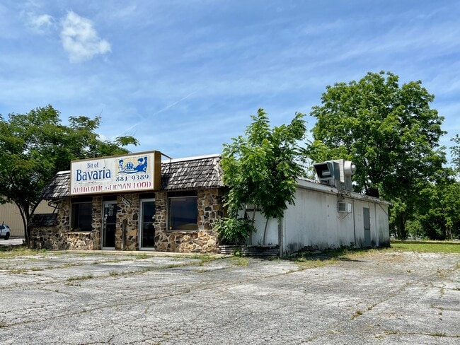
Property Record
5159 S Campbell Ave, Springfield, MO 65810

Property Detail
5159 S Campbell Ave
18-23-100-090
1.5 AC M/L BEG 30 FT W & 230 FT N OF SE COR NE4 NE4 N100FT W630FT S100FT E TO POB 23/28N/22/W
Restaurantbuilding
Greene
INC
Missouri
B and X Area of moderate flood hazard, usually the area between the limits of the 100-year and 500-year floods.
1.50 AC
2025
Southwest
2025
Springfield
004109
Springfield, MO
NEARBY LISTINGS FOR SALE OR LEASE
DEMOGRAPHICS near 5159 S Campbell Ave
1 mile
3 mile
5 mile
2025 Total Population
8,066
53,253
130,621
2030 Population
8,223
54,429
134,152
Pop Growth 2025-2030
+ 1.95%
+ 2.21%
+ 2.70%
Average Age
41
41
41
2025 Total Households
3,471
23,847
57,224
HH Growth 2025-2030
+ 2.05%
+ 2.24%
+ 2.74%
Median Household Inc
$83,621
$66,202
$66,752
Avg Household Size
2.30
2.20
2.20
2025 Avg HH Vehicles
2.00
2.00
2.00
Median Home Value
$314,014
$275,748
$267,056
Median Year Built
1995
1990
1988
Nearby Places
Map Layers
Map Styles
 Street
 Aerial
Transit
 Traffic
 Biking
Places
Listings with unknown addresses are not visible on the map
- Restaurants
- Banks
- Shops
- Fitness
- Groceries
PUBLIC TRANSPORTATION
AIRPORT
Springfield-Branson Ntl
Drive
Walk
Distance
Springfield-Branson Ntl
33 min
15.9 mi
SALE & LEASE HISTORY
LISTING DATE
SALE/LEASE

Jun 10, 2022
For Lease
Nearby Properties
Address
Land Use
TOTAL SIZE
Lot Size
Zoning
Address
Land Use
TOTAL SIZE
Lot Size
Zoning
18.52 AC
INC
Address
Land Use
TOTAL SIZE
Lot Size
Zoning
15.46 AC
Address
Land Use
TOTAL SIZE
Lot Size
Zoning
284,904 SF
24.38 AC
INC
Address
Land Use
TOTAL SIZE
Lot Size
Zoning
376,072 SF
17.67 AC
INC
Address
Land Use
TOTAL SIZE
Lot Size
Zoning
12.74 AC
Address
Land Use
TOTAL SIZE
Lot Size
Zoning
180,665 SF
6.36 AC
INC
Address
Land Use
TOTAL SIZE
Lot Size
Zoning
15.46 AC
INC.
Address
Land Use
TOTAL SIZE
Lot Size
Zoning
1.98 AC
INC.
Address
Land Use
TOTAL SIZE
Lot Size
Zoning
105,278 SF
0.54 AC
INC
Address
Land Use
TOTAL SIZE
Lot Size
Zoning
2.31 AC
INC
Address
Land Use
TOTAL SIZE
Lot Size
Zoning
108,880 SF
3.62 AC
INC
Address
Land Use
TOTAL SIZE
Lot Size
Zoning
312,092 SF
38 AC
INC
Address
Land Use
TOTAL SIZE
Lot Size
Zoning
2.76 AC
INC.
Address
Land Use
TOTAL SIZE
Lot Size
Zoning
26.03 AC
INC
Address
Land Use
TOTAL SIZE
Lot Size
Zoning
11.56 AC
INC
Address
Land Use
TOTAL SIZE
Lot Size
Zoning
3.43 AC
INC
Address
Land Use
TOTAL SIZE
Lot Size
Zoning
9.82 AC
INC
Address
Land Use
TOTAL SIZE
Lot Size
Zoning
8.24 AC
INC
Address
Land Use
TOTAL SIZE
Lot Size
Zoning
140,147 SF
17.64 AC
INC
Address
Land Use
TOTAL SIZE
Lot Size
Zoning
42,540 SF
3.63 AC
INC
Address
Land Use
TOTAL SIZE
Lot Size
Zoning
30,400 SF
9.05 AC
INC
Address
Land Use
TOTAL SIZE
Lot Size
Zoning
12.90 AC
INC
Address
Land Use
TOTAL SIZE
Lot Size
Zoning
6.50 AC
INC.
Address
Land Use
TOTAL SIZE
Lot Size
Zoning
27.78 AC
INC
Address
Land Use
TOTAL SIZE
Lot Size
Zoning
86,566 SF
9.63 AC
INC
Address
Land Use
TOTAL SIZE
Lot Size
Zoning
6.24 AC
INC
Address
Land Use
TOTAL SIZE
Lot Size
Zoning
Address
Land Use
TOTAL SIZE
Lot Size
Zoning
89,310 SF
10.89 AC
INC
Address
Land Use
TOTAL SIZE
Lot Size
Zoning
117,322 SF
12.67 AC
INC
Address
Land Use
TOTAL SIZE
Lot Size
Zoning
47,214 SF
4.25 AC
INC
The World's #1 Commercial Real Estate Marketplace
Connect with us
© 2026 CoStar Group
The information above has been obtained from sources believed reliable. While we do not doubt its accuracy we have not verified it and make no guarantee, warranty or representation about it. It is your responsibility to independently confirm its accuracy and completeness. Any projections, opinions, assumptions, or estimates used are for example only and do not represent the current or future performance of the property. The value of this transaction to you depends on tax and other factors which should be evaluated by your tax, financial, and legal advisors. You and your advisors should conduct a careful, independent investigation of the property to determine to your satisfaction the suitability of the property for your needs.