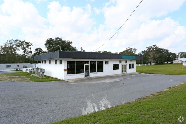
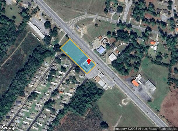
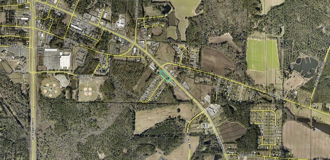
Property Record
Ga Highway 133 S, Moultrie, GA 31788
NEARBY LISTINGS FOR SALE OR LEASE
Property Detail
Ga Highway 133 S
M008-090
LL 294 8TH LD REGENCY VILLAGE
Storebuilding
Colquitt
X
Georgia
13275C0100E
1.40 AC
2025
Albany/Southwest
2024
Other Market Areas
970703
Moultrie, GA
2,400 SF
DEMOGRAPHICS near Ga Highway 133 S
1 Mile
3 Mile
5 Mile
2024 Total Population
1,602
13,884
26,737
2029 Population
1,595
13,950
26,823
Pop Growth 2024-2029
(0.44%)
+ 0.48%
+ 0.32%
Average Age
38
39
38
2024 Total Households
620
5,281
10,072
HH Growth 2024-2029
(0.65%)
+ 0.40%
+ 0.32%
Median Household Inc
$31,875
$36,336
$38,881
Avg Household Size
2.40
2.50
2.50
2024 Avg HH Vehicles
1.00
2.00
2.00
Median Home Value
$84,883
$98,037
$119,957
Median Year Built
1990
1977
1980
Nearby Places
Map Layers
Map Styles
 Street
 Aerial
- Restaurants
- Banks
- Shops
- Fitness
- Groceries
SALE & LEASE HISTORY
LISTING DATE
SALE/LEASE

Apr 16, 2024
For Sale
Nearby Properties
Address
Land Use
TOTAL SIZE
Lot Size
Zoning
Address
Land Use
TOTAL SIZE
Lot Size
Zoning
200,104 SF
186.32 AC
Address
Land Use
TOTAL SIZE
Lot Size
Zoning
38,268 SF
2.07 AC
Address
Land Use
TOTAL SIZE
Lot Size
Zoning
73.72 AC
Address
Land Use
TOTAL SIZE
Lot Size
Zoning
24.25 AC
Address
Land Use
TOTAL SIZE
Lot Size
Zoning
21,678 SF
5.75 AC
Address
Land Use
TOTAL SIZE
Lot Size
Zoning
115.93 AC
COMMERCIAL
Address
Land Use
TOTAL SIZE
Lot Size
Zoning
21,866 SF
1.44 AC
Address
Land Use
TOTAL SIZE
Lot Size
Zoning
11.45 AC
Address
Land Use
TOTAL SIZE
Lot Size
Zoning
2,606 SF
15 AC
Address
Land Use
TOTAL SIZE
Lot Size
Zoning
17,574 SF
1.59 AC
Address
Land Use
TOTAL SIZE
Lot Size
Zoning
149,407 SF
15.29 AC
Address
Land Use
TOTAL SIZE
Lot Size
Zoning
27,504 SF
1.98 AC
Address
Land Use
TOTAL SIZE
Lot Size
Zoning
64,000 SF
13.98 AC
Address
Land Use
TOTAL SIZE
Lot Size
Zoning
18,096 SF
12.13 AC
Address
Land Use
TOTAL SIZE
Lot Size
Zoning
111,860 SF
13.50 AC
002
Address
Land Use
TOTAL SIZE
Lot Size
Zoning
105,612 SF
13.19 AC
002
Address
Land Use
TOTAL SIZE
Lot Size
Zoning
61,200 SF
9.50 AC
Address
Land Use
TOTAL SIZE
Lot Size
Zoning
189,470 SF
12.68 AC
Address
Land Use
TOTAL SIZE
Lot Size
Zoning
48,965 SF
5.24 AC
Address
Land Use
TOTAL SIZE
Lot Size
Zoning
27,217 SF
20.32 AC
Address
Land Use
TOTAL SIZE
Lot Size
Zoning
9,916 SF
6.24 AC
002
Address
Land Use
TOTAL SIZE
Lot Size
Zoning
96,140 SF
1,154.48 AC
Address
Land Use
TOTAL SIZE
Lot Size
Zoning
21,574 SF
1.11 AC
Address
Land Use
TOTAL SIZE
Lot Size
Zoning
41,170 SF
1.63 AC
Address
Land Use
TOTAL SIZE
Lot Size
Zoning
37,295 SF
8.30 AC
Address
Land Use
TOTAL SIZE
Lot Size
Zoning
841 SF
8.15 AC
Address
Land Use
TOTAL SIZE
Lot Size
Zoning
1,070 SF
6.07 AC
Address
Land Use
TOTAL SIZE
Lot Size
Zoning
38,848 SF
0.52 AC
Address
Land Use
TOTAL SIZE
Lot Size
Zoning
36,355 SF
7.08 AC
Address
Land Use
TOTAL SIZE
Lot Size
Zoning
16.27 AC
The World's #1 Commercial Real Estate Marketplace
Connect with us
© 2025 CoStar Group
The information above has been obtained from sources believed reliable. While we do not doubt its accuracy we have not verified it and make no guarantee, warranty or representation about it. It is your responsibility to independently confirm its accuracy and completeness. Any projections, opinions, assumptions, or estimates used are for example only and do not represent the current or future performance of the property. The value of this transaction to you depends on tax and other factors which should be evaluated by your tax, financial, and legal advisors. You and your advisors should conduct a careful, independent investigation of the property to determine to your satisfaction the suitability of the property for your needs.