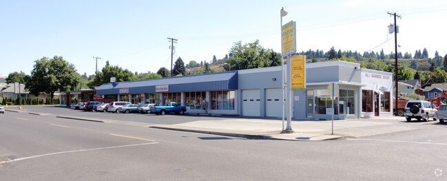
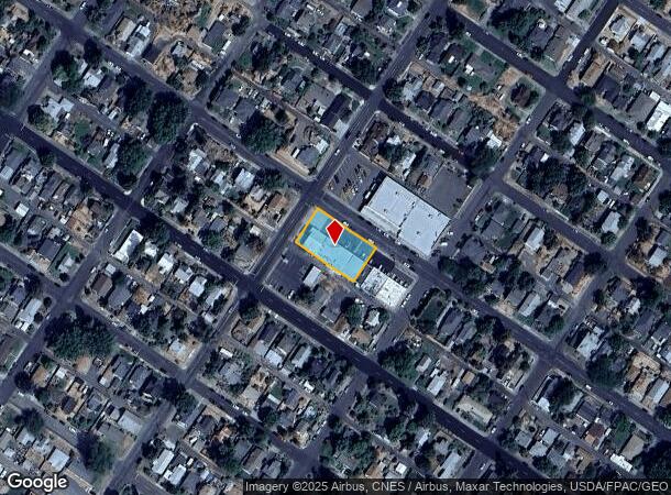
Property Record
516 W 9Th St, The Dalles, OR 97058
NEARBY LISTINGS FOR SALE OR LEASE
Property Detail
516 W 9Th St
The Dalles, OR
SECTION 4 TOWNSHIP 1N RANGE 13E QUARTER AD PRCL 12000 MAPTAX LOT: 01N13 E04AD12000 00
5216
Wasco
Commercialnec
Oregon
2025
0.40 AC
2025
Oregon East Area
970400
Other Market Areas
DEMOGRAPHICS near 516 W 9Th St
1 Mile
3 Mile
5 Mile
2024 Total Population
7,250
18,625
20,661
2029 Population
7,187
18,506
20,548
Pop Growth 2024-2029
(0.87%)
(0.64%)
(0.55%)
Average Age
40
41
41
2024 Total Households
2,777
7,208
8,018
HH Growth 2024-2029
(0.97%)
(0.75%)
(0.66%)
Median Household Inc
$56,554
$58,751
$59,043
Avg Household Size
2.50
2.50
2.50
2024 Avg HH Vehicles
2.00
2.00
2.00
Median Home Value
$290,179
$300,670
$311,975
Median Year Built
1952
1968
1970
Nearby Places
Map Layers
Map Styles
 Street
 Aerial
- Restaurants
- Banks
- Shops
- Fitness
- Groceries
Nearby Properties
Address
Land Use
TOTAL SIZE
Lot Size
Zoning
Address
Land Use
TOTAL SIZE
Lot Size
Zoning
Address
Land Use
TOTAL SIZE
Lot Size
Zoning
Address
Land Use
TOTAL SIZE
Lot Size
Zoning
26.33 AC
Address
Land Use
TOTAL SIZE
Lot Size
Zoning
Address
Land Use
TOTAL SIZE
Lot Size
Zoning
Address
Land Use
TOTAL SIZE
Lot Size
Zoning
Address
Land Use
TOTAL SIZE
Lot Size
Zoning
Address
Land Use
TOTAL SIZE
Lot Size
Zoning
Address
Land Use
TOTAL SIZE
Lot Size
Zoning
Address
Land Use
TOTAL SIZE
Lot Size
Zoning
30.74 AC
I INDUSTRI
Address
Land Use
TOTAL SIZE
Lot Size
Zoning
5.52 AC
CG GENERAL
Address
Land Use
TOTAL SIZE
Lot Size
Zoning
3.01 AC
CR RECREAT
Address
Land Use
TOTAL SIZE
Lot Size
Zoning
12.37 AC
RL
Address
Land Use
TOTAL SIZE
Lot Size
Zoning
Address
Land Use
TOTAL SIZE
Lot Size
Zoning
Address
Land Use
TOTAL SIZE
Lot Size
Zoning
9.38 AC
CG GENERAL
Address
Land Use
TOTAL SIZE
Lot Size
Zoning
3.69 AC
RH HIGH/ME
Address
Land Use
TOTAL SIZE
Lot Size
Zoning
Address
Land Use
TOTAL SIZE
Lot Size
Zoning
Address
Land Use
TOTAL SIZE
Lot Size
Zoning
2.10 AC
CG
Address
Land Use
TOTAL SIZE
Lot Size
Zoning
3.74 AC
NC NBRHD C
Address
Land Use
TOTAL SIZE
Lot Size
Zoning
3.49 AC
CG GENERAL
Address
Land Use
TOTAL SIZE
Lot Size
Zoning
4.13 AC
CG GENERAL
Address
Land Use
TOTAL SIZE
Lot Size
Zoning
Address
Land Use
TOTAL SIZE
Lot Size
Zoning
1.20 AC
Address
Land Use
TOTAL SIZE
Lot Size
Zoning
Address
Land Use
TOTAL SIZE
Lot Size
Zoning
4.28 AC
CG GENERAL
Address
Land Use
TOTAL SIZE
Lot Size
Zoning
7.78 AC
CG
Address
Land Use
TOTAL SIZE
Lot Size
Zoning
4.23 AC
Address
Land Use
TOTAL SIZE
Lot Size
Zoning
82.43 AC
I
The World's #1 Commercial Real Estate Marketplace
Connect with us
© 2025 CoStar Group
The information above has been obtained from sources believed reliable. While we do not doubt its accuracy we have not verified it and make no guarantee, warranty or representation about it. It is your responsibility to independently confirm its accuracy and completeness. Any projections, opinions, assumptions, or estimates used are for example only and do not represent the current or future performance of the property. The value of this transaction to you depends on tax and other factors which should be evaluated by your tax, financial, and legal advisors. You and your advisors should conduct a careful, independent investigation of the property to determine to your satisfaction the suitability of the property for your needs.