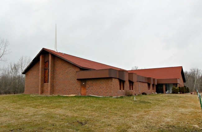
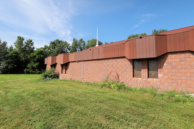
Property Record
5165 M L King Ave, Flint, MI 48505
NEARBY LISTINGS FOR SALE OR LEASE
-
-
View all Flint listings for sale on LoopNet.com
Property Detail
5165 M L King Ave
14-24-300-004
A PARCEL OF LAND BEG AT NE COR OF LOT 1031 OF CRESTLINE TH N 87 DEG 34 MIN 20 SEC W 807.42 FT TH N 02 DEG 12 MIN 36 SEC E
Commercialnec
Genesee
X
Michigan
26049C0179D
1031
2024
Flint
2025
Detroit
000400
Flint, MI
DEMOGRAPHICS near 5165 M L King Ave
1 Mile
3 Mile
5 Mile
2024 Total Population
9,479
48,877
113,391
2029 Population
9,784
50,384
115,321
Pop Growth 2024-2029
+ 3.22%
+ 3.08%
+ 1.70%
Average Age
39
39
40
2024 Total Households
3,768
20,086
47,034
HH Growth 2024-2029
+ 3.37%
+ 3.20%
+ 1.68%
Median Household Inc
$30,755
$32,862
$36,464
Avg Household Size
2.40
2.30
2.30
2024 Avg HH Vehicles
1.00
1.00
1.00
Median Home Value
$55,883
$61,354
$72,206
Median Year Built
1961
1961
1960
Nearby Places
Map Layers
Map Styles
 Street
 Aerial
- Restaurants
- Banks
- Shops
- Fitness
- Groceries
PUBLIC TRANSPORTATION
COMMUTER RAIL
DRIVE
WALK
Distance
13 min
6.6 mi
AIRPORT
Bishop International
DRIVE
WALK
Distance
Bishop International
28 min
14.5 mi
MBS International
DRIVE
WALK
Distance
MBS International
62 min
47.1 mi
SALE & LEASE HISTORY
LISTING DATE
SALE/LEASE

Jul 17, 2019
For Sale
Nearby Properties
Address
Land Use
TOTAL SIZE
Lot Size
Zoning
Address
Land Use
TOTAL SIZE
Lot Size
Zoning
46,808 SF
32.06 AC
I-2 HVY IN
Address
Land Use
TOTAL SIZE
Lot Size
Zoning
114,888 SF
11.86 AC
I-2 HVY IN
Address
Land Use
TOTAL SIZE
Lot Size
Zoning
182,408 SF
Address
Land Use
TOTAL SIZE
Lot Size
Zoning
Address
Land Use
TOTAL SIZE
Lot Size
Zoning
Address
Land Use
TOTAL SIZE
Lot Size
Zoning
224,263 SF
24.98 AC
CC
Address
Land Use
TOTAL SIZE
Lot Size
Zoning
173,312 SF
23.49 AC
CE
Address
Land Use
TOTAL SIZE
Lot Size
Zoning
101,744 SF
4.90 AC
TN-2
Address
Land Use
TOTAL SIZE
Lot Size
Zoning
33.39 AC
Address
Land Use
TOTAL SIZE
Lot Size
Zoning
94,719 SF
7.55 AC
R-1 SF PUD
Address
Land Use
TOTAL SIZE
Lot Size
Zoning
Address
Land Use
TOTAL SIZE
Lot Size
Zoning
7.33 AC
Address
Land Use
TOTAL SIZE
Lot Size
Zoning
2.45 AC
Address
Land Use
TOTAL SIZE
Lot Size
Zoning
52,434 SF
4.09 AC
CE
Address
Land Use
TOTAL SIZE
Lot Size
Zoning
9,934 SF
9.70 AC
I-2 HVY IN
Address
Land Use
TOTAL SIZE
Lot Size
Zoning
76,051 SF
8.31 AC
C-2 HWY CO
Address
Land Use
TOTAL SIZE
Lot Size
Zoning
80,999 SF
23.82 AC
CE
Address
Land Use
TOTAL SIZE
Lot Size
Zoning
19.75 AC
Address
Land Use
TOTAL SIZE
Lot Size
Zoning
123,690 SF
9.73 AC
PC
Address
Land Use
TOTAL SIZE
Lot Size
Zoning
3,434 SF
5.63 AC
I-1 LHGT I
Address
Land Use
TOTAL SIZE
Lot Size
Zoning
Address
Land Use
TOTAL SIZE
Lot Size
Zoning
Address
Land Use
TOTAL SIZE
Lot Size
Zoning
10.15 AC
Address
Land Use
TOTAL SIZE
Lot Size
Zoning
49,798 SF
4.22 AC
CC
Address
Land Use
TOTAL SIZE
Lot Size
Zoning
20.06 AC
Address
Land Use
TOTAL SIZE
Lot Size
Zoning
86,786 SF
9.41 AC
CE
Address
Land Use
TOTAL SIZE
Lot Size
Zoning
31.55 AC
Address
Land Use
TOTAL SIZE
Lot Size
Zoning
47.29 AC
Address
Land Use
TOTAL SIZE
Lot Size
Zoning
50,760 SF
5.99 AC
GI-1
Address
Land Use
TOTAL SIZE
Lot Size
Zoning
2.31 AC
The World's #1 Commercial Real Estate Marketplace
Connect with us
© 2025 CoStar Group
The information above has been obtained from sources believed reliable. While we do not doubt its accuracy we have not verified it and make no guarantee, warranty or representation about it. It is your responsibility to independently confirm its accuracy and completeness. Any projections, opinions, assumptions, or estimates used are for example only and do not represent the current or future performance of the property. The value of this transaction to you depends on tax and other factors which should be evaluated by your tax, financial, and legal advisors. You and your advisors should conduct a careful, independent investigation of the property to determine to your satisfaction the suitability of the property for your needs.