Property Record
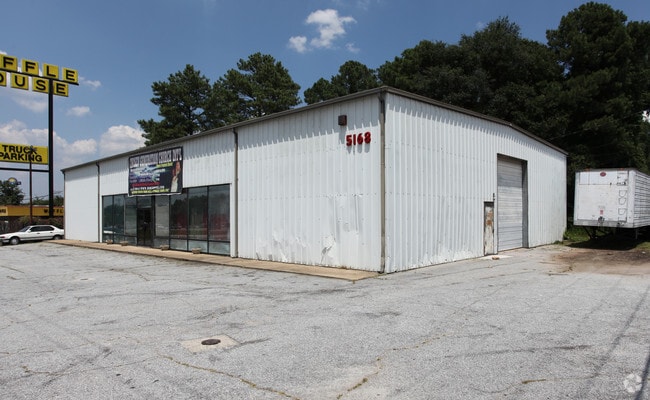
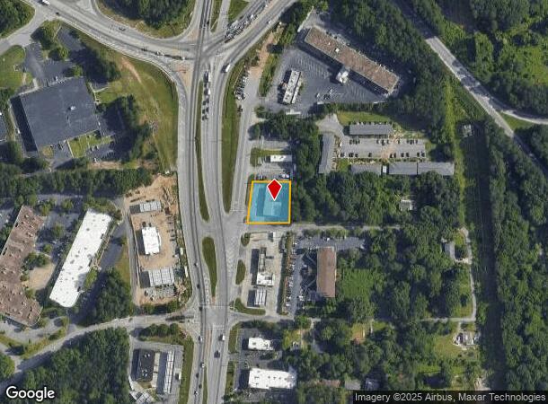
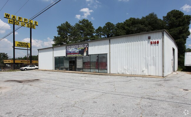
5168 Georgia Highway 85, Forest Park, GA 30297
NEARBY LISTINGS FOR SALE OR LEASE
Property Detail
5168 Georgia Highway 85
13-0075B-00B-003
Clayton
Warehouse
Georgia
X
3-4
13063C0057F
0.49 AC
2025
Airport/North Clayton
2025
Atlanta
040202
Atlanta-Sandy Springs-Roswell, GA
6,000 SF
DEMOGRAPHICS near 5168 Georgia Highway 85
1 Mile
3 Mile
5 Mile
2024 Total Population
769
59,937
178,076
2029 Population
753
59,654
180,287
Pop Growth 2024-2029
(2.08%)
(0.47%)
+ 1.24%
Average Age
36
34
36
2024 Total Households
445
23,097
66,706
HH Growth 2024-2029
(2.25%)
(0.50%)
+ 1.33%
Median Household Inc
$53,469
$41,238
$44,409
Avg Household Size
1.70
2.50
2.60
2024 Avg HH Vehicles
1.00
1.00
2.00
Median Home Value
$134,615
$136,216
$157,282
Median Year Built
1981
1978
1977
Nearby Places
Map Layers
Map Styles
 Street
 Aerial
- Restaurants
- Banks
- Shops
- Fitness
- Groceries
PUBLIC TRANSPORTATION
AIRPORT
Hartsfield - Jackson Atlanta International
DRIVE
WALK
Distance
Hartsfield - Jackson Atlanta International
8 min
3.5 mi
Freight Ports
Georgia Ports - Savannah
DRIVE
WALK
Distance
Georgia Ports - Savannah
266 min
239.1 mi
SALE & LEASE HISTORY
LISTING DATE
SALE/LEASE

Sep 17, 2021
For Sale
Nearby Properties
Address
Land Use
TOTAL SIZE
Lot Size
Zoning
Address
Land Use
TOTAL SIZE
Lot Size
Zoning
116,750 SF
997.24 AC
HI
Address
Land Use
TOTAL SIZE
Lot Size
Zoning
63,992 SF
174.80 AC
HI
Address
Land Use
TOTAL SIZE
Lot Size
Zoning
200,000 SF
34.20 AC
HI
Address
Land Use
TOTAL SIZE
Lot Size
Zoning
318.25 AC
HI
Address
Land Use
TOTAL SIZE
Lot Size
Zoning
518,648 SF
31.03 AC
MCD
Address
Land Use
TOTAL SIZE
Lot Size
Zoning
274.75 AC
HI
Address
Land Use
TOTAL SIZE
Lot Size
Zoning
28,000 SF
246.83 AC
I
Address
Land Use
TOTAL SIZE
Lot Size
Zoning
104.17 AC
C
Address
Land Use
TOTAL SIZE
Lot Size
Zoning
965,840 SF
1.50 AC
C
Address
Land Use
TOTAL SIZE
Lot Size
Zoning
229.84 AC
HI
Address
Land Use
TOTAL SIZE
Lot Size
Zoning
1,113,792 SF
3.68 AC
CR
Address
Land Use
TOTAL SIZE
Lot Size
Zoning
368,274 SF
171.85 AC
I1
Address
Land Use
TOTAL SIZE
Lot Size
Zoning
113,364 SF
2.19 AC
I
Address
Land Use
TOTAL SIZE
Lot Size
Zoning
115.30 AC
I
Address
Land Use
TOTAL SIZE
Lot Size
Zoning
596 SF
57.40 AC
RM
Address
Land Use
TOTAL SIZE
Lot Size
Zoning
699 SF
44.34 AC
RM
Address
Land Use
TOTAL SIZE
Lot Size
Zoning
105.66 AC
HI
Address
Land Use
TOTAL SIZE
Lot Size
Zoning
513,124 SF
19.05 AC
I2
Address
Land Use
TOTAL SIZE
Lot Size
Zoning
278,866 SF
7.59 AC
CR
Address
Land Use
TOTAL SIZE
Lot Size
Zoning
298,264 SF
0.90 AC
C
Address
Land Use
TOTAL SIZE
Lot Size
Zoning
352 SF
32.69 AC
RM
Address
Land Use
TOTAL SIZE
Lot Size
Zoning
370 SF
36.20 AC
RM
Address
Land Use
TOTAL SIZE
Lot Size
Zoning
264 SF
24.92 AC
RM
Address
Land Use
TOTAL SIZE
Lot Size
Zoning
212,048 SF
110.06 AC
HI
Address
Land Use
TOTAL SIZE
Lot Size
Zoning
387 SF
32.53 AC
RM
Address
Land Use
TOTAL SIZE
Lot Size
Zoning
96,028 SF
21.02 AC
I
Address
Land Use
TOTAL SIZE
Lot Size
Zoning
308,683 SF
41.30 AC
C
Address
Land Use
TOTAL SIZE
Lot Size
Zoning
216 SF
24.45 AC
RM
Address
Land Use
TOTAL SIZE
Lot Size
Zoning
200 SF
20.71 AC
RM
Address
Land Use
TOTAL SIZE
Lot Size
Zoning
298,674 SF
14.35 AC
I
The World's #1 Commercial Real Estate Marketplace
Connect with us
© 2025 CoStar Group
The information above has been obtained from sources believed reliable. While we do not doubt its accuracy we have not verified it and make no guarantee, warranty or representation about it. It is your responsibility to independently confirm its accuracy and completeness. Any projections, opinions, assumptions, or estimates used are for example only and do not represent the current or future performance of the property. The value of this transaction to you depends on tax and other factors which should be evaluated by your tax, financial, and legal advisors. You and your advisors should conduct a careful, independent investigation of the property to determine to your satisfaction the suitability of the property for your needs.