Property Record
517 28Th Ave N, Fargo, ND 58102
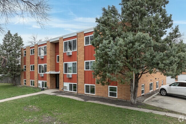

Property Detail
517 28Th Ave N
01-0720-00480-000
LOT: 31 BLOCK: 4 ADDITION: EDGEWOOD 1ST ADDITIONAL: EDGEWOOD 1ST LOTS 31 & 32 BLK 4 AND W 35' LOT 30
Apartment
Cass
MR2
North Dakota
C and X Area of minimal flood hazard, usually depicted on FIRMs as above the 500-year flood level.
30-32
2025
0.48 AC
2025
Northport
000203
Other Market Areas
10,908 SF
Fargo, ND-MN
NEARBY LISTINGS FOR SALE OR LEASE
DEMOGRAPHICS near 517 28Th Ave N
1 mile
3 mile
5 mile
2025 Total Population
13,043
45,829
107,231
2030 Population
13,902
48,753
113,564
Pop Growth 2025-2030
+ 6.59%
+ 6.38%
+ 5.91%
Average Age
39
37
37
2025 Total Households
5,639
20,581
47,102
HH Growth 2025-2030
+ 7.36%
+ 7.05%
+ 6.40%
Median Household Inc
$64,103
$56,163
$58,326
Avg Household Size
2.00
2.00
2.10
2025 Avg HH Vehicles
2.00
2.00
2.00
Median Home Value
$260,052
$242,355
$245,297
Median Year Built
1974
1971
1975
Nearby Places
Map Layers
Map Styles
 Street
 Aerial
Transit
 Traffic
 Biking
Places
Listings with unknown addresses are not visible on the map
- Restaurants
- Banks
- Shops
- Fitness
- Groceries
PUBLIC TRANSPORTATION
COMMUTER RAIL
Drive
Walk
Distance
6 min
2.4 mi
AIRPORT
Hector International
Drive
Walk
Distance
Hector International
5 min
1.7 mi
Nearby Properties
Address
Land Use
TOTAL SIZE
Lot Size
Zoning
Address
Land Use
TOTAL SIZE
Lot Size
Zoning
17.38 AC
Address
Land Use
TOTAL SIZE
Lot Size
Zoning
41.38 AC
Address
Land Use
TOTAL SIZE
Lot Size
Zoning
14.53 AC
Address
Land Use
TOTAL SIZE
Lot Size
Zoning
107,995 SF
1 AC
DMU
Address
Land Use
TOTAL SIZE
Lot Size
Zoning
12.07 AC
Address
Land Use
TOTAL SIZE
Lot Size
Zoning
5.23 AC
Address
Land Use
TOTAL SIZE
Lot Size
Zoning
3.31 AC
Address
Land Use
TOTAL SIZE
Lot Size
Zoning
0.17 AC
Address
Land Use
TOTAL SIZE
Lot Size
Zoning
303,970 SF
49.72 AC
GI
Address
Land Use
TOTAL SIZE
Lot Size
Zoning
73.98 AC
Address
Land Use
TOTAL SIZE
Lot Size
Zoning
109,174 SF
1.25 AC
UMU
Address
Land Use
TOTAL SIZE
Lot Size
Zoning
2.07 AC
Address
Land Use
TOTAL SIZE
Lot Size
Zoning
43,392 SF
1.02 AC
DMU
Address
Land Use
TOTAL SIZE
Lot Size
Zoning
1.60 AC
Address
Land Use
TOTAL SIZE
Lot Size
Zoning
71,811 SF
3.28 AC
GC
Address
Land Use
TOTAL SIZE
Lot Size
Zoning
10.87 AC
Address
Land Use
TOTAL SIZE
Lot Size
Zoning
Address
Land Use
TOTAL SIZE
Lot Size
Zoning
6.84 AC
Address
Land Use
TOTAL SIZE
Lot Size
Zoning
0.50 AC
Address
Land Use
TOTAL SIZE
Lot Size
Zoning
242,032 SF
14.23 AC
GI
Address
Land Use
TOTAL SIZE
Lot Size
Zoning
17,309 SF
0.23 AC
DMU
Address
Land Use
TOTAL SIZE
Lot Size
Zoning
106,250 SF
1.25 AC
DMU
Address
Land Use
TOTAL SIZE
Lot Size
Zoning
247,888 SF
15.13 AC
GI
Address
Land Use
TOTAL SIZE
Lot Size
Zoning
286,296 SF
18.30 AC
LI
Address
Land Use
TOTAL SIZE
Lot Size
Zoning
61,159 SF
0.96 AC
DMU
Address
Land Use
TOTAL SIZE
Lot Size
Zoning
2.26 AC
Address
Land Use
TOTAL SIZE
Lot Size
Zoning
1.95 AC
DMU
Address
Land Use
TOTAL SIZE
Lot Size
Zoning
0.95 AC
Address
Land Use
TOTAL SIZE
Lot Size
Zoning
219,000 SF
11.79 AC
GI
Address
Land Use
TOTAL SIZE
Lot Size
Zoning
174,026 SF
11.58 AC
GI
The World's #1 Commercial Real Estate Marketplace
Connect with us
© 2026 CoStar Group
The information above has been obtained from sources believed reliable. While we do not doubt its accuracy we have not verified it and make no guarantee, warranty or representation about it. It is your responsibility to independently confirm its accuracy and completeness. Any projections, opinions, assumptions, or estimates used are for example only and do not represent the current or future performance of the property. The value of this transaction to you depends on tax and other factors which should be evaluated by your tax, financial, and legal advisors. You and your advisors should conduct a careful, independent investigation of the property to determine to your satisfaction the suitability of the property for your needs.