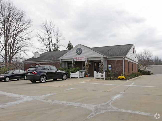
Property Record
517 Highland Rd E, Macedonia, OH 44056


Save to a Folder
{{folder.Name}}
{{folder.ListingIds.length}} Properties
{{folder.ListingIds.length}} Property
Create a New Folder
Property Detail
517 Highland Rd E
Akron, OH
LOT 17 110.45 FT N OF HIGHLAND RD 1.00AC
33-12623
Summit
Commercialnec
Ohio
B and X Area of moderate flood hazard, usually the area between the limits of the 100-year and 500-year floods.
17
2025
0.92 AC
2026
Akron
532701
Cleveland
4,923 SF
NEARBY LISTINGS FOR SALE OR LEASE
DEMOGRAPHICS near 517 Highland Rd E
1 mile
3 mile
5 mile
2025 Total Population
2,583
27,460
67,277
2030 Population
2,561
27,180
66,829
Pop Growth 2025-2030
(0.85%)
(1.02%)
(0.67%)
Average Age
47
44
44
2025 Total Households
1,136
11,008
26,975
HH Growth 2025-2030
(0.88%)
(1.05%)
(0.67%)
Median Household Inc
$86,960
$108,968
$110,212
Avg Household Size
2.30
2.50
2.40
2025 Avg HH Vehicles
2.00
2.00
2.00
Median Home Value
$314,387
$296,324
$320,536
Median Year Built
1995
1985
1985
Nearby Places
Map Layers
Map Styles
 Street
 Aerial
Layers
 Traffic
 Biking
Places
Listings with unknown addresses are not visible on the map
- Restaurants
- Banks
- Shops
- Fitness
- Groceries
PUBLIC TRANSPORTATION
COMMUTER RAIL
Brecksville (National Park Scenic Railway - Cuyahoga Valley Scenic Railroad)
Drive
Walk
Distance
Brecksville (National Park Scenic Railway - Cuyahoga Valley Scenic Railroad)
14 min
5.8 mi
Boston Mill (National Park Scenic Railway - Cuyahoga Valley Scenic Railroad)
Drive
Walk
Distance
Boston Mill (National Park Scenic Railway - Cuyahoga Valley Scenic Railroad)
13 min
6.7 mi
AIRPORT
Cleveland-Hopkins International
Drive
Walk
Distance
Cleveland-Hopkins International
41 min
27.8 mi
Akron-Canton Regional
Drive
Walk
Distance
Akron-Canton Regional
39 min
29.8 mi
Freight Ports
Port of Toledo
Drive
Walk
Distance
Port of Toledo
147 min
126.2 mi
Nearby Properties
Address
Land Use
TOTAL SIZE
Lot Size
Zoning
Address
Land Use
TOTAL SIZE
Lot Size
Zoning
Address
Land Use
TOTAL SIZE
Lot Size
Zoning
315,935 SF
44.94 AC
Address
Land Use
TOTAL SIZE
Lot Size
Zoning
66.58 AC
Address
Land Use
TOTAL SIZE
Lot Size
Zoning
Address
Land Use
TOTAL SIZE
Lot Size
Zoning
1,020,250 SF
63.69 AC
Address
Land Use
TOTAL SIZE
Lot Size
Zoning
230,501 SF
39.59 AC
Address
Land Use
TOTAL SIZE
Lot Size
Zoning
Address
Land Use
TOTAL SIZE
Lot Size
Zoning
270,968 SF
21.68 AC
Address
Land Use
TOTAL SIZE
Lot Size
Zoning
44,697 SF
17.83 AC
Address
Land Use
TOTAL SIZE
Lot Size
Zoning
155,897 SF
19.81 AC
Address
Land Use
TOTAL SIZE
Lot Size
Zoning
254,828 SF
15.41 AC
Address
Land Use
TOTAL SIZE
Lot Size
Zoning
210,136 SF
21.69 AC
Address
Land Use
TOTAL SIZE
Lot Size
Zoning
211,548 SF
14.01 AC
Address
Land Use
TOTAL SIZE
Lot Size
Zoning
290,113 SF
15.05 AC
Address
Land Use
TOTAL SIZE
Lot Size
Zoning
17,423 SF
262 AC
Address
Land Use
TOTAL SIZE
Lot Size
Zoning
263,607 SF
14.69 AC
Address
Land Use
TOTAL SIZE
Lot Size
Zoning
146,666 SF
13.52 AC
Address
Land Use
TOTAL SIZE
Lot Size
Zoning
418,992 SF
27.87 AC
Address
Land Use
TOTAL SIZE
Lot Size
Zoning
266,952 SF
13.15 AC
Address
Land Use
TOTAL SIZE
Lot Size
Zoning
111,145 SF
39.21 AC
Address
Land Use
TOTAL SIZE
Lot Size
Zoning
Address
Land Use
TOTAL SIZE
Lot Size
Zoning
130,822 SF
17.50 AC
Address
Land Use
TOTAL SIZE
Lot Size
Zoning
Address
Land Use
TOTAL SIZE
Lot Size
Zoning
300,900 SF
10.39 AC
Address
Land Use
TOTAL SIZE
Lot Size
Zoning
174,000 SF
20.02 AC
Address
Land Use
TOTAL SIZE
Lot Size
Zoning
136,800 SF
7.86 AC
Address
Land Use
TOTAL SIZE
Lot Size
Zoning
60,908 SF
46.85 AC
Address
Land Use
TOTAL SIZE
Lot Size
Zoning
215,040 SF
14.52 AC
Address
Land Use
TOTAL SIZE
Lot Size
Zoning
Address
Land Use
TOTAL SIZE
Lot Size
Zoning
99,400 SF
3.96 AC
The World's #1 Commercial Real Estate Marketplace
Connect with us
© 2026 CoStar Group
The information above has been obtained from sources believed reliable. While we do not doubt its accuracy we have not verified it and make no guarantee, warranty or representation about it. It is your responsibility to independently confirm its accuracy and completeness. Any projections, opinions, assumptions, or estimates used are for example only and do not represent the current or future performance of the property. The value of this transaction to you depends on tax and other factors which should be evaluated by your tax, financial, and legal advisors. You and your advisors should conduct a careful, independent investigation of the property to determine to your satisfaction the suitability of the property for your needs.