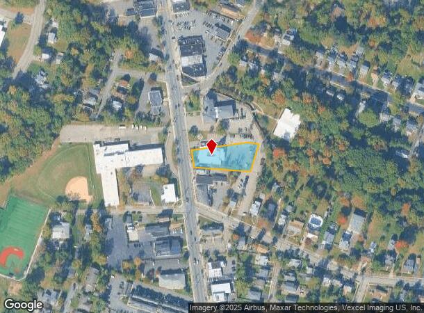
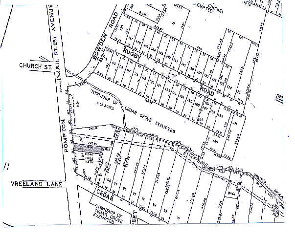
Property Record
517 Pompton Ave, Cedar Grove, NJ 07009

NEARBY LISTINGS FOR SALE OR LEASE
Property Detail
517 Pompton Ave
Newark, NJ
75X263+41X263TRI POST OFFICE
04-00150-0000-00106
Essex
Governmentalpublicusegeneral
New Jersey
X
106
34031C0251G
0.45 AC
0
Suburban Essex/Rt 280
2025
Northern New Jersey
021400
DEMOGRAPHICS near 517 Pompton Ave
1 Mile
3 Mile
5 Mile
2024 Total Population
11,842
126,726
384,527
2029 Population
11,912
125,720
377,543
Pop Growth 2024-2029
+ 0.59%
(0.79%)
(1.82%)
Average Age
44
42
41
2024 Total Households
4,338
47,349
140,534
HH Growth 2024-2029
+ 0.41%
(0.93%)
(1.95%)
Median Household Inc
$152,604
$131,804
$100,245
Avg Household Size
2.60
2.50
2.60
2024 Avg HH Vehicles
2.00
2.00
2.00
Median Home Value
$607,124
$607,162
$471,991
Median Year Built
1958
1955
1955
Nearby Places
Map Layers
Map Styles
 Street
 Aerial
- Restaurants
- Banks
- Shops
- Fitness
- Groceries
PUBLIC TRANSPORTATION
COMMUTER RAIL
Upper Montclair (Montclair-Boonton Line - NJ Transit Commuter Rail (NJ Transit))
DRIVE
WALK
Distance
Upper Montclair (Montclair-Boonton Line - NJ Transit Commuter Rail (NJ Transit))
5 min
1.7 mi
Montclair Heights (Montclair-Boonton Line - NJ Transit Commuter Rail (NJ Transit))
DRIVE
WALK
Distance
Montclair Heights (Montclair-Boonton Line - NJ Transit Commuter Rail (NJ Transit))
5 min
1.9 mi
AIRPORT
Newark Liberty International
DRIVE
WALK
Distance
Newark Liberty International
28 min
19.3 mi
LaGuardia
DRIVE
WALK
Distance
LaGuardia
47 min
31.2 mi
John F Kennedy International
DRIVE
WALK
Distance
John F Kennedy International
59 min
33.9 mi
Freight Ports
Maher Terminal
DRIVE
WALK
Distance
Maher Terminal
33 min
17.4 mi
Nearby Properties
Address
Land Use
TOTAL SIZE
Lot Size
Zoning
Address
Land Use
TOTAL SIZE
Lot Size
Zoning
74.58 AC
S
Address
Land Use
TOTAL SIZE
Lot Size
Zoning
28.33 AC
Address
Land Use
TOTAL SIZE
Lot Size
Zoning
1,589 SF
R4
Address
Land Use
TOTAL SIZE
Lot Size
Zoning
Address
Land Use
TOTAL SIZE
Lot Size
Zoning
260,609 SF
35.39 AC
Address
Land Use
TOTAL SIZE
Lot Size
Zoning
20.43 AC
Address
Land Use
TOTAL SIZE
Lot Size
Zoning
2.87 AC
Address
Land Use
TOTAL SIZE
Lot Size
Zoning
32.34 AC
RA
Address
Land Use
TOTAL SIZE
Lot Size
Zoning
1.50 AC
RA
Address
Land Use
TOTAL SIZE
Lot Size
Zoning
315,332 SF
19.60 AC
Address
Land Use
TOTAL SIZE
Lot Size
Zoning
3.55 AC
Address
Land Use
TOTAL SIZE
Lot Size
Zoning
25.88 AC
Address
Land Use
TOTAL SIZE
Lot Size
Zoning
25.80 AC
P
Address
Land Use
TOTAL SIZE
Lot Size
Zoning
271,679 SF
20.79 AC
Address
Land Use
TOTAL SIZE
Lot Size
Zoning
1,760 SF
189.03 AC
R-2
Address
Land Use
TOTAL SIZE
Lot Size
Zoning
49.03 AC
Address
Land Use
TOTAL SIZE
Lot Size
Zoning
5.74 AC
B-2
Address
Land Use
TOTAL SIZE
Lot Size
Zoning
Address
Land Use
TOTAL SIZE
Lot Size
Zoning
15.80 AC
IND
Address
Land Use
TOTAL SIZE
Lot Size
Zoning
14.27 AC
RO
Address
Land Use
TOTAL SIZE
Lot Size
Zoning
7,507 SF
18.82 AC
L-1
Address
Land Use
TOTAL SIZE
Lot Size
Zoning
4.08 AC
Address
Land Use
TOTAL SIZE
Lot Size
Zoning
17.48 AC
M-2
Address
Land Use
TOTAL SIZE
Lot Size
Zoning
1,063 SF
14.08 AC
C-1
Address
Land Use
TOTAL SIZE
Lot Size
Zoning
130,000 SF
11 AC
Address
Land Use
TOTAL SIZE
Lot Size
Zoning
10.72 AC
Address
Land Use
TOTAL SIZE
Lot Size
Zoning
5.06 AC
Address
Land Use
TOTAL SIZE
Lot Size
Zoning
186,856 SF
10.47 AC
Address
Land Use
TOTAL SIZE
Lot Size
Zoning
2.22 AC
Address
Land Use
TOTAL SIZE
Lot Size
Zoning
439,114 SF
19.21 AC
The World's #1 Commercial Real Estate Marketplace
Connect with us
© 2026 CoStar Group
The information above has been obtained from sources believed reliable. While we do not doubt its accuracy we have not verified it and make no guarantee, warranty or representation about it. It is your responsibility to independently confirm its accuracy and completeness. Any projections, opinions, assumptions, or estimates used are for example only and do not represent the current or future performance of the property. The value of this transaction to you depends on tax and other factors which should be evaluated by your tax, financial, and legal advisors. You and your advisors should conduct a careful, independent investigation of the property to determine to your satisfaction the suitability of the property for your needs.