Property Record
517 Willingham Rd, Williamston, SC 29697
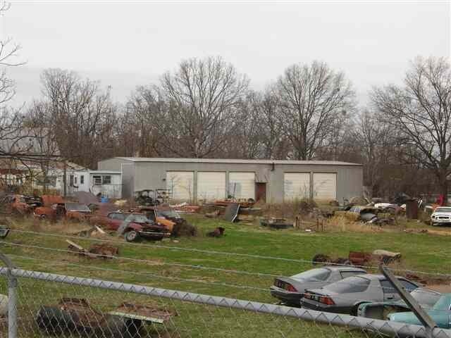

Property Detail
517 Willingham Rd
222-00-04-004
CP 108/004331 F00000 D00000 PP 000/000000 WILLINGHAM RD 2.58 AC
Commercialnec
Anderson
B and X Area of moderate flood hazard, usually the area between the limits of the 100-year and 500-year floods.
South Carolina
2025
2.58 AC
2025
Anderson Cy S of I-85
010405
Greenville/Spartanburg
2,400 SF
Greenville-Anderson-Greer, SC
NEARBY LISTINGS FOR SALE OR LEASE
-
-
View all Williamston listings for sale on LoopNet.com
DEMOGRAPHICS near 517 Willingham Rd
1 mile
3 mile
5 mile
2025 Total Population
998
9,548
25,186
2030 Population
1,048
10,020
26,541
Pop Growth 2025-2030
+ 5.01%
+ 4.94%
+ 5.38%
Average Age
40
40
40
2025 Total Households
372
3,642
9,691
HH Growth 2025-2030
+ 5.11%
+ 5.19%
+ 5.64%
Median Household Inc
$52,439
$63,384
$63,091
Avg Household Size
2.60
2.60
2.60
2025 Avg HH Vehicles
2.00
2.00
2.00
Median Home Value
$185,416
$209,243
$210,701
Median Year Built
1992
1990
1987
Nearby Places
Map Layers
Map Styles
 Street
 Aerial
Transit
 Traffic
 Biking
Places
Listings with unknown addresses are not visible on the map
- Restaurants
- Banks
- Shops
- Fitness
- Groceries
PUBLIC TRANSPORTATION
AIRPORT
Greenville Spartanburg International
Drive
Walk
Distance
Greenville Spartanburg International
45 min
31.8 mi
Nearby Properties
Address
Land Use
TOTAL SIZE
Lot Size
Zoning
Address
Land Use
TOTAL SIZE
Lot Size
Zoning
19,038 SF
10.44 AC
Address
Land Use
TOTAL SIZE
Lot Size
Zoning
34.46 AC
Address
Land Use
TOTAL SIZE
Lot Size
Zoning
10,583 SF
2.32 AC
Address
Land Use
TOTAL SIZE
Lot Size
Zoning
1,546 SF
1.16 AC
Address
Land Use
TOTAL SIZE
Lot Size
Zoning
5,882 SF
19.01 AC
Address
Land Use
TOTAL SIZE
Lot Size
Zoning
11.53 AC
Address
Land Use
TOTAL SIZE
Lot Size
Zoning
22,080 SF
2.22 AC
Address
Land Use
TOTAL SIZE
Lot Size
Zoning
8,000 SF
1.03 AC
Address
Land Use
TOTAL SIZE
Lot Size
Zoning
29,538 SF
12.68 AC
Address
Land Use
TOTAL SIZE
Lot Size
Zoning
4,436 SF
0.67 AC
Address
Land Use
TOTAL SIZE
Lot Size
Zoning
11,292 SF
7.46 AC
Address
Land Use
TOTAL SIZE
Lot Size
Zoning
8,851 SF
179.78 AC
Address
Land Use
TOTAL SIZE
Lot Size
Zoning
3,440 SF
2.03 AC
Address
Land Use
TOTAL SIZE
Lot Size
Zoning
24,070 SF
1.71 AC
Address
Land Use
TOTAL SIZE
Lot Size
Zoning
8,000 SF
1.76 AC
Address
Land Use
TOTAL SIZE
Lot Size
Zoning
19,900 SF
2.05 AC
Address
Land Use
TOTAL SIZE
Lot Size
Zoning
2,024 SF
0.73 AC
Address
Land Use
TOTAL SIZE
Lot Size
Zoning
3,536 SF
0.90 AC
Address
Land Use
TOTAL SIZE
Lot Size
Zoning
7,578 SF
0.84 AC
Address
Land Use
TOTAL SIZE
Lot Size
Zoning
1,568 SF
0.94 AC
Address
Land Use
TOTAL SIZE
Lot Size
Zoning
1,785 SF
0.52 AC
Address
Land Use
TOTAL SIZE
Lot Size
Zoning
2,639 SF
0.82 AC
Address
Land Use
TOTAL SIZE
Lot Size
Zoning
15 AC
Address
Land Use
TOTAL SIZE
Lot Size
Zoning
3,000 SF
9.03 AC
Address
Land Use
TOTAL SIZE
Lot Size
Zoning
23.38 AC
Address
Land Use
TOTAL SIZE
Lot Size
Zoning
15,128 SF
1.69 AC
Address
Land Use
TOTAL SIZE
Lot Size
Zoning
10,000 SF
0.78 AC
Address
Land Use
TOTAL SIZE
Lot Size
Zoning
107,964 SF
27.09 AC
The World's #1 Commercial Real Estate Marketplace
Connect with us
© 2026 CoStar Group
The information above has been obtained from sources believed reliable. While we do not doubt its accuracy we have not verified it and make no guarantee, warranty or representation about it. It is your responsibility to independently confirm its accuracy and completeness. Any projections, opinions, assumptions, or estimates used are for example only and do not represent the current or future performance of the property. The value of this transaction to you depends on tax and other factors which should be evaluated by your tax, financial, and legal advisors. You and your advisors should conduct a careful, independent investigation of the property to determine to your satisfaction the suitability of the property for your needs.