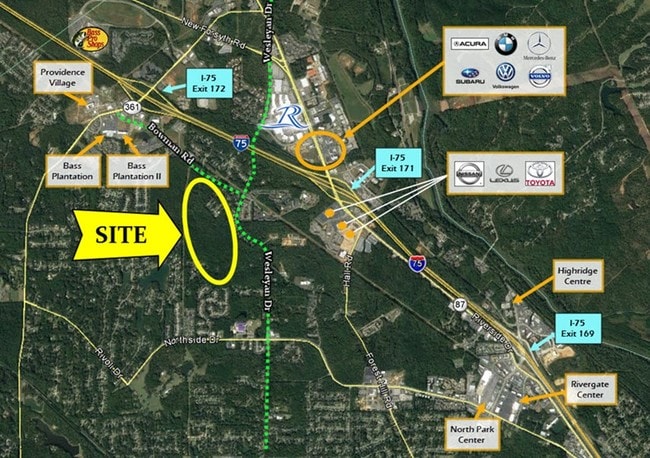
Property Record
5171 Bowman Rd, Macon, GA 31210


Save to a Folder
{{folder.Name}}
{{folder.ListingIds.length}} Properties
{{folder.ListingIds.length}} Property
Create a New Folder
Property Detail
5171 Bowman Rd
L003-0001
BIBB
Countryclub
Georgia
R-1AA
281&282
A Areas with a 1% annual chance of flooding and a 26% chance of flooding over the life of a 30-year mortgage.
102.72 AC
2025
Outlying Bibb County
2025
Atlanta
013408
Macon-Bibb County, GA
5,376 SF
NEARBY LISTINGS FOR SALE OR LEASE
DEMOGRAPHICS near 5171 Bowman Rd
1 mile
3 mile
5 mile
2025 Total Population
4,982
22,767
47,256
2030 Population
4,933
22,666
47,218
Pop Growth 2025-2030
(0.98%)
(0.44%)
(0.08%)
Average Age
39
40
40
2025 Total Households
2,220
9,770
19,632
HH Growth 2025-2030
(0.81%)
(0.51%)
(0.13%)
Median Household Inc
$82,102
$84,277
$84,550
Avg Household Size
2.20
2.30
2.30
2025 Avg HH Vehicles
2.00
2.00
2.00
Median Home Value
$303,584
$299,645
$274,984
Median Year Built
1995
1991
1988
Nearby Places
Map Layers
Map Styles
 Street
 Aerial
Layers
 Traffic
 Biking
Places
Listings with unknown addresses are not visible on the map
- Restaurants
- Banks
- Shops
- Fitness
- Groceries
SALE & LEASE HISTORY
LISTING DATE
SALE/LEASE

Sep 08, 2017
For Sale
Sep 06, 2017
For Sale
Nearby Properties
Address
Land Use
TOTAL SIZE
Lot Size
Zoning
Address
Land Use
TOTAL SIZE
Lot Size
Zoning
83,990 SF
42.03 AC
C-2
Address
Land Use
TOTAL SIZE
Lot Size
Zoning
Address
Land Use
TOTAL SIZE
Lot Size
Zoning
298,760 SF
60.24 AC
PDE
Address
Land Use
TOTAL SIZE
Lot Size
Zoning
3,204 SF
49.78 AC
R-3
Address
Land Use
TOTAL SIZE
Lot Size
Zoning
2,559 SF
45.58 AC
R-3
Address
Land Use
TOTAL SIZE
Lot Size
Zoning
83,104 SF
20.39 AC
PDE
Address
Land Use
TOTAL SIZE
Lot Size
Zoning
4,671 SF
22.66 AC
R-3
Address
Land Use
TOTAL SIZE
Lot Size
Zoning
94,879 SF
18.77 AC
C-4
Address
Land Use
TOTAL SIZE
Lot Size
Zoning
6,222 SF
56.17 AC
PDR
Address
Land Use
TOTAL SIZE
Lot Size
Zoning
211,536 SF
16.48 AC
C-2
Address
Land Use
TOTAL SIZE
Lot Size
Zoning
62,688 SF
32.47 AC
R-3
Address
Land Use
TOTAL SIZE
Lot Size
Zoning
194,734 SF
6.37 AC
C-2
Address
Land Use
TOTAL SIZE
Lot Size
Zoning
5,684 SF
29.99 AC
PDE
Address
Land Use
TOTAL SIZE
Lot Size
Zoning
185,591 SF
38.16 AC
PDE
Address
Land Use
TOTAL SIZE
Lot Size
Zoning
48,696 SF
23.70 AC
PDE
Address
Land Use
TOTAL SIZE
Lot Size
Zoning
172,808 SF
38.40 AC
C-4/PDE
Address
Land Use
TOTAL SIZE
Lot Size
Zoning
4,734 SF
40 AC
PDE
Address
Land Use
TOTAL SIZE
Lot Size
Zoning
71,021 SF
8.94 AC
PDC
Address
Land Use
TOTAL SIZE
Lot Size
Zoning
61,540 SF
130.80 AC
A
Address
Land Use
TOTAL SIZE
Lot Size
Zoning
3,902 SF
53.40 AC
PDE
Address
Land Use
TOTAL SIZE
Lot Size
Zoning
133,220 SF
9.15 AC
C-2
Address
Land Use
TOTAL SIZE
Lot Size
Zoning
51,786 SF
21.05 AC
PDR
Address
Land Use
TOTAL SIZE
Lot Size
Zoning
162,132 SF
21.95 AC
PDE
Address
Land Use
TOTAL SIZE
Lot Size
Zoning
55,536 SF
20.36 AC
PDE
Address
Land Use
TOTAL SIZE
Lot Size
Zoning
1,452 SF
12.16 AC
R-3
Address
Land Use
TOTAL SIZE
Lot Size
Zoning
125,073 SF
4.89 AC
R-3
Address
Land Use
TOTAL SIZE
Lot Size
Zoning
70,900 SF
2.19 AC
PDE
Address
Land Use
TOTAL SIZE
Lot Size
Zoning
79,904 SF
5.05 AC
PDE
Address
Land Use
TOTAL SIZE
Lot Size
Zoning
3,036 SF
17.32 AC
PDE
The World's #1 Commercial Real Estate Marketplace
Connect with us
© 2026 CoStar Group
The information above has been obtained from sources believed reliable. While we do not doubt its accuracy we have not verified it and make no guarantee, warranty or representation about it. It is your responsibility to independently confirm its accuracy and completeness. Any projections, opinions, assumptions, or estimates used are for example only and do not represent the current or future performance of the property. The value of this transaction to you depends on tax and other factors which should be evaluated by your tax, financial, and legal advisors. You and your advisors should conduct a careful, independent investigation of the property to determine to your satisfaction the suitability of the property for your needs.