Property Record
5171 Lee Hwy, Warrenton, VA 20187
NEARBY LISTINGS FOR SALE OR LEASE
-
-
View all Warrenton listings for sale on LoopNet.com
Property Detail
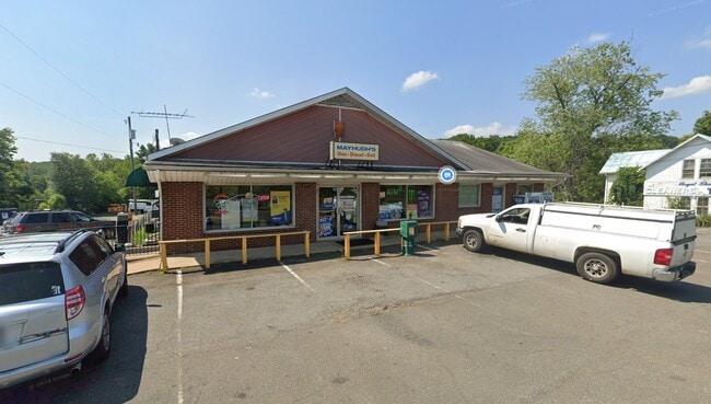
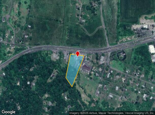
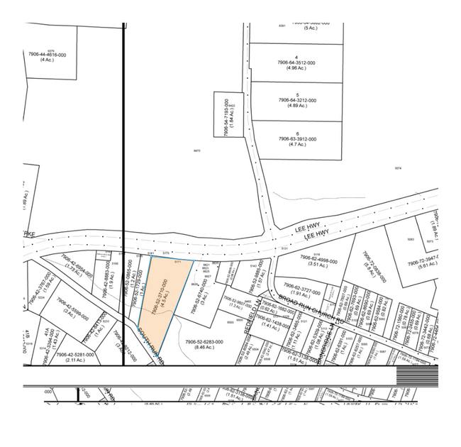
5171 Lee Hwy
7906-52-3710
NOT PROVIDED. PARCEL NUMBER 43025
Multipleuses
Fauquier
AE
Virginia
51061C0240D
4.50 AC
2025
Fauquier County/Vint Hill
2025
Washington, DC
930402
Washington-Arlington-Alexandria, DC-VA-MD-WV
12,400 SF
DEMOGRAPHICS near 5171 Lee Hwy
1 Mile
3 Mile
5 Mile
2024 Total Population
1,216
13,358
35,154
2029 Population
1,280
14,051
37,072
Pop Growth 2024-2029
+ 5.26%
+ 5.19%
+ 5.46%
Average Age
43
40
40
2024 Total Households
429
4,410
11,732
HH Growth 2024-2029
+ 5.36%
+ 5.28%
+ 5.52%
Median Household Inc
$160,882
$170,451
$153,159
Avg Household Size
2.80
3.00
2.90
2024 Avg HH Vehicles
3.00
3.00
3.00
Median Home Value
$627,705
$609,504
$593,542
Median Year Built
1989
1993
1998
Nearby Places
- Restaurants
- Banks
- Shops
- Fitness
- Groceries
PUBLIC TRANSPORTATION
AIRPORT
Washington Dulles International
DRIVE
WALK
Distance
Washington Dulles International
43 min
28.4 mi
Freight Ports
Port of Baltimore
DRIVE
WALK
Distance
Port of Baltimore
102 min
78.8 mi
Nearby Properties
Address
Land Use
TOTAL SIZE
Lot Size
Zoning
Address
Land Use
TOTAL SIZE
Lot Size
Zoning
85,000 SF
30 AC
AGRICULTUR
Address
Land Use
TOTAL SIZE
Lot Size
Zoning
10.23 AC
PLANNED CO
Address
Land Use
TOTAL SIZE
Lot Size
Zoning
118,443 SF
34.58 AC
RES, 1 DWE
Address
Land Use
TOTAL SIZE
Lot Size
Zoning
84,199 SF
8.57 AC
PLANNED CO
Address
Land Use
TOTAL SIZE
Lot Size
Zoning
68,418 SF
3.15 AC
AGRICULTUR
Address
Land Use
TOTAL SIZE
Lot Size
Zoning
71,888 SF
27.74 AC
RES 1 DWEL
Address
Land Use
TOTAL SIZE
Lot Size
Zoning
53,280 SF
4.39 AC
PLANNED CO
Address
Land Use
TOTAL SIZE
Lot Size
Zoning
87,488 SF
12.23 AC
INDUSTRIAL
Address
Land Use
TOTAL SIZE
Lot Size
Zoning
54,612 SF
8 AC
AGRICULTUR
Address
Land Use
TOTAL SIZE
Lot Size
Zoning
59,784 SF
10 AC
PLANNED CO
Address
Land Use
TOTAL SIZE
Lot Size
Zoning
42,776 SF
3.13 AC
PLANNED CO
Address
Land Use
TOTAL SIZE
Lot Size
Zoning
28,032 SF
6.82 AC
PLANNED CO
Address
Land Use
TOTAL SIZE
Lot Size
Zoning
24,148 SF
18.16 AC
PLANNED CO
Address
Land Use
TOTAL SIZE
Lot Size
Zoning
29.38 AC
PLANNED CO
Address
Land Use
TOTAL SIZE
Lot Size
Zoning
14,640 SF
3.32 AC
PLANNED CO
Address
Land Use
TOTAL SIZE
Lot Size
Zoning
2,000 SF
25.24 AC
PLANNED CO
Address
Land Use
TOTAL SIZE
Lot Size
Zoning
15,920 SF
3 AC
COMMERCIAL
Address
Land Use
TOTAL SIZE
Lot Size
Zoning
11,200 SF
6.13 AC
COMMERCIAL
Address
Land Use
TOTAL SIZE
Lot Size
Zoning
31,692 SF
2.50 AC
PLANNED CO
Address
Land Use
TOTAL SIZE
Lot Size
Zoning
9,344 SF
14.52 AC
PLANNED CO
Address
Land Use
TOTAL SIZE
Lot Size
Zoning
18,100 SF
6.64 AC
INDUSTRIAL
Address
Land Use
TOTAL SIZE
Lot Size
Zoning
2,900 SF
3.51 AC
COMMERCIAL
Address
Land Use
TOTAL SIZE
Lot Size
Zoning
18.20 AC
PLANNED CO
Address
Land Use
TOTAL SIZE
Lot Size
Zoning
48,205 SF
2.96 AC
PLANNED CO
Address
Land Use
TOTAL SIZE
Lot Size
Zoning
1,412 SF
3 AC
COMMERCIAL
Address
Land Use
TOTAL SIZE
Lot Size
Zoning
19,000 SF
4.46 AC
PLANNED CO
Address
Land Use
TOTAL SIZE
Lot Size
Zoning
10,640 SF
5 AC
INDUSTRIAL
Address
Land Use
TOTAL SIZE
Lot Size
Zoning
32,896 SF
0.76 AC
PLANNED CO
Address
Land Use
TOTAL SIZE
Lot Size
Zoning
15.28 AC
PLANNED CO
Address
Land Use
TOTAL SIZE
Lot Size
Zoning
18,657 SF
5.61 AC
COMMERCIAL
The World's #1 Commercial Real Estate Marketplace
Connect with us
© 2025 CoStar Group
The information above has been obtained from sources believed reliable. While we do not doubt its accuracy we have not verified it and make no guarantee, warranty or representation about it. It is your responsibility to independently confirm its accuracy and completeness. Any projections, opinions, assumptions, or estimates used are for example only and do not represent the current or future performance of the property. The value of this transaction to you depends on tax and other factors which should be evaluated by your tax, financial, and legal advisors. You and your advisors should conduct a careful, independent investigation of the property to determine to your satisfaction the suitability of the property for your needs.