Property Record
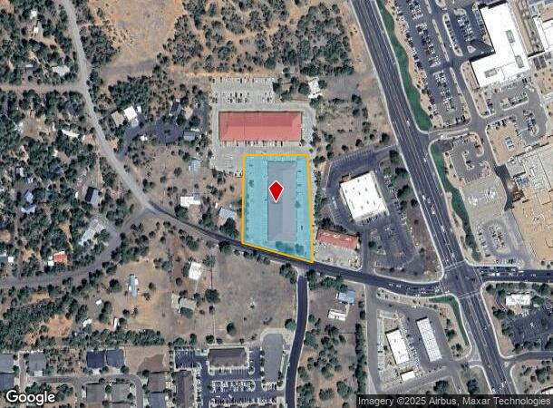
5171 S Cub Lake Rd, Show Low, AZ 85901
NEARBY LISTINGS FOR SALE OR LEASE
Property Detail
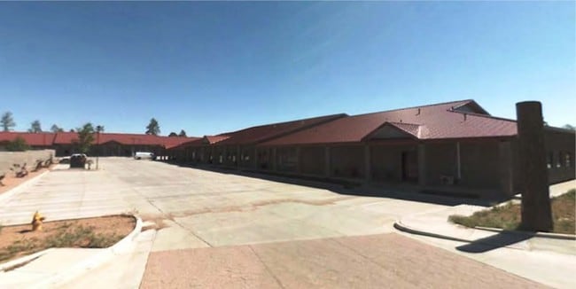
5171 S Cub Lake Rd
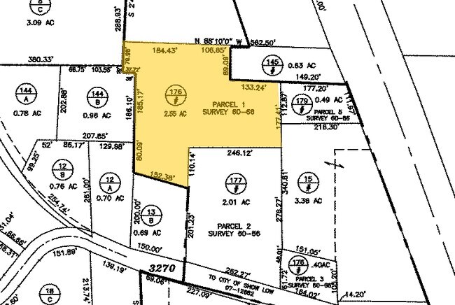
212-03-177
Ellsworth Heights
Regionalshoppingcenterormallwithanchorstore
SEC 4, T9N, R22E:PARCEL 2, PER SURVEY 60-66. AKA:COM W4 COR SEC 4; TH S02*02'54 E 1374.62'; TH N80*52'48 E 930.75' TPOB; TH N01*36'44 E 311.37'; TH S90*00 '00E 246.12'; TH S00*27'16 E 276.27'; THS06*16'02 W 46.01'; TH S00*00'00 E 61.72'; TH N73*57'27
X
Navajo
04017C4709F
Arizona
2024
2.01 AC
2026
Arizona Northeast & Holbrook Area
961702
Other Market Areas
22,400 SF
Show Low, AZ
DEMOGRAPHICS near 5171 S Cub Lake Rd
1 Mile
3 Mile
5 Mile
2024 Total Population
3,787
8,746
23,855
2029 Population
4,200
9,550
25,905
Pop Growth 2024-2029
+ 10.91%
+ 9.19%
+ 8.59%
Average Age
45
45
43
2024 Total Households
1,516
3,517
9,657
HH Growth 2024-2029
+ 10.82%
+ 9.07%
+ 8.51%
Median Household Inc
$52,658
$54,873
$54,597
Avg Household Size
2.40
2.40
2.40
2024 Avg HH Vehicles
2.00
2.00
2.00
Median Home Value
$220,912
$250,707
$220,833
Median Year Built
1999
1998
1994
Nearby Places
Map Layers
Map Styles
 Street
 Aerial
- Restaurants
- Banks
- Shops
- Fitness
- Groceries
SALE & LEASE HISTORY
LISTING DATE
SALE/LEASE

Nov 25, 2019
For Lease
Nearby Properties
Address
Land Use
TOTAL SIZE
Lot Size
Zoning
Address
Land Use
TOTAL SIZE
Lot Size
Zoning
203,623 SF
14 AC
MUNICIPAL
Address
Land Use
TOTAL SIZE
Lot Size
Zoning
138,315 SF
13.91 AC
MUNICIPAL
Address
Land Use
TOTAL SIZE
Lot Size
Zoning
55,688 SF
1.50 AC
C-R
Address
Land Use
TOTAL SIZE
Lot Size
Zoning
74,338 SF
2.29 AC
Address
Land Use
TOTAL SIZE
Lot Size
Zoning
83,087 SF
5.08 AC
MUNICIPAL
Address
Land Use
TOTAL SIZE
Lot Size
Zoning
56,096 SF
1.48 AC
C-R
Address
Land Use
TOTAL SIZE
Lot Size
Zoning
56,331 SF
16.30 AC
MUNICIPAL
Address
Land Use
TOTAL SIZE
Lot Size
Zoning
44,764 SF
1.51 AC
MUNICIPAL
Address
Land Use
TOTAL SIZE
Lot Size
Zoning
97,790 SF
4.80 AC
MUNICIPAL
Address
Land Use
TOTAL SIZE
Lot Size
Zoning
86,443 SF
6.85 AC
MUNICIPAL
Address
Land Use
TOTAL SIZE
Lot Size
Zoning
30,942 SF
3.21 AC
MUNICIPAL
Address
Land Use
TOTAL SIZE
Lot Size
Zoning
26,530 SF
3.88 AC
C-R
Address
Land Use
TOTAL SIZE
Lot Size
Zoning
22,680 SF
1.65 AC
C-R
Address
Land Use
TOTAL SIZE
Lot Size
Zoning
42,868 SF
2.45 AC
MUNICIPAL
Address
Land Use
TOTAL SIZE
Lot Size
Zoning
48,320 SF
5 AC
C-R
Address
Land Use
TOTAL SIZE
Lot Size
Zoning
47,586 SF
3.50 AC
MUNICIPAL
Address
Land Use
TOTAL SIZE
Lot Size
Zoning
22,400 SF
2.55 AC
MUNICIPAL
Address
Land Use
TOTAL SIZE
Lot Size
Zoning
35,090 SF
3.40 AC
MUNICIPAL
Address
Land Use
TOTAL SIZE
Lot Size
Zoning
16,157 SF
4.56 AC
R1-10
Address
Land Use
TOTAL SIZE
Lot Size
Zoning
18,000 SF
2.09 AC
MUNICIPAL
Address
Land Use
TOTAL SIZE
Lot Size
Zoning
28,700 SF
2.76 AC
MUNICIPAL
Address
Land Use
TOTAL SIZE
Lot Size
Zoning
22,705 SF
3.74 AC
MUNICIPAL
Address
Land Use
TOTAL SIZE
Lot Size
Zoning
10,880 SF
1.36 AC
MUNICIPAL
Address
Land Use
TOTAL SIZE
Lot Size
Zoning
15,073 SF
3.36 AC
MUNICIPAL
Address
Land Use
TOTAL SIZE
Lot Size
Zoning
19,369 SF
17.26 AC
MUNICIPAL
Address
Land Use
TOTAL SIZE
Lot Size
Zoning
21,333 SF
2.14 AC
C-R
Address
Land Use
TOTAL SIZE
Lot Size
Zoning
7,328 SF
1.82 AC
MUNICIPAL
The World's #1 Commercial Real Estate Marketplace
Connect with us
© 2025 CoStar Group
The information above has been obtained from sources believed reliable. While we do not doubt its accuracy we have not verified it and make no guarantee, warranty or representation about it. It is your responsibility to independently confirm its accuracy and completeness. Any projections, opinions, assumptions, or estimates used are for example only and do not represent the current or future performance of the property. The value of this transaction to you depends on tax and other factors which should be evaluated by your tax, financial, and legal advisors. You and your advisors should conduct a careful, independent investigation of the property to determine to your satisfaction the suitability of the property for your needs.