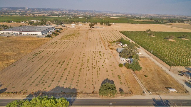
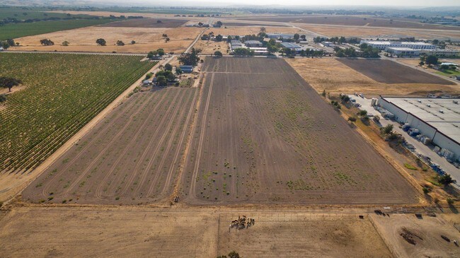
Property Record
5175 Airport Rd, Paso Robles, CA 93446


NEARBY LISTINGS FOR SALE OR LEASE
Property Detail
5175 Airport Rd
025-434-002
Parcel Map No Co 72 330
Industrialacreage
CY PR PM 84/42-43 PTN PAR 1 LESS RD
X
San Luis Obispo
06079C0392H
California
2024
9.70 AC
2025
North 101 Corridor
010303
San Luis Obispo/Paso Robles
2,557 SF
San Luis Obispo-Paso Robles-Arroyo Grande, CA
DEMOGRAPHICS near 5175 Airport Rd
1 Mile
3 Mile
5 Mile
2024 Total Population
94
4,762
30,862
2029 Population
93
4,700
30,586
Pop Growth 2024-2029
(1.06%)
(1.30%)
(0.89%)
Average Age
43
43
40
2024 Total Households
34
1,737
11,299
HH Growth 2024-2029
(2.94%)
(1.44%)
(1.04%)
Median Household Inc
$91,666
$106,094
$80,813
Avg Household Size
2.80
2.70
2.70
2024 Avg HH Vehicles
2.00
2.00
2.00
Median Home Value
$849,999
$662,777
$612,778
Median Year Built
1987
1999
1986
Nearby Places
Map Layers
Map Styles
 Street
 Aerial
- Restaurants
- Banks
- Shops
- Fitness
- Groceries
PUBLIC TRANSPORTATION
COMMUTER RAIL
Paso Robles Amtrak Station (Coast Starlight - Amtrak)
DRIVE
WALK
Distance
Paso Robles Amtrak Station (Coast Starlight - Amtrak)
15 min
5.8 mi
Freight Ports
The Port of Hueneme
DRIVE
WALK
Distance
The Port of Hueneme
215 min
166.9 mi
SALE & LEASE HISTORY
LISTING DATE
SALE/LEASE

Sep 14, 2017
For Sale
Nearby Properties
Address
Land Use
TOTAL SIZE
Lot Size
Zoning
Address
Land Use
TOTAL SIZE
Lot Size
Zoning
197,140 SF
11.87 AC
R3
Address
Land Use
TOTAL SIZE
Lot Size
Zoning
115,054 SF
18.78 AC
PM
Address
Land Use
TOTAL SIZE
Lot Size
Zoning
127,770 SF
27.72 AC
AG
Address
Land Use
TOTAL SIZE
Lot Size
Zoning
129,241 SF
18.91 AC
POS
Address
Land Use
TOTAL SIZE
Lot Size
Zoning
77,710 SF
44 AC
AG
Address
Land Use
TOTAL SIZE
Lot Size
Zoning
63.59 AC
POS
Address
Land Use
TOTAL SIZE
Lot Size
Zoning
24.74 AC
AG
Address
Land Use
TOTAL SIZE
Lot Size
Zoning
152,938 SF
13.60 AC
M
Address
Land Use
TOTAL SIZE
Lot Size
Zoning
34.76 AC
Address
Land Use
TOTAL SIZE
Lot Size
Zoning
91,903 SF
5.10 AC
POS
Address
Land Use
TOTAL SIZE
Lot Size
Zoning
11.53 AC
C3
Address
Land Use
TOTAL SIZE
Lot Size
Zoning
Address
Land Use
TOTAL SIZE
Lot Size
Zoning
65,931 SF
3.16 AC
PM
Address
Land Use
TOTAL SIZE
Lot Size
Zoning
14,995 SF
10.74 AC
Address
Land Use
TOTAL SIZE
Lot Size
Zoning
14.75 AC
Address
Land Use
TOTAL SIZE
Lot Size
Zoning
Address
Land Use
TOTAL SIZE
Lot Size
Zoning
28,050 SF
2.01 AC
PM
Address
Land Use
TOTAL SIZE
Lot Size
Zoning
4.20 AC
AP
Address
Land Use
TOTAL SIZE
Lot Size
Zoning
1,584 SF
255.80 AC
AG
Address
Land Use
TOTAL SIZE
Lot Size
Zoning
31,458 SF
3.99 AC
PM
Address
Land Use
TOTAL SIZE
Lot Size
Zoning
6,025 SF
224.27 AC
POS
Address
Land Use
TOTAL SIZE
Lot Size
Zoning
201.46 AC
Address
Land Use
TOTAL SIZE
Lot Size
Zoning
72,118 SF
4.30 AC
AP
Address
Land Use
TOTAL SIZE
Lot Size
Zoning
28,374 SF
5.19 AC
PM
Address
Land Use
TOTAL SIZE
Lot Size
Zoning
1,284 SF
84 AC
AG
Address
Land Use
TOTAL SIZE
Lot Size
Zoning
4.90 AC
C3
Address
Land Use
TOTAL SIZE
Lot Size
Zoning
160 AC
AG
Address
Land Use
TOTAL SIZE
Lot Size
Zoning
149.62 AC
AG
Address
Land Use
TOTAL SIZE
Lot Size
Zoning
29,800 SF
11.48 AC
C3
The World's #1 Commercial Real Estate Marketplace
Connect with us
© 2025 CoStar Group
The information above has been obtained from sources believed reliable. While we do not doubt its accuracy we have not verified it and make no guarantee, warranty or representation about it. It is your responsibility to independently confirm its accuracy and completeness. Any projections, opinions, assumptions, or estimates used are for example only and do not represent the current or future performance of the property. The value of this transaction to you depends on tax and other factors which should be evaluated by your tax, financial, and legal advisors. You and your advisors should conduct a careful, independent investigation of the property to determine to your satisfaction the suitability of the property for your needs.