Property Record
5175 N Highway 763, Columbia, MO 65202
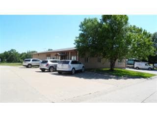


This Property Is For Sale
Current Lease Availabilities
NEARBY LISTINGS FOR SALE OR LEASE
Property Detail
5175 N Highway 763
Columbia, MO
Shalimar Gardens
11-908-25-01-049-00-01
SHALIMAR GARDENS PLAT 1A LOT 2A
Publicstorage
Boone
X
Missouri
29019C0165D
3
2025
1.68 AC
2025
Columbia/Jefferson City
001401
Other Market Areas
3,784 SF
DEMOGRAPHICS near 5175 N Highway 763
1 Mile
3 Mile
5 Mile
2024 Total Population
5,839
27,925
86,715
2029 Population
6,235
29,739
91,959
Pop Growth 2024-2029
+ 6.78%
+ 6.50%
+ 6.05%
Average Age
35
37
35
2024 Total Households
2,070
11,135
34,910
HH Growth 2024-2029
+ 6.96%
+ 6.67%
+ 6.58%
Median Household Inc
$71,249
$67,701
$48,879
Avg Household Size
2.60
2.40
2.20
2024 Avg HH Vehicles
2.00
2.00
2.00
Median Home Value
$181,638
$178,446
$180,933
Median Year Built
2000
1995
1986
Nearby Places
Map Layers
Map Styles
 Street
 Aerial
- Restaurants
- Banks
- Shops
- Fitness
- Groceries
PUBLIC TRANSPORTATION
AIRPORT
Columbia Regional
DRIVE
WALK
Distance
Columbia Regional
22 min
17.3 mi
Nearby Properties
Address
Land Use
TOTAL SIZE
Lot Size
Zoning
Address
Land Use
TOTAL SIZE
Lot Size
Zoning
321,295 SF
79.83 AC
Address
Land Use
TOTAL SIZE
Lot Size
Zoning
87,060 SF
0.37 AC
R3
Address
Land Use
TOTAL SIZE
Lot Size
Zoning
184,413 SF
17.63 AC
CP
Address
Land Use
TOTAL SIZE
Lot Size
Zoning
56,305 SF
12 AC
CP
Address
Land Use
TOTAL SIZE
Lot Size
Zoning
151,550 SF
53.69 AC
MC
Address
Land Use
TOTAL SIZE
Lot Size
Zoning
35,436 SF
19.09 AC
Address
Land Use
TOTAL SIZE
Lot Size
Zoning
83,978 SF
8.60 AC
C3
Address
Land Use
TOTAL SIZE
Lot Size
Zoning
167,255 SF
14.14 AC
Address
Land Use
TOTAL SIZE
Lot Size
Zoning
63,121 SF
11.28 AC
Address
Land Use
TOTAL SIZE
Lot Size
Zoning
41,600 SF
5.42 AC
Address
Land Use
TOTAL SIZE
Lot Size
Zoning
276,234 SF
14.78 AC
C3
Address
Land Use
TOTAL SIZE
Lot Size
Zoning
5,200 SF
11 AC
M1
Address
Land Use
TOTAL SIZE
Lot Size
Zoning
88,738 SF
3.55 AC
CP
Address
Land Use
TOTAL SIZE
Lot Size
Zoning
65,759 SF
4.90 AC
MC
Address
Land Use
TOTAL SIZE
Lot Size
Zoning
113.90 AC
M1
Address
Land Use
TOTAL SIZE
Lot Size
Zoning
50,852 SF
10.64 AC
C3
Address
Land Use
TOTAL SIZE
Lot Size
Zoning
117,114 SF
7.66 AC
Address
Land Use
TOTAL SIZE
Lot Size
Zoning
51,224 SF
7.42 AC
C1
Address
Land Use
TOTAL SIZE
Lot Size
Zoning
63,165 SF
6.53 AC
M1
Address
Land Use
TOTAL SIZE
Lot Size
Zoning
60,000 SF
6.91 AC
Address
Land Use
TOTAL SIZE
Lot Size
Zoning
36,410 SF
4.40 AC
C3
Address
Land Use
TOTAL SIZE
Lot Size
Zoning
3,078 SF
9.41 AC
R4
Address
Land Use
TOTAL SIZE
Lot Size
Zoning
172,056 SF
31.81 AC
MC
Address
Land Use
TOTAL SIZE
Lot Size
Zoning
100,322 SF
5.67 AC
ML
Address
Land Use
TOTAL SIZE
Lot Size
Zoning
87,408 SF
13.26 AC
Address
Land Use
TOTAL SIZE
Lot Size
Zoning
63,370 SF
10.60 AC
C3
Address
Land Use
TOTAL SIZE
Lot Size
Zoning
31,329 SF
8.24 AC
MC
Address
Land Use
TOTAL SIZE
Lot Size
Zoning
58,200 SF
14.68 AC
MC
Address
Land Use
TOTAL SIZE
Lot Size
Zoning
21,120 SF
7.71 AC
Address
Land Use
TOTAL SIZE
Lot Size
Zoning
80,256 SF
10.10 AC
M1
The World's #1 Commercial Real Estate Marketplace
Connect with us
© 2026 CoStar Group
The information above has been obtained from sources believed reliable. While we do not doubt its accuracy we have not verified it and make no guarantee, warranty or representation about it. It is your responsibility to independently confirm its accuracy and completeness. Any projections, opinions, assumptions, or estimates used are for example only and do not represent the current or future performance of the property. The value of this transaction to you depends on tax and other factors which should be evaluated by your tax, financial, and legal advisors. You and your advisors should conduct a careful, independent investigation of the property to determine to your satisfaction the suitability of the property for your needs.