Property Record
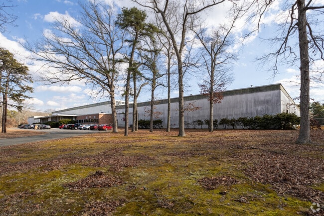
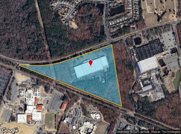
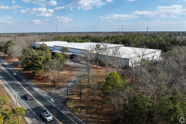
5176 Harding Hwy, Mays Landing, NJ 08330

NEARBY LISTINGS FOR SALE OR LEASE
Property Detail
5176 Harding Hwy
Atlantic City-Hammonton, NJ
ADDITIONAL LOTS: IBPZA
12-01029-0000-00001
Atlantic
Industrialgeneral
New Jersey
X
1
34001C0279F
28.60 AC
2024
Atlantic City/Hammonton
2025
Philadelphia
011404
DEMOGRAPHICS near 5176 Harding Hwy
1 Mile
3 Mile
5 Mile
2024 Total Population
1,647
14,622
33,286
2029 Population
1,608
14,340
32,626
Pop Growth 2024-2029
(2.37%)
(1.93%)
(1.98%)
Average Age
44
40
41
2024 Total Households
602
5,528
12,074
HH Growth 2024-2029
(3.65%)
(2.64%)
(2.61%)
Median Household Inc
$68,113
$73,049
$77,313
Avg Household Size
2.20
2.50
2.60
2024 Avg HH Vehicles
2.00
2.00
2.00
Median Home Value
$262,569
$234,505
$230,343
Median Year Built
1995
1985
1989
Nearby Places
Map Layers
Map Styles
 Street
 Aerial
- Restaurants
- Banks
- Shops
- Fitness
- Groceries
PUBLIC TRANSPORTATION
COMMUTER RAIL
Egg Harbor City (Atlantic City Line - NJ Transit Commuter Rail (NJ Transit))
DRIVE
WALK
Distance
Egg Harbor City (Atlantic City Line - NJ Transit Commuter Rail (NJ Transit))
14 min
8.8 mi
AIRPORT
Atlantic City International
DRIVE
WALK
Distance
Atlantic City International
33 min
10.2 mi
Freight Ports
Broadway Terminal - Pier 5
DRIVE
WALK
Distance
Broadway Terminal - Pier 5
60 min
47.3 mi
SALE & LEASE HISTORY
LISTING DATE
SALE/LEASE

Sep 24, 2016
For Sale
Oct 16, 2019
For Lease
Oct 04, 2018
For Lease
Dec 02, 2020
For Lease
Aug 14, 2017
For Lease
Nearby Properties
Address
Land Use
TOTAL SIZE
Lot Size
Zoning
Address
Land Use
TOTAL SIZE
Lot Size
Zoning
48.59 AC
IBP
Address
Land Use
TOTAL SIZE
Lot Size
Zoning
78.84 AC
GA-M
Address
Land Use
TOTAL SIZE
Lot Size
Zoning
19.70 AC
IBP
Address
Land Use
TOTAL SIZE
Lot Size
Zoning
360 SF
23.28 AC
GA-I
Address
Land Use
TOTAL SIZE
Lot Size
Zoning
53.17 AC
IBP
Address
Land Use
TOTAL SIZE
Lot Size
Zoning
312.70 AC
GA-M
Address
Land Use
TOTAL SIZE
Lot Size
Zoning
31.17 AC
GA-M
Address
Land Use
TOTAL SIZE
Lot Size
Zoning
28.50 AC
IBP
Address
Land Use
TOTAL SIZE
Lot Size
Zoning
36.97 AC
DC
Address
Land Use
TOTAL SIZE
Lot Size
Zoning
75,248 SF
20.85 AC
IBP
Address
Land Use
TOTAL SIZE
Lot Size
Zoning
11,572 SF
19.68 AC
DC
Address
Land Use
TOTAL SIZE
Lot Size
Zoning
45.45 AC
IBP
Address
Land Use
TOTAL SIZE
Lot Size
Zoning
10.83 AC
DC
Address
Land Use
TOTAL SIZE
Lot Size
Zoning
13.50 AC
GA-I
Address
Land Use
TOTAL SIZE
Lot Size
Zoning
10.30 AC
GA-I
Address
Land Use
TOTAL SIZE
Lot Size
Zoning
11.60 AC
GA-I
Address
Land Use
TOTAL SIZE
Lot Size
Zoning
71,556 SF
7.13 AC
R-9
Address
Land Use
TOTAL SIZE
Lot Size
Zoning
13,845 SF
18.28 AC
PVD
Address
Land Use
TOTAL SIZE
Lot Size
Zoning
22,723 SF
16.53 AC
IBP
Address
Land Use
TOTAL SIZE
Lot Size
Zoning
3,138 SF
12.26 AC
RD-5
Address
Land Use
TOTAL SIZE
Lot Size
Zoning
59,354 SF
5.29 AC
IBP
Address
Land Use
TOTAL SIZE
Lot Size
Zoning
14.08 AC
DC
Address
Land Use
TOTAL SIZE
Lot Size
Zoning
5.95 AC
DC
Address
Land Use
TOTAL SIZE
Lot Size
Zoning
45.07 AC
DC
Address
Land Use
TOTAL SIZE
Lot Size
Zoning
90,000 SF
5.64 AC
IBP
Address
Land Use
TOTAL SIZE
Lot Size
Zoning
12.54 AC
DC
Address
Land Use
TOTAL SIZE
Lot Size
Zoning
255.95 AC
RC
Address
Land Use
TOTAL SIZE
Lot Size
Zoning
19,543 SF
115.47 AC
GA-I
Address
Land Use
TOTAL SIZE
Lot Size
Zoning
59,362 SF
3.47 AC
R-9
Address
Land Use
TOTAL SIZE
Lot Size
Zoning
10,204 SF
4.82 AC
GA-L
The World's #1 Commercial Real Estate Marketplace
Connect with us
© 2025 CoStar Group
The information above has been obtained from sources believed reliable. While we do not doubt its accuracy we have not verified it and make no guarantee, warranty or representation about it. It is your responsibility to independently confirm its accuracy and completeness. Any projections, opinions, assumptions, or estimates used are for example only and do not represent the current or future performance of the property. The value of this transaction to you depends on tax and other factors which should be evaluated by your tax, financial, and legal advisors. You and your advisors should conduct a careful, independent investigation of the property to determine to your satisfaction the suitability of the property for your needs.