Property Record
518 Bell Ave, Ames, IA 50010

Save to a Folder
{{folder.Name}}
{{folder.ListingIds.length}} Properties
{{folder.ListingIds.length}} Property
Create a New Folder
Property Detail
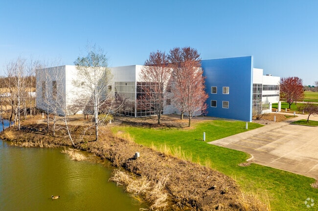
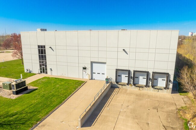
518 Bell Ave
10-07-175-040
AMES COMM DEVEL PARK 2ND ADD LOT:5 AMES
Coldstorage
STORY
GI
Iowa
B and X Area of moderate flood hazard, usually the area between the limits of the 100-year and 500-year floods.
5
2025
11.05 AC
2025
East Ames
000900
Other Market Areas
46,460 SF
Ames, IA
NEARBY LISTINGS FOR SALE OR LEASE
DEMOGRAPHICS near 518 Bell Ave
1 mile
3 mile
5 mile
2025 Total Population
524
15,669
55,927
2030 Population
530
15,976
57,028
Pop Growth 2025-2030
+ 1.15%
+ 1.96%
+ 1.97%
Average Age
42
35
33
2025 Total Households
208
7,486
20,437
HH Growth 2025-2030
+ 1.44%
+ 2.10%
+ 2.59%
Median Household Inc
$84,375
$62,649
$60,131
Avg Household Size
2.50
2.00
2.10
2025 Avg HH Vehicles
2.00
2.00
2.00
Median Home Value
$184,374
$227,694
$282,698
Median Year Built
1976
1973
1986
Nearby Places
Map Layers
Map Styles
 Street
 Aerial
Layers
 Traffic
 Biking
Places
Listings with unknown addresses are not visible on the map
- Restaurants
- Banks
- Shops
- Fitness
- Groceries
Nearby Properties
Address
Land Use
TOTAL SIZE
Lot Size
Zoning
Address
Land Use
TOTAL SIZE
Lot Size
Zoning
2,400 SF
146.13 AC
PI
Address
Land Use
TOTAL SIZE
Lot Size
Zoning
54,112 SF
12.70 AC
Address
Land Use
TOTAL SIZE
Lot Size
Zoning
160,350 SF
55.85 AC
Address
Land Use
TOTAL SIZE
Lot Size
Zoning
576,476 SF
23.76 AC
GI
Address
Land Use
TOTAL SIZE
Lot Size
Zoning
188,204 SF
70.81 AC
A1
Address
Land Use
TOTAL SIZE
Lot Size
Zoning
215,689 SF
22.56 AC
HOC
Address
Land Use
TOTAL SIZE
Lot Size
Zoning
75,302 SF
16.66 AC
HOC
Address
Land Use
TOTAL SIZE
Lot Size
Zoning
177,201 SF
26.29 AC
Address
Land Use
TOTAL SIZE
Lot Size
Zoning
3,500 SF
56.27 AC
GI
Address
Land Use
TOTAL SIZE
Lot Size
Zoning
262,786 SF
16.05 AC
GI
Address
Land Use
TOTAL SIZE
Lot Size
Zoning
78,379 SF
7.92 AC
SHM
Address
Land Use
TOTAL SIZE
Lot Size
Zoning
384 SF
62.77 AC
GI
Address
Land Use
TOTAL SIZE
Lot Size
Zoning
171,800 SF
19.34 AC
PI
Address
Land Use
TOTAL SIZE
Lot Size
Zoning
115,338 SF
16.41 AC
HOC
Address
Land Use
TOTAL SIZE
Lot Size
Zoning
122,502 SF
10.96 AC
HOC
Address
Land Use
TOTAL SIZE
Lot Size
Zoning
114,744 SF
14.35 AC
HOC
Address
Land Use
TOTAL SIZE
Lot Size
Zoning
75,122 SF
3.79 AC
HOC
Address
Land Use
TOTAL SIZE
Lot Size
Zoning
32,383 SF
8.36 AC
Address
Land Use
TOTAL SIZE
Lot Size
Zoning
24,274 SF
10.39 AC
Address
Land Use
TOTAL SIZE
Lot Size
Zoning
7,200 SF
4.32 AC
HOC
Address
Land Use
TOTAL SIZE
Lot Size
Zoning
99,962 SF
4.58 AC
Address
Land Use
TOTAL SIZE
Lot Size
Zoning
14,837 SF
8 AC
GI
Address
Land Use
TOTAL SIZE
Lot Size
Zoning
88,628 SF
10.01 AC
HOC
Address
Land Use
TOTAL SIZE
Lot Size
Zoning
67,700 SF
3.07 AC
Address
Land Use
TOTAL SIZE
Lot Size
Zoning
63,136 SF
2.96 AC
Address
Land Use
TOTAL SIZE
Lot Size
Zoning
3,150 SF
26.50 AC
GI
Address
Land Use
TOTAL SIZE
Lot Size
Zoning
58,109 SF
7.25 AC
Address
Land Use
TOTAL SIZE
Lot Size
Zoning
20,000 SF
7 AC
HOC
Address
Land Use
TOTAL SIZE
Lot Size
Zoning
13,287 SF
32.50 AC
Address
Land Use
TOTAL SIZE
Lot Size
Zoning
38,939 SF
3.63 AC
CCN
The World's #1 Commercial Real Estate Marketplace
Connect with us
© 2026 CoStar Group
The information above has been obtained from sources believed reliable. While we do not doubt its accuracy we have not verified it and make no guarantee, warranty or representation about it. It is your responsibility to independently confirm its accuracy and completeness. Any projections, opinions, assumptions, or estimates used are for example only and do not represent the current or future performance of the property. The value of this transaction to you depends on tax and other factors which should be evaluated by your tax, financial, and legal advisors. You and your advisors should conduct a careful, independent investigation of the property to determine to your satisfaction the suitability of the property for your needs.