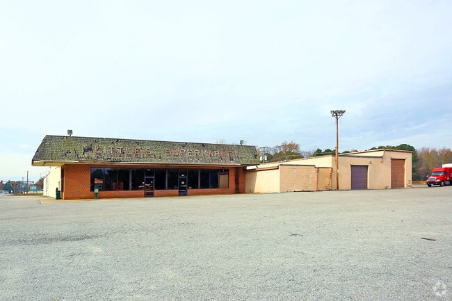
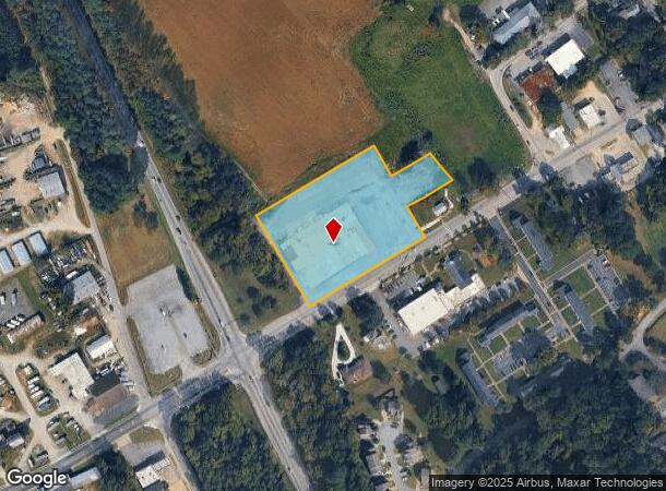
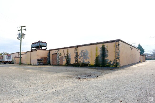
Property Record
518 Main St, Smithfield, VA 23430
NEARBY LISTINGS FOR SALE OR LEASE
Property Detail
518 Main St
21A-04-000I15
Nancy T Little
Commercialacreage
PCL I15 ADJ JACK LITTLE PLAT 2-145-17
X
Isle of Wight
51093C0135E
Virginia
2025
2.99 AC
2025
Smithfield
280105
Hampton Roads
34,970 SF
Virginia Beach-Norfolk-Newport News, VA-NC
DEMOGRAPHICS near 518 Main St
1 Mile
3 Mile
5 Mile
2024 Total Population
2,099
11,128
18,022
2029 Population
2,315
12,175
19,697
Pop Growth 2024-2029
+ 10.29%
+ 9.41%
+ 9.29%
Average Age
43
43
43
2024 Total Households
927
4,405
7,098
HH Growth 2024-2029
+ 10.14%
+ 9.35%
+ 9.20%
Median Household Inc
$35,704
$82,557
$92,903
Avg Household Size
2.30
2.50
2.50
2024 Avg HH Vehicles
1.00
2.00
2.00
Median Home Value
$289,669
$322,602
$340,575
Median Year Built
1976
1988
1991
Nearby Places
Map Layers
Map Styles
 Street
 Aerial
- Restaurants
- Banks
- Shops
- Fitness
- Groceries
PUBLIC TRANSPORTATION
AIRPORT
Newport News/Williamsburg International
DRIVE
WALK
Distance
Newport News/Williamsburg International
41 min
24.1 mi
Norfolk International
DRIVE
WALK
Distance
Norfolk International
53 min
31.9 mi
Freight Ports
Virginia Port Authority - Newport News
DRIVE
WALK
Distance
Virginia Port Authority - Newport News
28 min
17.5 mi
SALE & LEASE HISTORY
LISTING DATE
SALE/LEASE

Sep 23, 2016
For Sale
Sep 02, 2020
For Sale
Nearby Properties
Address
Land Use
TOTAL SIZE
Lot Size
Zoning
Address
Land Use
TOTAL SIZE
Lot Size
Zoning
111,208 SF
20.01 AC
RAC
Address
Land Use
TOTAL SIZE
Lot Size
Zoning
24.09 AC
TOWN
Address
Land Use
TOTAL SIZE
Lot Size
Zoning
35,102 SF
0.86 AC
TOWN
Address
Land Use
TOTAL SIZE
Lot Size
Zoning
33,611 SF
1.17 AC
TOWN
Address
Land Use
TOTAL SIZE
Lot Size
Zoning
21.42 AC
TOWN
Address
Land Use
TOTAL SIZE
Lot Size
Zoning
8.50 AC
02
Address
Land Use
TOTAL SIZE
Lot Size
Zoning
64,187 SF
13.11 AC
TOWN
Address
Land Use
TOTAL SIZE
Lot Size
Zoning
52,944 SF
9.67 AC
TOWN
Address
Land Use
TOTAL SIZE
Lot Size
Zoning
3,500 SF
16.98 AC
TOWN
Address
Land Use
TOTAL SIZE
Lot Size
Zoning
58,368 SF
2.51 AC
TOWN
Address
Land Use
TOTAL SIZE
Lot Size
Zoning
13,512 SF
8.07 AC
TOWN
Address
Land Use
TOTAL SIZE
Lot Size
Zoning
15,600 SF
5.09 AC
TOWN
Address
Land Use
TOTAL SIZE
Lot Size
Zoning
10,524 SF
3.87 AC
TOWN
Address
Land Use
TOTAL SIZE
Lot Size
Zoning
16,720 SF
0.39 AC
TOWN
Address
Land Use
TOTAL SIZE
Lot Size
Zoning
28.68 AC
01
Address
Land Use
TOTAL SIZE
Lot Size
Zoning
26,688 SF
0.63 AC
TOWN
Address
Land Use
TOTAL SIZE
Lot Size
Zoning
37,996 SF
8.74 AC
TOWN
Address
Land Use
TOTAL SIZE
Lot Size
Zoning
31,802 SF
5.22 AC
TOWN
Address
Land Use
TOTAL SIZE
Lot Size
Zoning
45,170 SF
3.05 AC
TOWN
Address
Land Use
TOTAL SIZE
Lot Size
Zoning
19,120 SF
3.65 AC
TOWN
Address
Land Use
TOTAL SIZE
Lot Size
Zoning
30,162 SF
0.30 AC
TOWN
Address
Land Use
TOTAL SIZE
Lot Size
Zoning
7,127 SF
22.64 AC
TOWN
Address
Land Use
TOTAL SIZE
Lot Size
Zoning
13,460 SF
3.47 AC
TOWN
Address
Land Use
TOTAL SIZE
Lot Size
Zoning
14,790 SF
3.28 AC
TOWN
Address
Land Use
TOTAL SIZE
Lot Size
Zoning
92,368 SF
4.82 AC
TOWN
Address
Land Use
TOTAL SIZE
Lot Size
Zoning
14,306 SF
3.62 AC
TOWN
Address
Land Use
TOTAL SIZE
Lot Size
Zoning
16,963 SF
2.36 AC
TOWN
Address
Land Use
TOTAL SIZE
Lot Size
Zoning
13,512 SF
9.75 AC
TOWN
Address
Land Use
TOTAL SIZE
Lot Size
Zoning
5,040 SF
5.97 AC
TOWN
Address
Land Use
TOTAL SIZE
Lot Size
Zoning
150.60 AC
TOWN
The World's #1 Commercial Real Estate Marketplace
Connect with us
© 2026 CoStar Group
The information above has been obtained from sources believed reliable. While we do not doubt its accuracy we have not verified it and make no guarantee, warranty or representation about it. It is your responsibility to independently confirm its accuracy and completeness. Any projections, opinions, assumptions, or estimates used are for example only and do not represent the current or future performance of the property. The value of this transaction to you depends on tax and other factors which should be evaluated by your tax, financial, and legal advisors. You and your advisors should conduct a careful, independent investigation of the property to determine to your satisfaction the suitability of the property for your needs.