Property Record
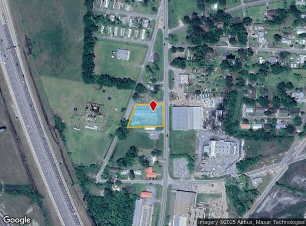
518 S Elm St, Adel, GA 31620
NEARBY LISTINGS FOR SALE OR LEASE
-
-
View all Adel listings for sale on LoopNet.com
Property Detail
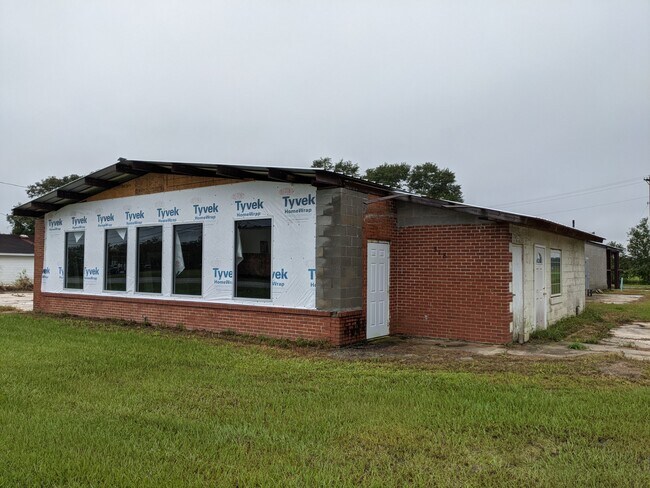
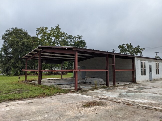
518 S Elm St
Daycare
LL 361-8-3 FERTILIZER WAREHOUSE
X
Cook
13075C0120D
Georgia
2024
0.63 AC
2024
Valdosta/Lake Park
960200
Other Market Areas
5,984 SF
A004-001
DEMOGRAPHICS near 518 S Elm St
1 Mile
3 Mile
5 Mile
2024 Total Population
2,468
8,288
11,715
2029 Population
2,559
8,508
12,028
Pop Growth 2024-2029
+ 3.69%
+ 2.65%
+ 2.67%
Average Age
38
39
39
2024 Total Households
958
3,127
4,358
HH Growth 2024-2029
+ 3.65%
+ 2.59%
+ 2.62%
Median Household Inc
$30,028
$34,971
$45,250
Avg Household Size
2.50
2.60
2.60
2024 Avg HH Vehicles
2.00
2.00
2.00
Median Home Value
$76,197
$127,664
$137,067
Median Year Built
1974
1983
1987
Nearby Places
Map Layers
Map Styles
 Street
 Aerial
- Restaurants
- Banks
- Shops
- Fitness
- Groceries
PUBLIC TRANSPORTATION
AIRPORT
Valdosta Regional
DRIVE
WALK
Distance
Valdosta Regional
36 min
29.2 mi
Freight Ports
Georgia Ports - Brunswick
DRIVE
WALK
Distance
Georgia Ports - Brunswick
170 min
129.0 mi
SALE & LEASE HISTORY
LISTING DATE
SALE/LEASE

Sep 23, 2021
For Sale
Nearby Properties
Address
Land Use
TOTAL SIZE
Lot Size
Zoning
Address
Land Use
TOTAL SIZE
Lot Size
Zoning
391,614 SF
160.24 AC
HI
Address
Land Use
TOTAL SIZE
Lot Size
Zoning
19,129 SF
93.78 AC
B1
Address
Land Use
TOTAL SIZE
Lot Size
Zoning
125,719 SF
10.16 AC
Address
Land Use
TOTAL SIZE
Lot Size
Zoning
11,604 SF
7.43 AC
R10
Address
Land Use
TOTAL SIZE
Lot Size
Zoning
27,830 SF
48.14 AC
B1
Address
Land Use
TOTAL SIZE
Lot Size
Zoning
4,000 SF
265.82 AC
WLI
Address
Land Use
TOTAL SIZE
Lot Size
Zoning
25,346 SF
11.65 AC
WLI
Address
Land Use
TOTAL SIZE
Lot Size
Zoning
46,102 SF
3.67 AC
RP
Address
Land Use
TOTAL SIZE
Lot Size
Zoning
8,188 SF
1.08 AC
RP
Address
Land Use
TOTAL SIZE
Lot Size
Zoning
60,000 SF
20.82 AC
HI
Address
Land Use
TOTAL SIZE
Lot Size
Zoning
56,952 SF
16.42 AC
HI
Address
Land Use
TOTAL SIZE
Lot Size
Zoning
20,100 SF
5.41 AC
RP
Address
Land Use
TOTAL SIZE
Lot Size
Zoning
5,440 SF
6.48 AC
R8
Address
Land Use
TOTAL SIZE
Lot Size
Zoning
2,718 SF
62.71 AC
GB
Address
Land Use
TOTAL SIZE
Lot Size
Zoning
197,890 SF
55.63 AC
WLI
Address
Land Use
TOTAL SIZE
Lot Size
Zoning
25,894 SF
2.89 AC
GB
Address
Land Use
TOTAL SIZE
Lot Size
Zoning
1,850 SF
71.40 AC
GB
Address
Land Use
TOTAL SIZE
Lot Size
Zoning
10,475 SF
4.65 AC
R10
Address
Land Use
TOTAL SIZE
Lot Size
Zoning
7,828 SF
8.23 AC
HI
Address
Land Use
TOTAL SIZE
Lot Size
Zoning
35,550 SF
6.20 AC
GB
Address
Land Use
TOTAL SIZE
Lot Size
Zoning
19,827 SF
0.80 AC
GB
Address
Land Use
TOTAL SIZE
Lot Size
Zoning
6,985 SF
31.29 AC
HI
Address
Land Use
TOTAL SIZE
Lot Size
Zoning
41,132 SF
8.59 AC
HI
Address
Land Use
TOTAL SIZE
Lot Size
Zoning
25,902 SF
2.79 AC
RP
Address
Land Use
TOTAL SIZE
Lot Size
Zoning
4,420 SF
0.90 AC
RP
Address
Land Use
TOTAL SIZE
Lot Size
Zoning
34,503 SF
3.86 AC
GB
Address
Land Use
TOTAL SIZE
Lot Size
Zoning
9,441 SF
4.95 AC
B1
Address
Land Use
TOTAL SIZE
Lot Size
Zoning
77,875 SF
40.52 AC
HI
Address
Land Use
TOTAL SIZE
Lot Size
Zoning
10,349 SF
2.36 AC
GB
The World's #1 Commercial Real Estate Marketplace
Connect with us
© 2025 CoStar Group
The information above has been obtained from sources believed reliable. While we do not doubt its accuracy we have not verified it and make no guarantee, warranty or representation about it. It is your responsibility to independently confirm its accuracy and completeness. Any projections, opinions, assumptions, or estimates used are for example only and do not represent the current or future performance of the property. The value of this transaction to you depends on tax and other factors which should be evaluated by your tax, financial, and legal advisors. You and your advisors should conduct a careful, independent investigation of the property to determine to your satisfaction the suitability of the property for your needs.