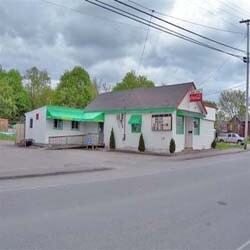
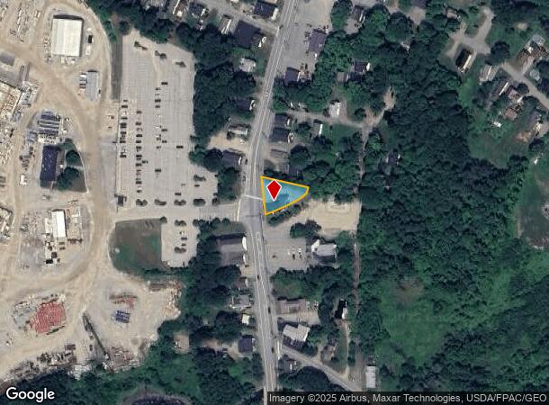
Property Record
518 S Main St, Brewer, ME 04412
NEARBY LISTINGS FOR SALE OR LEASE
Property Detail
518 S Main St
BRER-000022-000000-000018
Penobscot
Restaurantbuilding
Maine
X
18
23019C2119D
0.27 AC
2024
Maine North & Bangor
2024
Other Market Areas
004100
Bangor, ME
1,914 SF
DEMOGRAPHICS near 518 S Main St
1 Mile
3 Mile
5 Mile
2024 Total Population
3,428
28,800
48,055
2029 Population
3,496
29,469
49,270
Pop Growth 2024-2029
+ 1.98%
+ 2.32%
+ 2.53%
Average Age
44
43
43
2024 Total Households
1,503
13,589
21,772
HH Growth 2024-2029
+ 2.00%
+ 2.47%
+ 2.67%
Median Household Inc
$59,968
$50,344
$55,829
Avg Household Size
2.20
2.00
2.10
2024 Avg HH Vehicles
2.00
1.00
2.00
Median Home Value
$201,459
$196,172
$213,192
Median Year Built
1963
1952
1966
Nearby Places
Map Layers
Map Styles
 Street
 Aerial
- Restaurants
- Banks
- Shops
- Fitness
- Groceries
PUBLIC TRANSPORTATION
AIRPORT
Bangor International
DRIVE
WALK
Distance
Bangor International
11 min
5.8 mi
Freight Ports
Searsport, ME
DRIVE
WALK
Distance
Searsport, ME
44 min
28.3 mi
Nearby Properties
Address
Land Use
TOTAL SIZE
Lot Size
Zoning
Address
Land Use
TOTAL SIZE
Lot Size
Zoning
186,220 SF
93.91 AC
G&SD
Address
Land Use
TOTAL SIZE
Lot Size
Zoning
609,180 SF
6.68 AC
USD
Address
Land Use
TOTAL SIZE
Lot Size
Zoning
Address
Land Use
TOTAL SIZE
Lot Size
Zoning
Address
Land Use
TOTAL SIZE
Lot Size
Zoning
6.37 AC
UID
Address
Land Use
TOTAL SIZE
Lot Size
Zoning
243,694 SF
2.95 AC
G&ISD
Address
Land Use
TOTAL SIZE
Lot Size
Zoning
146,924 SF
2.62 AC
G&ISD
Address
Land Use
TOTAL SIZE
Lot Size
Zoning
400 SF
3.44 AC
WDD
Address
Land Use
TOTAL SIZE
Lot Size
Zoning
100,800 SF
1.34 AC
DDD
Address
Land Use
TOTAL SIZE
Lot Size
Zoning
12,950 SF
23.39 AC
31 - I
Address
Land Use
TOTAL SIZE
Lot Size
Zoning
168,615 SF
19.44 AC
MDR-1
Address
Land Use
TOTAL SIZE
Lot Size
Zoning
38 AC
G&ISD
Address
Land Use
TOTAL SIZE
Lot Size
Zoning
115,044 SF
13.30 AC
G&ISD
Address
Land Use
TOTAL SIZE
Lot Size
Zoning
184,000 SF
16.43 AC
31 - I
Address
Land Use
TOTAL SIZE
Lot Size
Zoning
110,031 SF
3.81 AC
GC&S
Address
Land Use
TOTAL SIZE
Lot Size
Zoning
68,708 SF
7.85 AC
PB
Address
Land Use
TOTAL SIZE
Lot Size
Zoning
34.50 AC
Address
Land Use
TOTAL SIZE
Lot Size
Zoning
Address
Land Use
TOTAL SIZE
Lot Size
Zoning
144,000 SF
111.04 AC
32 - I
Address
Land Use
TOTAL SIZE
Lot Size
Zoning
109,507 SF
1.96 AC
G&ISD
Address
Land Use
TOTAL SIZE
Lot Size
Zoning
7 AC
WDD
Address
Land Use
TOTAL SIZE
Lot Size
Zoning
161,540 SF
23.68 AC
GB
Address
Land Use
TOTAL SIZE
Lot Size
Zoning
139,863 SF
20.68 AC
GB
Address
Land Use
TOTAL SIZE
Lot Size
Zoning
83,231 SF
15.88 AC
HDR-2
Address
Land Use
TOTAL SIZE
Lot Size
Zoning
32,570 SF
1.38 AC
G&ISD
Address
Land Use
TOTAL SIZE
Lot Size
Zoning
69,703 SF
7.92 AC
USD
Address
Land Use
TOTAL SIZE
Lot Size
Zoning
28.15 AC
GB
Address
Land Use
TOTAL SIZE
Lot Size
Zoning
96,178 SF
10.63 AC
GB
Address
Land Use
TOTAL SIZE
Lot Size
Zoning
16.63 AC
GB
Address
Land Use
TOTAL SIZE
Lot Size
Zoning
55,514 SF
1.86 AC
G&ISD
The World's #1 Commercial Real Estate Marketplace
Connect with us
© 2026 CoStar Group
The information above has been obtained from sources believed reliable. While we do not doubt its accuracy we have not verified it and make no guarantee, warranty or representation about it. It is your responsibility to independently confirm its accuracy and completeness. Any projections, opinions, assumptions, or estimates used are for example only and do not represent the current or future performance of the property. The value of this transaction to you depends on tax and other factors which should be evaluated by your tax, financial, and legal advisors. You and your advisors should conduct a careful, independent investigation of the property to determine to your satisfaction the suitability of the property for your needs.