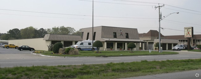
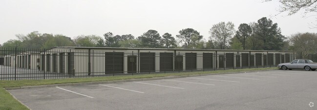
Property Record
5185 Shore Dr, Virginia Beach, VA 23455

NEARBY LISTINGS FOR SALE OR LEASE
-
-
View all Virginia Beach listings for sale on LoopNet.com
Property Detail
5185 Shore Dr
1479-07-2544
Subd Prop John W Smith
Shipyard
SUBD PROP JOHN W SMITH PARCEL A 4.635 ACRES
AE
Virginia Beach
5155310019G
Virginia
2024
4.64 AC
2025
Airport/Northampton
041200
Hampton Roads
93,075 SF
Virginia Beach-Chesapeake-Norfolk, VA-NC
DEMOGRAPHICS near 5185 Shore Dr
1 Mile
3 Mile
5 Mile
2024 Total Population
9,311
56,708
161,851
2029 Population
9,251
56,367
160,205
Pop Growth 2024-2029
(0.64%)
(0.60%)
(1.02%)
Average Age
33
40
39
2024 Total Households
3,158
23,569
66,918
HH Growth 2024-2029
(0.89%)
(0.74%)
(1.18%)
Median Household Inc
$66,123
$76,687
$71,039
Avg Household Size
2.60
2.30
2.30
2024 Avg HH Vehicles
2.00
2.00
2.00
Median Home Value
$371,808
$381,027
$301,478
Median Year Built
1974
1982
1977
Nearby Places
Map Layers
Map Styles
 Street
 Aerial
- Restaurants
- Banks
- Shops
- Fitness
- Groceries
PUBLIC TRANSPORTATION
COMMUTER RAIL
Norfolk (Northeast Regional - Amtrak)
DRIVE
WALK
Distance
Norfolk (Northeast Regional - Amtrak)
17 min
9.5 mi
AIRPORT
Norfolk International
DRIVE
WALK
Distance
Norfolk International
14 min
6.6 mi
Newport News/Williamsburg International
DRIVE
WALK
Distance
Newport News/Williamsburg International
44 min
29.5 mi
Freight Ports
Virginia Port Authority - Norfolk
DRIVE
WALK
Distance
Virginia Port Authority - Norfolk
23 min
11.5 mi
Nearby Properties
Address
Land Use
TOTAL SIZE
Lot Size
Zoning
Address
Land Use
TOTAL SIZE
Lot Size
Zoning
10 SF
207.44 AC
I2
Address
Land Use
TOTAL SIZE
Lot Size
Zoning
116,476 SF
947.43 AC
Address
Land Use
TOTAL SIZE
Lot Size
Zoning
1,802 SF
14.40 AC
A24
Address
Land Use
TOTAL SIZE
Lot Size
Zoning
15.12 AC
Address
Land Use
TOTAL SIZE
Lot Size
Zoning
434,920 SF
8.35 AC
A36
Address
Land Use
TOTAL SIZE
Lot Size
Zoning
226,775 SF
13.14 AC
B2
Address
Land Use
TOTAL SIZE
Lot Size
Zoning
1 SF
17.15 AC
A24
Address
Land Use
TOTAL SIZE
Lot Size
Zoning
6,572 SF
23.41 AC
Address
Land Use
TOTAL SIZE
Lot Size
Zoning
Address
Land Use
TOTAL SIZE
Lot Size
Zoning
318,496 SF
13.79 AC
A18
Address
Land Use
TOTAL SIZE
Lot Size
Zoning
100,550 SF
1.72 AC
Address
Land Use
TOTAL SIZE
Lot Size
Zoning
1,980 SF
1.87 AC
Address
Land Use
TOTAL SIZE
Lot Size
Zoning
1 SF
14.97 AC
A18
Address
Land Use
TOTAL SIZE
Lot Size
Zoning
179,912 SF
9.08 AC
A36
Address
Land Use
TOTAL SIZE
Lot Size
Zoning
180,023 SF
16.84 AC
B2
Address
Land Use
TOTAL SIZE
Lot Size
Zoning
1 SF
10.60 AC
A18
Address
Land Use
TOTAL SIZE
Lot Size
Zoning
2 SF
12.79 AC
A18
Address
Land Use
TOTAL SIZE
Lot Size
Zoning
40,323 SF
2.60 AC
Address
Land Use
TOTAL SIZE
Lot Size
Zoning
1 SF
0.01 AC
A24
Address
Land Use
TOTAL SIZE
Lot Size
Zoning
71,160 SF
0.01 AC
R15
Address
Land Use
TOTAL SIZE
Lot Size
Zoning
106,600 SF
2.81 AC
Address
Land Use
TOTAL SIZE
Lot Size
Zoning
168,605 SF
13.32 AC
I1
Address
Land Use
TOTAL SIZE
Lot Size
Zoning
1 SF
12.13 AC
A18
Address
Land Use
TOTAL SIZE
Lot Size
Zoning
96,251 SF
15.04 AC
R75
Address
Land Use
TOTAL SIZE
Lot Size
Zoning
322,404 SF
18.39 AC
I1
Address
Land Use
TOTAL SIZE
Lot Size
Zoning
77,338 SF
11.12 AC
R75
Address
Land Use
TOTAL SIZE
Lot Size
Zoning
205,006 SF
12.94 AC
O2
Address
Land Use
TOTAL SIZE
Lot Size
Zoning
194,728 SF
25.75 AC
R75
Address
Land Use
TOTAL SIZE
Lot Size
Zoning
124,314 SF
7.29 AC
A18
Address
Land Use
TOTAL SIZE
Lot Size
Zoning
85,607 SF
18.48 AC
R10
The World's #1 Commercial Real Estate Marketplace
Connect with us
© 2026 CoStar Group
The information above has been obtained from sources believed reliable. While we do not doubt its accuracy we have not verified it and make no guarantee, warranty or representation about it. It is your responsibility to independently confirm its accuracy and completeness. Any projections, opinions, assumptions, or estimates used are for example only and do not represent the current or future performance of the property. The value of this transaction to you depends on tax and other factors which should be evaluated by your tax, financial, and legal advisors. You and your advisors should conduct a careful, independent investigation of the property to determine to your satisfaction the suitability of the property for your needs.