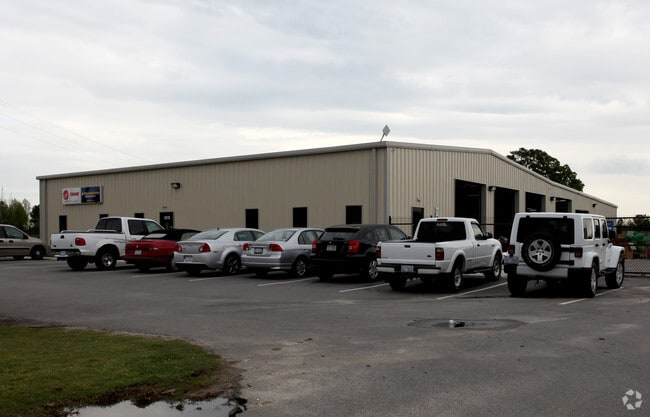
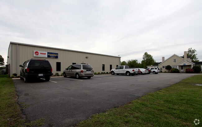
Property Record
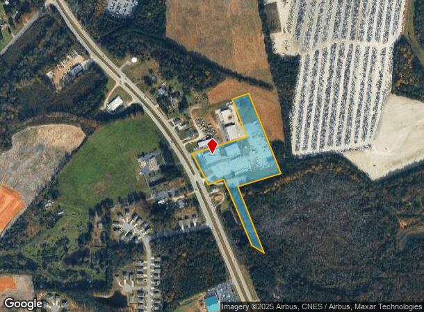
5188 Us 70 Bus Hwy W, Clayton, NC 27520
NEARBY LISTINGS FOR SALE OR LEASE
Property Detail
5188 Us 70 Bus Hwy W
05G01200T
Recombination Plat For Charles Phillip T
Multipleuses
TYLER AND MCFADYEN FAMILY TRUST 78/464
X
Johnston
3720167600K
North Carolina
2025
8.58 AC
2025
Johnston County
041104
Raleigh/Durham
10,080 SF
Raleigh, NC
DEMOGRAPHICS near 5188 Us 70 Bus Hwy W
1 Mile
3 Mile
5 Mile
2024 Total Population
550
12,677
46,274
2029 Population
668
15,414
56,463
Pop Growth 2024-2029
+ 21.45%
+ 21.59%
+ 22.02%
Average Age
40
39
38
2024 Total Households
193
4,277
16,077
HH Growth 2024-2029
+ 21.76%
+ 21.70%
+ 22.12%
Median Household Inc
$84,879
$77,510
$74,325
Avg Household Size
2.70
2.80
2.80
2024 Avg HH Vehicles
2.00
2.00
2.00
Median Home Value
$232,456
$255,167
$268,908
Median Year Built
1993
2001
2002
Nearby Places
Map Layers
Map Styles
 Street
 Aerial
- Restaurants
- Banks
- Shops
- Fitness
- Groceries
PUBLIC TRANSPORTATION
AIRPORT
Raleigh-Durham International
DRIVE
WALK
Distance
Raleigh-Durham International
48 min
37.8 mi
Nearby Properties
Address
Land Use
TOTAL SIZE
Lot Size
Zoning
Address
Land Use
TOTAL SIZE
Lot Size
Zoning
29,088 SF
193.04 AC
IND
Address
Land Use
TOTAL SIZE
Lot Size
Zoning
71,773 SF
54.30 AC
IND
Address
Land Use
TOTAL SIZE
Lot Size
Zoning
25,200 SF
IND
Address
Land Use
TOTAL SIZE
Lot Size
Zoning
50,490 SF
IND
Address
Land Use
TOTAL SIZE
Lot Size
Zoning
99,977 SF
65.35 AC
IND
Address
Land Use
TOTAL SIZE
Lot Size
Zoning
84,568 SF
COM
Address
Land Use
TOTAL SIZE
Lot Size
Zoning
14,748 SF
114.84 AC
IND
Address
Land Use
TOTAL SIZE
Lot Size
Zoning
64,644 SF
IND
Address
Land Use
TOTAL SIZE
Lot Size
Zoning
70,104 SF
47.87 AC
MUP
Address
Land Use
TOTAL SIZE
Lot Size
Zoning
2,217 SF
170.07 AC
IND
Address
Land Use
TOTAL SIZE
Lot Size
Zoning
17,000 SF
67.54 AC
RAG
Address
Land Use
TOTAL SIZE
Lot Size
Zoning
173,567 SF
16.12 AC
IND
Address
Land Use
TOTAL SIZE
Lot Size
Zoning
85,840 SF
13.85 AC
IND
Address
Land Use
TOTAL SIZE
Lot Size
Zoning
11,000 SF
30.80 AC
IND
Address
Land Use
TOTAL SIZE
Lot Size
Zoning
86,155 SF
12.52 AC
IND
Address
Land Use
TOTAL SIZE
Lot Size
Zoning
95,394 SF
97.56 AC
IND
Address
Land Use
TOTAL SIZE
Lot Size
Zoning
10,728 SF
15.09 AC
RAG
Address
Land Use
TOTAL SIZE
Lot Size
Zoning
17,600 SF
RAG
Address
Land Use
TOTAL SIZE
Lot Size
Zoning
24,375 SF
6.55 AC
IND
Address
Land Use
TOTAL SIZE
Lot Size
Zoning
90,910 SF
10.33 AC
IND
Address
Land Use
TOTAL SIZE
Lot Size
Zoning
11,666 SF
15.29 AC
COM
Address
Land Use
TOTAL SIZE
Lot Size
Zoning
31,452 SF
8.01 AC
IND
Address
Land Use
TOTAL SIZE
Lot Size
Zoning
69,115 SF
4.87 AC
IND
Address
Land Use
TOTAL SIZE
Lot Size
Zoning
41,632 SF
3.54 AC
IND
Address
Land Use
TOTAL SIZE
Lot Size
Zoning
40,360 SF
11.57 AC
RES
Address
Land Use
TOTAL SIZE
Lot Size
Zoning
69,072 SF
9.04 AC
IND
Address
Land Use
TOTAL SIZE
Lot Size
Zoning
32,500 SF
20.34 AC
IND
Address
Land Use
TOTAL SIZE
Lot Size
Zoning
35,000 SF
3.36 AC
IND
Address
Land Use
TOTAL SIZE
Lot Size
Zoning
25,580 SF
4.50 AC
IND
Address
Land Use
TOTAL SIZE
Lot Size
Zoning
3,750 SF
22.02 AC
IND
The World's #1 Commercial Real Estate Marketplace
Connect with us
© 2026 CoStar Group
The information above has been obtained from sources believed reliable. While we do not doubt its accuracy we have not verified it and make no guarantee, warranty or representation about it. It is your responsibility to independently confirm its accuracy and completeness. Any projections, opinions, assumptions, or estimates used are for example only and do not represent the current or future performance of the property. The value of this transaction to you depends on tax and other factors which should be evaluated by your tax, financial, and legal advisors. You and your advisors should conduct a careful, independent investigation of the property to determine to your satisfaction the suitability of the property for your needs.