Property Record
5189 State Highway 77, Marion, AR 72364
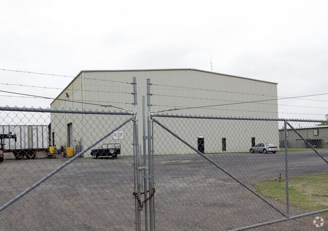

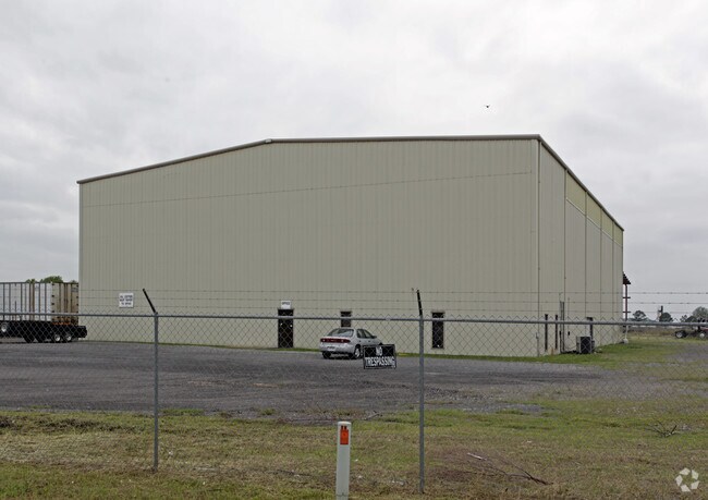
Property Detail
5189 State Highway 77
Memphis, TN-MS-AR
ALL ADDITION PLAT BK 4 PG 89
201-074000-000
Crittenden
Autorepair
Arkansas
C and X Area of minimal flood hazard, usually depicted on FIRMs as above the 500-year flood level.
all
2025
7.70 AC
2025
Crittenden County
030702
Memphis
12,500 SF
NEARBY LISTINGS FOR SALE OR LEASE
DEMOGRAPHICS near 5189 State Highway 77
1 mile
3 mile
5 mile
2025 Total Population
1,020
10,447
15,997
2030 Population
1,013
10,115
15,470
Pop Growth 2025-2030
(0.69%)
(3.18%)
(3.29%)
Average Age
39
38
38
2025 Total Households
372
3,896
6,008
HH Growth 2025-2030
(0.54%)
(3.29%)
(3.41%)
Median Household Inc
$86,842
$72,931
$73,630
Avg Household Size
2.70
2.60
2.60
2025 Avg HH Vehicles
2.00
2.00
2.00
Median Home Value
$265,833
$230,135
$222,082
Median Year Built
1996
1994
1994
Nearby Places
Map Layers
Map Styles
 Street
 Aerial
Layers
 Traffic
 Biking
Places
Listings with unknown addresses are not visible on the map
- Restaurants
- Banks
- Shops
- Fitness
- Groceries
PUBLIC TRANSPORTATION
AIRPORT
Memphis International
Drive
Walk
Distance
Memphis International
36 min
23.0 mi
Nearby Properties
Address
Land Use
TOTAL SIZE
Lot Size
Zoning
Address
Land Use
TOTAL SIZE
Lot Size
Zoning
5,772 SF
20 AC
Address
Land Use
TOTAL SIZE
Lot Size
Zoning
3,960 SF
14.54 AC
Address
Land Use
TOTAL SIZE
Lot Size
Zoning
58,365 SF
6.11 AC
Address
Land Use
TOTAL SIZE
Lot Size
Zoning
59,284 SF
2.06 AC
Address
Land Use
TOTAL SIZE
Lot Size
Zoning
50,279 SF
2.20 AC
Address
Land Use
TOTAL SIZE
Lot Size
Zoning
45,016 SF
1.58 AC
Address
Land Use
TOTAL SIZE
Lot Size
Zoning
46,656 SF
1.39 AC
Address
Land Use
TOTAL SIZE
Lot Size
Zoning
7,924 SF
7.66 AC
Address
Land Use
TOTAL SIZE
Lot Size
Zoning
17,814 SF
2 AC
Address
Land Use
TOTAL SIZE
Lot Size
Zoning
29,340 SF
1.01 AC
Address
Land Use
TOTAL SIZE
Lot Size
Zoning
30,804 SF
5.70 AC
Address
Land Use
TOTAL SIZE
Lot Size
Zoning
26,910 SF
3 AC
Address
Land Use
TOTAL SIZE
Lot Size
Zoning
1,803 SF
2 AC
Address
Land Use
TOTAL SIZE
Lot Size
Zoning
9,976 SF
1.80 AC
Address
Land Use
TOTAL SIZE
Lot Size
Zoning
7,380 SF
3.18 AC
Address
Land Use
TOTAL SIZE
Lot Size
Zoning
46,490 SF
6.01 AC
Address
Land Use
TOTAL SIZE
Lot Size
Zoning
41,827 SF
4.50 AC
Address
Land Use
TOTAL SIZE
Lot Size
Zoning
1,320 SF
7.17 AC
Address
Land Use
TOTAL SIZE
Lot Size
Zoning
9,516 SF
118.21 AC
Address
Land Use
TOTAL SIZE
Lot Size
Zoning
8,297 SF
1.70 AC
Address
Land Use
TOTAL SIZE
Lot Size
Zoning
7,924 SF
3.36 AC
Address
Land Use
TOTAL SIZE
Lot Size
Zoning
6,555 SF
2.69 AC
Address
Land Use
TOTAL SIZE
Lot Size
Zoning
8,504 SF
2.59 AC
Address
Land Use
TOTAL SIZE
Lot Size
Zoning
7,480 SF
1.43 AC
Address
Land Use
TOTAL SIZE
Lot Size
Zoning
1,681 SF
2 AC
Address
Land Use
TOTAL SIZE
Lot Size
Zoning
24,323 SF
2.97 AC
Address
Land Use
TOTAL SIZE
Lot Size
Zoning
7,924 SF
1.46 AC
Address
Land Use
TOTAL SIZE
Lot Size
Zoning
2,944 SF
2.10 AC
Address
Land Use
TOTAL SIZE
Lot Size
Zoning
6,738 SF
1.75 AC
Address
Land Use
TOTAL SIZE
Lot Size
Zoning
5,120 SF
1.60 AC
The World's #1 Commercial Real Estate Marketplace
Connect with us
© 2026 CoStar Group
The information above has been obtained from sources believed reliable. While we do not doubt its accuracy we have not verified it and make no guarantee, warranty or representation about it. It is your responsibility to independently confirm its accuracy and completeness. Any projections, opinions, assumptions, or estimates used are for example only and do not represent the current or future performance of the property. The value of this transaction to you depends on tax and other factors which should be evaluated by your tax, financial, and legal advisors. You and your advisors should conduct a careful, independent investigation of the property to determine to your satisfaction the suitability of the property for your needs.